Maps of Scotland
| Field | Content |
|---|---|
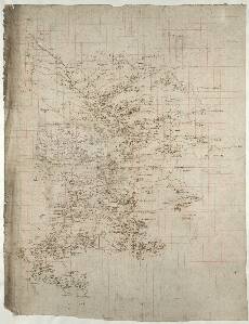
| Name: | Pont, Timothy, 1560?-1614? |
| Title: | [Nithsdale; part of Teviotdale] - Pont 35 |
| Imprint: | [ca. 1583-96] |
| Pagination: | 1 manuscript map ; 52 x 40 cm. |
| Shelfmark: | Adv.MS.70.2.9 (Pont 35) |
| Notes: | This manuscript, known as Pont 35 contains two separate maps, usually referred to as Pont 35(1) and Pont 35(2). Pont 35(1), the larger of the maps, covers the whole of the drainage basin of the River Nith. This is the area from the Solway Firth in the south to the headwaters of the Nith near Cumnock in the north west. In the north east is the head of the Water of Dunedyn (Duneaton Water), in the parish of Crafordjhon (Crawfordjohn). The smaller of the maps, Pont 35(2) is drawn at 180o to the larger map, and shows the valley of the River Teviot from Hawick in the west to Ancrum in the east, as well as the valley of the Ale Water from its confluence with the River Teviot, near Ancrum, to Ashkirk in the west. In the north east corner a short length of the River Tweed is shown. South of the River Teviot, the drainage basin of the Rule Water is mapped.
View the Pont Maps website. View maps by Blaeu and Robert and James Gordon. |
| Zoom Into Map: | Click on the map to view in greater detail. |