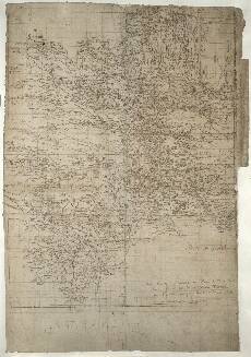
| Notes: | This large and very detailed map encompasses most of the drainage basin of the River Clyde, plus the headwaters of the rivers Annan and Tweed. The northern boundary is formed by the River Kelvin, with Kirkintilloch depicted. The slightly ragged eastern boundary runs broadly south southeast, skirting to the east of Caldercruix and on to Dunsyre Hill and finally Dolphinton. The southern boundary encloses the headwaters of the River Clyde at Queensberry hill, between Moffat and Thornhill. The western boundary runs north west along the watershed, just enclosing Sanquhar, and ending at the headwaters of the River Calder.- This is the only Pont map to bear a date (top corner near Kirkintilloch):
Sept. et
Octobr.
1596 Descri
pta 1596 is one of the very few fixed dates we possess for Pont's maps. - In terms of the sheer number of place names on this sheet, this is the most informative Pont map.
- Two mines are located by name. One of these is a lead mine on the Glengonnyr W:[ater] south west of Abingdon.
- There is a prominent inscription in Dutch in a secretary hand in one corner of the sheet. Despite the fact that the person who wrote this note has not been identified, it provides evidence that the map was once in Holland, presumably at the Amsterdam printing house of Joan Blaeu. The note reads:
De bergen uyt welcke de Anand Clyd en Tueedd
haren oirspronck hebben worden ghenaemt Tintock
hier zijn auri argentifodinen. Voorder't beste / maer
nict de moeyte waerd / nu loot en potloot which translates roughly as: The mountains where the Annan Clyde and Tweed
have their sources are called Tintock
There were once very good gold mines here, but they are now not worth the
trouble, only lead and graphite - The scale bar (bottom) may have been added later by Robert Gordon. It may have also been Gordon who drew the grid lines over the sheet, as the numerals in the bottom left appear to be in Gordon's hand writing.
- This map is overlapped in the north by Pont 32, and Pont 33; and in the south east there is minimal overlap with Pont 35.
- The following manuscript maps by Robert Gordon include at least part of this sheet: 6, 48, 49, 50, 55, 56, 57, 62, and 63.
- Pont 34 was the source of information for Joan Blaeu's printed maps Glottiana Praefectura Inferior and Glottiana Praefectura Superior, which in combination broadly cover the same area as this sheet. In addition, there is minimal overlap with five other Blaeu maps: Tvedia, Coila, Renfroana, Levinia, and Sterlinensis.
View the Pont Maps website. View maps by Blaeu and Robert and James Gordon. |