Maps of Scotland
| Field | Content |
|---|---|
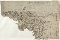
| Name: | Pont, Timothy, 1560?-1614? |
| Title: | [Renfrewshire] - Pont 33 |
| Imprint: | [ca. 1583-96] |
| Pagination: | 1 manuscript map ; 26 x 38 cm. |
| Shelfmark: | Adv.MS.70.2.9 (Pont 33) |
| Notes: | This map covers an area mainly south of the River Clyde, although it does take in Dumbarton to the north of the river. Ruglan (Rutherglen) and the drainage basin of the White Cart Water define the eastern boundary of the map. In the south east corner are the headwaters of several tributary burns to the White Cart Water, on the north face of Corse Hill (1230ft). The very irregular south western boundary runs along the watershed between the Ayrshire coast and the Clyde Valley, from Wemyss Bay in the west to Corse Hill in the east.
View the Pont Maps website. View maps by Blaeu and Robert and James Gordon. |
| Zoom Into Map: | Click on the map to view in greater detail. |