Maps of Scotland
| Field | Content |
|---|---|
| Name: | Pont, Timothy, 1560?-1614? |
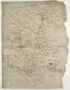
| Title: | [Strathardle; Glenshee and Glenericht] - Pont 27 |
| Imprint: | [ca. 1583-96] |
| Pagination: | 1 manuscript map ; 40 x 29 cm. |
| Shelfmark: | Adv.MS.70.2.9 (Pont 27) |
| Notes: | This map shows the drainage basins of the River Ardle flowing through Strathardle and of the Black Water flowing through Glen Shee. Along the southern margin is the River Isla south east of Rattray. The western margin of the map is marked by Loch Binchaly (Benachally) in the southwest and Ben Vrackie (a 2759 foot high hill) in the north west. The most northerly points are Bin-glo (Beinn a' Ghlo, 3673ft, top left) and Loch nan Eun (top). The eastern boundary is marked by the drainage of the Alyth Burn, Month-blair (Mount Blair, 2442ft), and the western side of the upper part of Glen Isla.
Baron Re... his cheef duelling place There is a further note on duelling at Loch Sesaturr (Loch Shechernich or Loch Beanie, upper right) in Glenshee which says: Loch Sesatur sumtyms [th]e At the top of the map a note says: a great mountayn, possibly a reference to the 3073ft high An Socach. At Stron (Strome, lower centre) Pont writes: w[i]th ancie[n]t rui[n]es of a fortress View the Pont Maps website. View maps by Blaeu and Robert and James Gordon. |
| Zoom Into Map: | Click on the map to view in greater detail. |