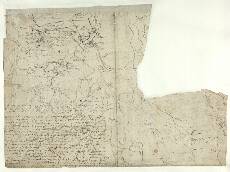
| Notes: | Pont 22(1)-(2) are on the front of the sheet. The other, Pont 22(3) is on the reverse side and is described here. At first sight this rather scruffy, altered map, partly over-written by text, may look incomprehensible, but with care we can make out its location. It shows an area known as Lochaber (top), far from the areas shown on the front of this sheet. The name Maim Moir (centre) relates to the Mamore Forest. The several lochs shown are Lochs Linnhe, Lochy, Ness, Eil, Arkaig, Garry, Leven, and Treig. Also on the back is a considerable amount of text. - This map was probably an early draft. It may have been used as a source for the very neatly drawn map on Pont 13.
- Despite its untidy appearance it is a useful source of information. It includes over 60 names, and provides at least 3 place-names not to be found on any other map by Pont, Robert Gordon, or Joan Blaeu: Avon Ygan, Corpach, and Torinferg (Stone, 1989)
- The lines of text which partly cover the map have been transcribed by Stone (1989). We reproduce this in full:
Item th[ere] cometh a wat[er] 4 m[ile]s long out of the north west syd of bin atyeo[ur] callit puttay /
in the end of loch lagan nixt badenoch it runeth throw glen puttay it hath but certaine /
in it. it falleth p[ar]tly out of burn euin. Item winchart mure scorne leag rhuybaid schu /
by is Khonyknapach hard by porldowbraik [th]ese ar in glen pattage[.] Ite[m] memstir w[ith] ald m /
running out of cory nawar [th]is burne passeth to avo[n] pattay[.] It[em] the kirk of laggan chy/
the north syd of pattich at the heid of loch laggan. Item bewest [th]e Tullich cromb /
the kirk 2 m[iles] of wood to abir ardo[ur] & ald ardo[ur] iiii m[iles] thence chalyeros w[ith] ald chaly /
coming out of cory chalyeros 2 m[iles] thence mvig crag chalyeach at [th]e cumming of Spe /
out of loch laggan. Ite[m] forne[n]t mvy for said is forr binallabyn or know of quhaip /
by [the] sam and...niden at [th]e west end of the loch cory chouspich is iii m[iles] frome [th]e f /
thence stron...ar a m[ile] thence ardinrug ite[m] iii m[iles] from the former is Muy-Etre-ta[.] /
Item petrack iii m[iles] thence knoyish [lu?]nan[.] Item kan loch at [th]e end fornent [th]e kirk a m[ile] the /
dowi upon [th]e south syd of [th]e wate[r] of pattaik[.] Item Dryvmenourd a good seat \ it is a tria /
mounth distingusching badenoch & lochabyr[.] Ite[m] from this runith the wat[er] of maissy fall[.] /
Item stramasch [th]e first seat on Maschi[.] Item tir segoun upon the ficht of the loch /
Dunbartane crag is [th]e rowinis of the ald castell callit sumtym Dountalair[.] Item be /
Item besyd tullochchromb strath hwmiachkan w[i]th Ald Chrumachard & Loch Chrunac[.] /
Item the Stryip that runs so est upon the head of the \wyld /
Month & hillis of Mynnygeg is cal Keuchennin louib[.] Ite[m] the Moss discending doon upon the other syd 3 m[iles] bewest Skairs /
called Lekkenin Teuuan in the head of the Kronnlaid being the first Scheeles in Bad. / - Robert Gordon also transcribed this text in his 'Topographical Notices of Scotland', reproduced in Mitchell (1907; ii, 599-600). This transcription is easier to interpret, and fuller, as it was made before the edge of Pont 22 was truncated.
- See also Pont 12 (front) and 13 for coverage of the southern half of this area. Pont 5 includes a small portion of the north east of this map.
- Relevant manuscript maps by Gordon are sheets: 2, 3, 4, 5, 6, 25, 36, 37, and 38. » The printed map of Braid-Allaban by Blaeu is relevant, as are small parts of his Aebudae Insulae, Mula Insula, and Lorna.
View the Pont Maps website. View maps by Blaeu and Robert and James Gordon. |