Estate Maps, 1750s-1900s

| Name: | Tait, James, ca. 1739 - ca. 1797 |
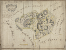
| Title: | Plan of the Back Gatas Lying in the Parish of Kirkcudbright - A Collection of Surveys of Scottish Estates of the Earl of Selkirk |
| Imprint: | 1764 |
| Pagination: | 1 map: col., 71.9 × 94.9 cm |
| Notes: | Inscribed in pen and brown ink, upper left: "No 16 Farms No 44 & 45"; in pen and brown ink, upper left: "A plan of the | BACK-GATAS | Lying in the Parish of | Kirkcudbright | WITH THE ENVIRONS"; in pen and brown ink, upper left: "N.B. The two Northwest Parks | are at present, Set as a part of the Banks, Farm | these Extents are, however, Stated by | themselves, Schemes No 43 & 44 | The other Lands (presented by | Sloane) are Stated Scheme No 45"; in pen and brown ink, throughout, plan labeled and plots numbered; in pen and brown ink, lower center, bar scale labeled. Watermark:(similar to Heawood 1713; 1716) Fleur-de-Lis. Signed and dated in lower left: "Survey'd by Ja.s Tait 1764 &c" From A Collection of Surveys of Scottish Estates of the Earl of Selkirk (ca. 1808-1815). Courtesy of the Yale Centre for British Art through the Dumfries Archival Mapping Project. |
| Zoom Into Map: | Click on the map to view in greater detail. |