Ordnance Survey - Early Digital Cartography, 1970-1972
These maps illustrate some of Ordnance Survey's initial work in automated / digital mapping in the early 1970s. Ordnance Survey acquired its first digitising table in April 1970 and also a digital encoder for fitting the output to a stereoplotting machine. Thereafter progress was rapid, and following trials, in the financial year 1973-74, 92 maps at 1:1,250 and 179 square kilometres of 1:2,500 scale mapping were produced by digital methods.
- 1970 - [Plans of part of Higher Bebington, illustrating] supply of map data in digital form. Sheet A. Selected detail digitised and plotted at 1:1250 scale, unedited.
- 1970 - [Plans of part of Higher Bebington, illustrating] supply of map data in digital form. Sheet A. Sheet B. Comparison of unedited automatic plot with current 1:1250 scale map.
- 1970 - Bideford area experiment / plot at 1:25,000 scale by A.E.G. Gealux light spot projector
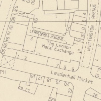
- 1971 - [O.S. plan of part of central London bounded by Houndsditch, Bishopsgate and Leadenhall Street.] Digitised by d-mac Cartographic Digitiser ... and scribed by Calcomp Model 745 Precision Flatbed Plotter ...).
- 1971 - [O.S. plan of part of central London bounded by Houndsditch, Bishopsgate and Leadenhall Street.] Digitised by d-mac Cartographic Digitiser... and plotted by EP 138 Automatic Light Spot Projector on a Ferrouti master plotter ...).
- 1972 - [O.S. plan of the British Museum and environs] / Digitised by Ferranti Freescan Digitiser ... and plotted by EP 138 Automatic Light Spot Projector on a Ferranti master plotter ...).