Mapmakers
Your search for Scott returned 34 records.
Ordered chronologically (undated items first).
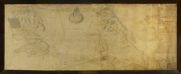
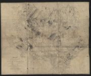
| Name: | Scott, John (fl. ca. 1756-72) | |
| Title: | A Survey of the Barony of Newtarbet, part of his Majesty’s Annexed Estates lying in the County of Ross, North Britain. John Scott delin | |
| Imprint: | Surveyed: 1756 | |
| Zoom Into Map: | Click on the map to view in greater detail. | |
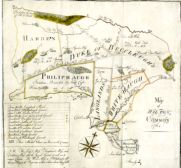
| Name: | Scott, Thomas Rutherford, Archibald, 1743-1779 | |
| Title: | Map of Wilton Common | |
| Imprint: | 1764 | |
| Zoom Into Map: | Click on the map to view in greater detail. | |
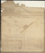
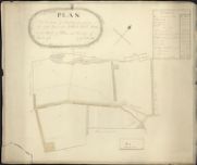
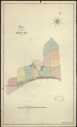
| Name: | Scott, Thomas | |
| Title: | A Draught of the Farm of Mounthooly: 1786. | |
| Imprint: | 1786 | |
| Zoom Into Map: | Click on the map to view in greater detail. | |
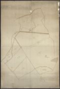
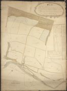
| Name: | Scott, George | |
| Title: | Plan of parts of the farm of Netherraw. | |
| Imprint: | 1796 | |
| Zoom Into Map: | Click on the map to view in greater detail. | |
| Name: | Scott, George | |
| Title: | A plan of Barnhills, the property of the Right Honourable the Lord Minto... | |
| Imprint: | 1809 | |
| Zoom Into Map: | Click on the map to view in greater detail. | |
| Name: | Scott, George | |
| Title: | Plan of the Lands of Moorfield the property of the Right Horourable Gilbert Earl Minto, in the Parish of Wilton and County of Roxburgh: 1813. | |
| Imprint: | 1813 | |
| Zoom Into Map: | Click on the map to view in greater detail. | |
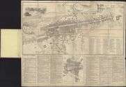
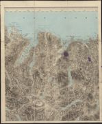
| Name: | Scott, Robert | |
| Title: | Map of the country adjacent to the City of Edinburgh : comprehending nearly the whole of the county and parts of adjacent counties. | |
| Imprint: | Edinburgh Fairbairn & Anderson, [ca. 1820] | |
| Zoom Into Map: | Click on the map to view in greater detail. | |
| Name: | Scott, Robert | |
| Title: | Plan of Edinburgh & Leith. Exhibiting all the present & intended improvements. And all the roads, &c. in the vicinity ... / engd. by R. Scott. | |
| Imprint: | Edinburgh : Thomsons Brothers, 1822. | |
| Zoom Into Map: | Click on the map to view in greater detail. | |
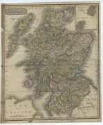
| Name: | Scott, Robert | |
| Title: | Scotland / (engd. ... by R. Scott.). | |
| Imprint: | Glasgow : Khull Blackie & Co &c, [1825?] | |
| Zoom Into Map: | Click on the map to view in greater detail. | |
| Name: | Scott, William | |
| Title: | Plan of the Farm of Rhives, 1829 | |
| Imprint: | 1829 | |
| Zoom Into Map: | Click on the map to view in greater detail. | |
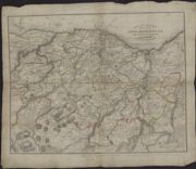
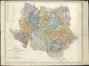
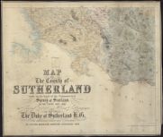
| Name: | Burnett, Gregory (fl. 1824-1844) Scott, William, fl. ca. 1830 | |
| Title: | Map of the county of Sutherland made on the basis of the trigonometrical survey of Scotland in the years 1831, 1832. 1833 – two-and-a-half miles to the inch. | |
| Imprint: | Dunrobin Castle, 1833 | |
| Zoom Into Map: | Click on the map to view in greater detail. | |
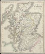
| Name: | Scott, Robert | |
| Title: | A map of Scotland distinguishing particularly the districts or countries inhabited by the Highland Clans / (engd. by R. Scott.). | |
| Imprint: | Glasgow : A Fullarton & Co, [1842] | |
| Zoom Into Map: | Click on the map to view in greater detail. | |
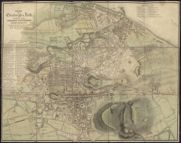
| Name: | Scott, Robert | |
| Title: | Plans of Edinburgh in the past and present, with its chronology / by Scott & Ferguson. | |
| Imprint: | [Edinburgh, 1843?] | |
| Zoom Into Map: | Click on the map to view in greater detail. | |
| Name: | Burnett, Gregory (fl. 1824-1844) Scott, William, fl. ca. 1830 | |
| Title: | Annotated copy of Burnett and Scott's map of Sutherland showing the proposed rearrangement of Sheep Farms as recommended by Andrew Hall in his report of 1847 | |
| Date: | 1847 | |
| Zoom Into Map: | Click on the map to view in greater detail. | |
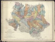
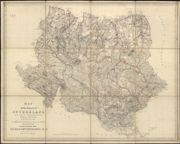
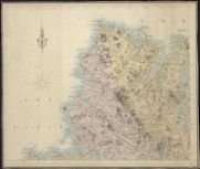
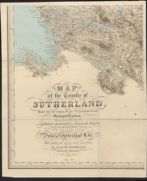
| Name: | Burnett, Gregory (fl. 1824-1844) Scott, William (fl. ca. 1830) Morrison, Hector (fl. 1830-1869) | |
| Title: | Map of the County of Sutherland based on the survey by Burnett and Scott, 1833. With additional names and corrections by Hector Morrison, Inverness, 1853 | |
| Imprint: | 1833, with additional names and corrections 1853 | |
| Zoom Into Map: | Click on the map to view in greater detail. | |
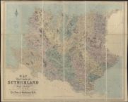
| Name: | Burnett, Gregory (fl. 1824-1844) Scott, William (fl. ca. 1830) Morrison, Hector (fl. 1830-1869) | |
| Title: | Map of the county of Sutherland made on the basis of the trigonometrical survey of Scotland in the years 1831, 1832. 1853 revision - half-inch to the mile. | |
| Imprint: | Edinburgh : W. & A. K. Johnson, [1855] | |
| Zoom Into Map: | Click on the map to view in greater detail. | |
| Name: | Burnett, Gregory (fl. 1824-1844) Scott, William (fl. ca. 1830) Morrison, Hector (fl. 1830-1869) | |
| Title: | Printed map of the County of Sutherland made on the basis of the Trigonometrical Survey of Scotland by Burnett and Scott (reduced version), 1833. With additional names and corrections by Hector Morrison, surveyor, Inverness. | |
| Imprint: | [post 1875] | |
| Zoom Into Map: | Click on the map to view in greater detail. | |
| Name: | Burnett, Gregory (fl. 1824-1844)) Scott, William (fl. ca. 1830) Morrison, Hector | |
| Title: | Map of the county of Sutherland made on the basis of the trigonometrical survey of Scotland in the years 1831, 1832 / by Gregory Burnett and William Scott ... with additional names and corrections by Hector Morrison ... 1855. | |
| Imprint: | Edinburgh : W & AK Johnston, [1855] | |
| Zoom Into Map: | Click on the map to view in greater detail. | |
| Name: | Burnett, Gregory (fl. 1824-1844) Scott, William, fl. ca. 1830 | |
| Title: | Map of the County of Sutherland made on the basis of the Trigonometrical Survey of Scotland by Burnett and Scott (reduced version), 1833. With annotations, 1847. | |
| Imprint: | 1833 | |
| Zoom Into Map: | Click on the map to view in greater detail. | |
| Name: | Burnett, Gregory (fl. 1824-1844)) Scott, William (fl. ca. 1830) Morrison, Hector | |
| Title: | Map of the County of Sutherland; Made on the basis of the Trigonometrical Survey of Scotland, 1831-2. Burnett and Scott. | |
| Imprint: | 1833 | |
| Zoom Into Map: | Click on the map to view in greater detail. | |
| Name: | Burnett, Gregory (fl. 1824-1844)) Scott, William (fl. ca. 1830) Morrison, Hector | |
| Title: | Map of the county of Sutherland, based on Burnett and Scott's survey, 1833 with additions by Hector Morrison, 1853. South-West Sutherland. | |
| Imprint: | 1833 with additions 1853 [1855] | |
| Zoom Into Map: | Click on the map to view in greater detail. | |
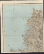
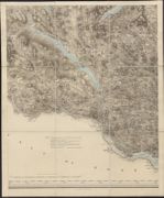
| Name: | Burnett, Gregory (fl. 1824-1844) Scott, William (fl. ca. 1830) Morrison, Hector | |
| Title: | Map of the county of Sutherland, based on Burnett and Scott's survey, 1833 with additions by Hector Morrison, 1853. North-West Sutherland. | |
| Imprint: | 1833 with additions 1853 [1855] | |
| Zoom Into Map: | Click on the map to view in greater detail. | |
| Name: | Burnett, Gregory (fl. 1824-1844) Scott, William (fl. ca. 1830) Morrison, Hector (fl. 1830-1869) | |
| Title: | Map of the County of Sutherland based on the survey by Burnett and Scott, 1833. With additional names and corrections by Hector Morrison, Inverness, 1853. Revised, 1865. | |
| Imprint: | Revised 1853, additional names and corrections 1868 | |
| Zoom Into Map: | Click on the map to view in greater detail. | |

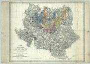
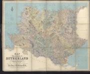
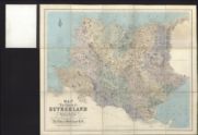
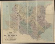
| Name: | Burnett, Gregory (fl. 1824-1844) Scott, William (fl. ca. 1830) Morrison, Hector (fl. 1830-1869) | |
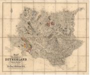
| Title: | Map of the county of Sutherland, made on the basis of the trigonometrical survey of Scotland in the years 1831 1832. 1868 revision - one-inch to the mile. | |
| Imprint: | Edinburgh : W. & A. K. Johnson, [1868] | |
| Name: | Burnett, Gregory (fl. 1824-1844) Scott, William (fl. ca. 1830) Morrison, Hector (fl. 1830-1869) | |
| Title: | Map of the County of Sutherland 1853 | |
| Imprint: | [post 1875] | |
| Zoom Into Map: | Click on the map to view in greater detail. | |
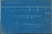
| Name: | James Scott & Son, Aberdeen | |
| Title: | Proposed Bridge over River Beauly at Beaufort Castle | |
| Imprint: | 1927 | |
| Zoom Into Map: | Click on the map to view in greater detail. | |

| Name: | James Scott & Son, Aberdeen | |
| Title: | Proposed Bridge over River Beauly at Beaufort Castle (alternative parapets) | |
| Imprint: | 1927 | |
| Zoom Into Map: | Click on the map to view in greater detail. | |
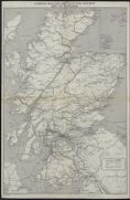
| Name: | London Midland and Scottish Railway Company. | |
| Title: | London Midland and Scottish Railway map of Scotland. | |
| Imprint: | [1930] | |
| Zoom Into Map: | Click on the map to view in greater detail. | |
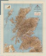
| Name: | Scottish Youth Hostels Association. | |
| Title: | Scottish Youth Hostels Association touring map of Scotland. | |
| Imprint: | Edinburgh, 1944 | |
| Zoom Into Map: | Click on the map to view in greater detail. | |
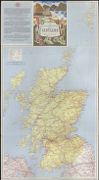
| Name: | Scottish Tourist Board. | |
| Title: | The Scottish Tourist Board's map of Scotland. | |
| Imprint: | Edinburgh : John Bartholomew & Son Ltd, [1963] | |
| Zoom Into Map: | Click on the map to view in greater detail. | |