Maps of Scotland
| Name: | Pont, Timothy, 1560?-1614? |
| Title: | [North Esk; South Esk] - Pont 30 |
| Imprint: | [ca. 1583-96] |
| Pagination: | 1 manuscript map ; 28 x 37 cm. |
| Shelfmark: | Adv.MS.70.2.9 (Pont 30) |
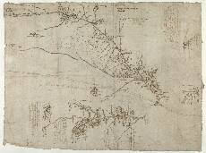
| Notes: | The manuscript known as Pont 30 contains 6 maps in total. Four maps, usually referred to as Pont 30(1) to Pont 30(4) are on the front of the sheet, shown here. The other two, Pont 30(5) to Pont 30(6) are on the back of the sheet. Pont 30(1) shows Glen Clova from the headwaters of the River South Esk in the north west (top right) to Finavon in Strathmore, 10km west south west of the town of Brechin, in the south east. In addition, the Prossynn R:[iver] (Prosen Water) is shown together with its western tributary the Caraty R[iver] (Carity Burn). Pont 30(2) and Pont 30(3) are two small maps related to Pont 30(1). They show in greater detail the area around Dykehead, about 5km north of Kirriemuir, at the confluence of the Prosen Water and the River South Esk. Pont 30(4) is separated from Pont 30(1) to Pont 30(3) by a double line, although the Carity Burn carries over from Pont 30(1). It includes Glen Mark and Glen Esk, from Loch Muick in the far north west, to a point just south of the confluence of the River North Esk and the West Water in the south east. Kairn of Month (Cairn o' Mount, a prominent hill) is shown in the east. In the far north is another substantial hill, Month Kyin (Mount Keen, 3080ft). (Mount Keen, 3080ft). Pont 30(1) River South Esk
ye draught of Mem: There are a number of other notes by Pont, mainly regarding locations, which were later re-written by Robert Gordon. For example: M[ar]cheth w[i]th Pont 30(2) and Pont 30(3) Dykehead For maps Pont 30(1), Pont 30(2) and Pont 30(3) View the Pont Maps website. View maps by Blaeu and Robert and James Gordon. |
| Zoom Into Map: | Click on the map to view in greater detail. |