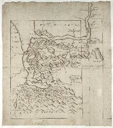
| Notes: | This map focuses on the area between Glen Coe and Glen Nevis in the western Highlands. It shows part of the Ardgour peninsula to the west west (top) and Rannoch Moor to the southeast (bottom). The north coast of Loch Lyon (Loch Leven) is well depicted. Scotland's highest mountain, the 4406ft (1343m) high Ben Nevis (Bin Neuesh), is clearly drawn in profile (top right). - This manuscript appears in a very carefully drawn state, perhaps also reflecting Robert Gordon’s substantial overwriting on top of Pont’s original ink.
- This manuscript is titled in Pont's hand:
A description of
MAIMOIR [Mamore] in Loch-
abir wt[ith] ye placis ad-
ionying
be
Mr Timothee Pont
- There is evidence of additional information having been added by Robert Gordon. This includes over-writing, extra place-names, trees, and hill shading.
- The thick black frame was drawn later, possibly by Pont himself, Gordon or Sibbald. A decision appears to have been taken to exclude the area of Ben Nevis, which protrudes to the top right.
- Just to the south of the eastern end of Loch Lyon (Loch Leven) there is the only descriptive note on this map. It reads:
Many Fyrre Woods heir alongs - At Inner-Lochy (top right) is Inverlochy Castle. The crenulated enclosure shown by Pont was built in the late 13th century by the Comyn lords of Badenoch. At the time of Pont's visit it was in the possession of the powerful anti-Gael, the Earl of Huntly.
- There is some overlap between this sheet and the maps on Pont 12 and 22.
- The following maps by Gordon are relevant, at least in part: 2, 3, 4, 5, 6, 25, 36, 37, and 38.
- The map of Braid-Allaban by Joan Blaeu covers this area, as do minor parts of his Aebudae Insulae, Mula Insula and Lorna.
View the Pont Maps website. View the Pont Maps website. View maps by Blaeu and Robert and James Gordon. |