Maps of Scotland
| Field | Content |
|---|---|
| Name: | Pont, Timothy, 1560?-1614? |
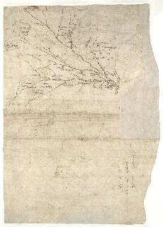
| Title: | [River Nethy] - Pont 6 (back) |
| Imprint: | [ca. 1583-96] |
| Pagination: | 1 manuscript map ; 41 x 28 cm. |
| Shelfmark: | Adv.MS.70.2.9 (Pont 6v) |
| Notes: | This is the back of the manuscript known as Pont 6. It contains two small maps referred to as Pont 6(2) and Pont 6(3). The front of the manuscript contains a third map, Pont 6(1). Of the two maps shown here, Pont 6(2) is a small, rather sparse map, showing the River Nethy and its tributaries from the point it enters the River Spey. It includes the settlement of Abyrnetthy (Abernethy). Pont 6(3) is a very small map of the River Dulnain (a tributary of the River Spey) at Duthill, north east of Carrbridge.
all wood Pont 6(3) River Dulnain
View the Pont Maps website. View maps by Blaeu and Robert and James Gordon. |
| Zoom Into Map: | Click on the map to view in greater detail. |