Maps of Scotland
| Field | Content |
|---|---|
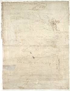
| Name: | Pont, Timothy, 1560?-1614? |
| Title: | [Farr] - Pont 2 (back) |
| Imprint: | [ca. 1583-96] |
| Pagination: | 1 manuscript map ; 31 x 42 cm. |
| Shelfmark: | Adv.MS.70.2.9 (Pont 2v) |
| Notes: | This is the back of the manuscript known as Pont 2. It contains two tiny maps, usually known as Pont 2(2) and Pont 2(3), of areas in the far north of Scotland. Another map, Pont 2(1), appears on the front of the sheet. Pont 2(2) covers the eastern shore of the Kyle of Tongue and Tongue Bay. Pont 2(3) covers Loch Meadie and Farr.
View the Pont Maps website. View maps by Blaeu and Robert and James Gordon. |
| Zoom Into Map: | Click on the map to view in greater detail. |