County maps, 1580s-1950s
Nearly all the detailed maps of parts of Scotland up to 1750 are derived from the work of three main mapmakers: Timothy Pont in the late 16th century, Robert Gordon in the mid-17th century, and John Adair in the late 17th century. The original survey work of Pont (and secondarily Gordon) was behind the magnificent county maps in the first atlas of Scotland by Joan Blaeu in 1654, and these maps, with some updated information from Adair and other sources, formed the basis of Herman Moll's atlases of 1725 and 1745.
More information on Timothy Pont can be found on our Pont maps website, including the history of his maps and textual notes and details of how they came to be used by Robert and James Gordon in the 1630s and 1640s. Robert Gordon of Straloch and his son James played a small but significant role in trying to fill gaps in Pont's map coverage for Joan Blaeu, as well as perhaps compiling maps for other purposes. Collectively, 61 manuscript maps by them survive, including both rough drafts and more detailed, finished maps, with considerable information gleaned from Pont's original survey work. However, for Fife, surveyed by James Gordon in 1641, and for the north-east (Aberdeenshire, Banffshire, and Moray), their maps include new information, updated to the mid-17th century, whilst for many parts of the Highlands their maps include some unique names, perhaps dateable to the late 16th century, not found on Pont and Blaeu maps.
Volume V of Blaeu's grand world atlas Theatrum orbis terrarum included 47 regional maps of Scotland, and for those areas of Scotland not covered by surviving Pont manuscripts these are the earliest detailed maps. In that 34 of the plates were engraved by Blaeu direct from Pont mapping, and a further seven from Robert Gordon's copies of Pont maps, the maps should be seen as representing the late 16th century rather than the mid-17th century. The work of the Gordons is only more obviously visible in their maps of Fife, Aberdeen and Banff, and Moray, and in two smaller-scale maps, Extima Scotiae and Braid-Allaban.
From the 1680s, John Adair was active in surveying and drafting new maps of Scottish counties. He was perhaps the first Scottish map-maker actively to use triangulation in his work. Twelve manuscript maps survive from his work at this time. They cover particularly the Lothians, Stirling, Fife, Kinross and southern Perthshire. Unfortunately, financial and other difficulties hampered much of John Adair's mapmaking, and not only were very few of his maps engraved during his life-time, but most of his manuscript maps were destroyed by fire in 1811. However, a few of his county maps were engraved and printed by Richard Cooper in the 1730s.
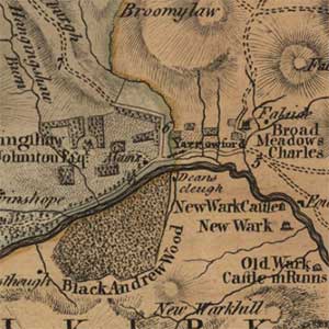
Herman Moll was an active and successful London-based map-engraver who brought out his Atlas of Scotland in 1725. It contained 34 maps of Scottish counties. Most are based on the Blaeu maps of the 1650s, but he did add additional information (especially roads). The second edition of his atlas (1745) contains the largest amount of additional information, and it is maps from this edition that are reproduced in this website. Finally, during the 1745 Jacobite uprising, several surveyors attached to or working for the Duke of Cumberland's army, such as William Edgar, Alexander Rutherford, and Thomas Willdey, created maps of central Scottish counties, particularly concentrating on roads, forts and sites of battles.
Maps of counties and regions of Scotland, 1750-1950s
The age of the county map really began in Scotland in the 1760s, when a number of land surveyors created new, detailed maps of all the counties of Scotland, with maps from updated surveys often issued every 20 or 30 years. A number of factors motivated this new mapping, particularly agricultural development, the enclosure of common land, political stability and relative economic prosperity. Land surveying increasingly emerged as a distinct profession, with surveyors often working for the Commissioners for the Forfeited or Annexed Estates or for larger landowners. These surveyors often combined mathematical knowledge with practical skills in land management. Also, from 1759, the Society of Arts in London gave grants for maps of counties at a scale of at least one-inch to the mile based on accurate trigonometric surveys. For most of Scotland, these county maps are the most detailed revised portrayal of the landscape since the Pont surveys 200 years earlier.
The more densely populated Lowlands and eastern districts of Scotland tended to be mapped first, with more frequent new editions. The surveys of the Lothians by John Laurie in the 1760s were followed by the Armstrongs' maps of the 1770s covering Berwickshire, Ayrshire, and Peebles-shire, whilst Selkirkshire, Fife and Kinross, Angus and Kirkcudbrightshire were mapped by the renowned and prolific Scottish surveyor John Ainslie in the 1780s. The rest of Scotland was soon covered by other surveyors, including James Stobie, George Langlands, William Crawford, John Blackadder, William Forrest, and James Knox. As well as showing natural features such as relief, rivers, woodland, lochs and coastlines, a range of human settlements are shown and named for the first time, including many isolated farms and hamlets, whilst parish and county boundaries are often highlighted in colour.
From 1818 to 1830 the Edinburgh-based map publisher John Thomson began work on his monumental Atlas of Scotland, which, when completed in 1832, included 58 detailed county maps. Although some of his maps were engraved from existing maps and sometimes only partially updated, he commissioned new surveys of several counties, and these were undertaken by William Johnson in the 1820s. Many people were employed in the project, including respected local people to attest to the accuracy of the map, and engravers in Edinburgh and London. Although the Atlas project was ultimately to bankrupt Thomson by 1830, the county maps - often at large scales of one and two miles to the inch - and the atlases containing them survive, providing the most detailed picture of Scotland prior to the Ordnance Survey. The Atlas includes a list of sources consulted, attractive colour plates showing heights of mountains, a panorama and lengths of rivers, and a gazetteer of the larger places on all the maps.