Your subject search for Building returned 80 records.
Ordered chronologically (undated items first).
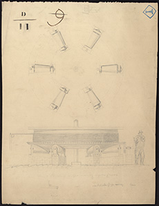
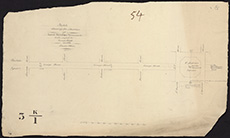
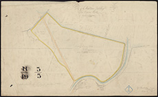
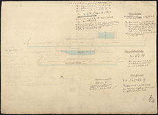
| Description: | Burntisland. Western Bay & Quarry | |
| Place: | Burntisland | |
| County: | Fife | |
| Subject: | Building/Monument | |
| Inventory: | Drawing | |
| Colour: | Colour | |
| Media: | Graphite; Hand coloured; Ink | |
| Object: | Folded | |
| Physical: | Paper | |
| Size: | 635 mm x 1165 mm | |
| Shelfmark: | MS.5845, 95 | |
| Show location on map ? | ||
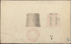
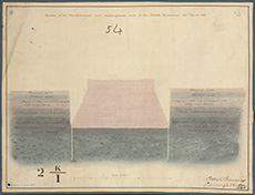
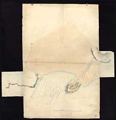
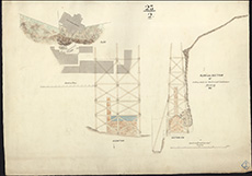
| Description: | Dunrobin. Design for Martello Towers | |
| Place: | Dunrobin | |
| County: | Sutherland | |
| Subject: | Building/Monument | |
| Inventory: | Series of two drawings | |
| Colour: | Colour | |
| Media: | Graphite; Hand coloured; Ink | |
| Object: | Flat | |
| Physical: | Paper | |
| Size: | 357 mm x 581 mm | |
| Shelfmark: | MS.5847, 101 | |
| Show location on map ? | ||
| Description: | Dunrobin. Design for Martello Towers | |
| Place: | Dunrobin | |
| County: | Sutherland | |
| Subject: | Building/Monument | |
| Inventory: | Series ot two drawings | |
| Colour: | Colour | |
| Media: | Graphite; Hand coloured; Ink | |
| Object: | Flat | |
| Physical: | Paper | |
| Size: | 354 mm x 581 mm | |
| Shelfmark: | MS.5847, 102 | |
| Show location on map ? | ||
 | ||
| Zoom Into Map: | Click on the map to view in greater detail. | |
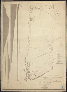
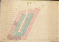
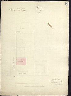
| Description: | Edinburgh, Leith. Ground on East side to be laid out for building | |
| Place: | Leith | |
| County: | Edinburgh | |
| Subject: | Building/Monument | |
| Inventory: | Engraving | |
| Colour: | B&W | |
| Media: | Ink; Printed | |
| Object: | Flat | |
| Physical: | Paper | |
| Size: | 752 mm x 547 mm | |
| Shelfmark: | MS.5848, 95 | |
| Show location on map ? | ||
 | ||
| Zoom Into Map: | Click on the map to view in greater detail. | |
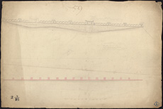
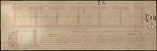
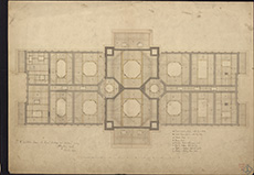
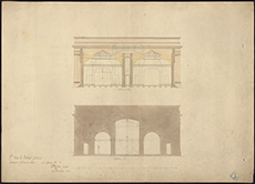
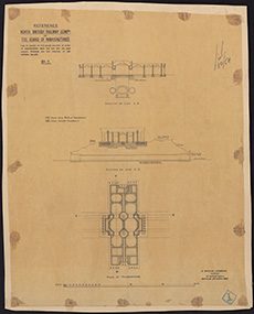
| Description: | Hopetoun House. Sections of approach to House | |
| Place: | Hopetoun House | |
| County: | West Lothian | |
| Subject: | Building/Monument | |
| Inventory: | Drawing | |
| Colour: | Colour | |
| Media: | Graphite; Hand coloured; Ink | |
| Object: | Folded | |
| Physical: | Paper | |
| Size: | 200 mm x 2030 mm | |
| Shelfmark: | MS.5852, 10 | |
| Show location on map ? | ||
 | ||
| Zoom Into Map: | Click on the map to view in greater detail. | |
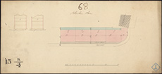
| Description: | Hopetoun House. Plan of park | |
| Place: | Hopetoun House | |
| County: | West Lothian | |
| Subject: | Building/Monument | |
| Inventory: | Drawing | |
| Colour: | Colour | |
| Media: | Hand coloured; Ink | |
| Object: | Folded | |
| Physical: | Paper/Linen/Cloth | |
| Size: | 915 mm x 1780 mm | |
| Shelfmark: | MS.5852, 11 | |
| Show location on map ? | ||
 | ||
| Zoom Into Map: | Click on the map to view in greater detail. | |
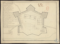
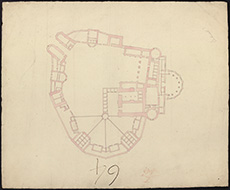
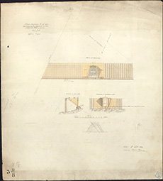
| Description: | Lerwick. Fort Charlotte | |
| Place: | Lerwick | |
| County: | Zetland | |
| Subject: | Building/Monument | |
| Inventory: | Drawing | |
| Colour: | B&W | |
| Media: | Ink | |
| Object: | Flat | |
| Physical: | Paper | |
| Size: | 275 mm x 380 mm | |
| Shelfmark: | MS.5855, 14 | |
| Show location on map ? | ||
 | ||
| Zoom Into Map: | Click on the map to view in greater detail. | |
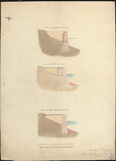
| Description: | Lord Melville's Monument. Section of base of the Melville Monument, endorsed no.27 (deleted) | |
| Place: | Edinburgh, Melville's Monument | |
| County: | Edinburgh | |
| Subject: | Building/Monument | |
| Colour: | B&W | |
| Media: | None | |
| Object: | Flat | |
| Physical: | Paper | |
| Size: | 530 x 635 mm | |
| Shelfmark: | Acc.10706, 359 | |
| Show location on map ? | ||
 | ||
| Zoom Into Map: | Click on the map to view in greater detail. | |
| Description: | Lord Melville's Monument. Section of base of the Melville Monument, endorsed no.28 (deleted) | |
| Place: | Edinburgh, Melville's Monument | |
| County: | Edinburgh | |
| Subject: | Building/Monument | |
| Colour: | B&W | |
| Media: | None | |
| Object: | Flat | |
| Physical: | Paper | |
| Size: | 530 x 635 mm | |
| Shelfmark: | Acc.10706, 360 | |
| Show location on map ? | ||
 | ||
| Zoom Into Map: | Click on the map to view in greater detail. | |
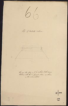
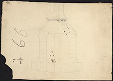
| Description: | Lord Melville's Monument. Drawing of the top of the Melville column. | |
| Place: | Edinburgh, Melville's Monument | |
| County: | Edinburgh | |
| Subject: | Building/Monument | |
| Colour: | B&W | |
| Media: | None | |
| Object: | Flat | |
| Physical: | Card | |
| Size: | 535 x 332 mm | |
| Shelfmark: | Acc.10706, 361 | |
| Show location on map ? | ||
 | ||
| Zoom Into Map: | Click on the map to view in greater detail. | |
| Description: | Lord Melville's Monument. Elevation of base of Melville's Monument, endorsed no.29 (deleted) | |
| Place: | Edinburgh, Melville's Monument | |
| County: | Edinburgh | |
| Subject: | Building/Monument | |
| Colour: | B&W | |
| Media: | None | |
| Object: | Flat | |
| Physical: | Paper | |
| Size: | 375 x 535 mm | |
| Shelfmark: | Acc.10706, 362 | |
| Show location on map ? | ||
 | ||
| Zoom Into Map: | Click on the map to view in greater detail. | |
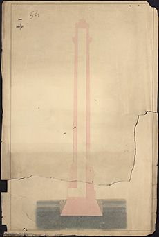
| Description: | Lord Melville's Monument. Section of column and foundations of Melville's Monument. (torn in two unequal parts) | |
| Place: | Edinburgh, Melville's Monument | |
| County: | Edinburgh | |
| Subject: | Building/Monument | |
| Colour: | Colour | |
| Media: | None | |
| Object: | Flat | |
| Physical: | Paper | |
| Size: | 1000 x 660 mm | |
| Shelfmark: | Acc.10706, 363 | |
| Show location on map ? | ||
 | ||
| Zoom Into Map: | Click on the map to view in greater detail. | |
| Description: | Lord Melville's Monument. Sections and plans for the base of the Melville Monument endorsed no.30 (deleted) | |
| Place: | Edinburgh, Melville's Monument | |
| County: | Edinburgh | |
| Subject: | Building/Monument | |
| Colour: | B&W | |
| Media: | None | |
| Object: | Flat | |
| Physical: | Paper | |
| Size: | 635 x 530 mm | |
| Shelfmark: | Acc.10706, 364 | |
| Show location on map ? | ||
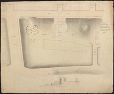
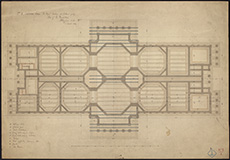
| Description: | Plan of Castle | |
| Place: | Lancaster | |
| County: | Lancashire | |
| Subject: | Building/Monument | |
| Colour: | Colour | |
| Media: | None | |
| Object: | Flat | |
| Physical: | Paper | |
| Size: | 520 x 640 mm | |
| Shelfmark: | Acc.10706, 396 | |
| Show location on map ? | ||
 | ||
| Zoom Into Map: | Click on the map to view in greater detail. | |
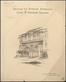
| Description: | St Andrew Square. Sketch of Station Approach from St Andrew Square' [Proposed design of Caledonian Station Entrance - from Ruthland Street] Architects: Frank W. Simon and Henry F. Kerr | |
| Place: | Edinburgh, St Andrew Square | |
| County: | Edinburgh | |
| Subject: | Building/Monument | |
| Shelfmark: | MS.5896, 6 | |
 | ||
| Zoom Into Map: | Click on the map to view in greater detail. | |
| Description: | Plan & elevation of a gin moving upon french, n.d | |
| Subject: | Building/Monument | |
| Shelfmark: | MS.5896, 9 | |
 | ||
| Zoom Into Map: | Click on the map to view in greater detail. | |
| Name: | Urquhart, William | |
| Description: | Doveran, River. Plan of Cruives and of Lord Fife's Flour Mill and of Cruive Dike | |
| Year: | 1782 | |
| County: | Banff | |
| Subject: | Building/Monument | |
| Inventory: | Tracing. 2 copies. | |
| Colour: | B&W | |
| Media: | Ink | |
| Object: | Flat | |
| Physical: | Transparent paper/Paper | |
| Size: | 335 mm x 547 mm | |
| Shelfmark: | MS.5847, 30 | |
| Show location on map ? | ||
| Name: | Urquhart, William | |
| Description: | Doveran, River. Plan of Cruives and of Lord Fife's Flour Mill and of Cruive Dike | |
| Year: | 1782 | |
| County: | Banff | |
| Subject: | Building/Monument | |
| Inventory: | Tracing. 2 copies. | |
| Colour: | B&W | |
| Media: | Ink | |
| Object: | Flat | |
| Physical: | Transparent paper/Linen/Cloth | |
| Size: | 225 mm x 351 mm | |
| Shelfmark: | MS.5847, 31 | |
| Show location on map ? | ||
| Description: | . Plan of Bridewell Prison, endorsed Edinburgh the Fourteinth June 1792. | |
| Year: | 1792 | |
| Place: | Edinburgh | |
| County: | Edinburgh | |
| Subject: | Building/Monument | |
| Colour: | Colour | |
| Media: | None | |
| Object: | Flat | |
| Physical: | Paper | |
| Size: | 770 x 625 mm | |
| Shelfmark: | Acc.10706, 397 | |
| Show location on map ? | ||
| Description: | Calton Jail. Calton Jail c. 1800 | |
| Year: | 1800 | |
| Place: | Edinburgh, Calton Jail | |
| County: | Edinburgh | |
| Subject: | Building/Monument | |
| Shelfmark: | MS.5896, 11 | |
 | ||
| Zoom Into Map: | Click on the map to view in greater detail. | |
| Name: | Stevenson, Robert, 1772-1850 | |
| Description: | Arbroath Abbey. Sketch and Drawings to accompany report – Robert Stevenson (1804) (2 drawings) | |
| Year: | 1804 | |
| Place: | Arbroath | |
| County: | Forfar | |
| Subject: | Building/Monument | |
| Colour: | Colour | |
| Media: | None | |
| Object: | Folded | |
| Physical: | Paper | |
| Size: | 605 x 1200 mm | |
| Shelfmark: | Acc.10706, 672 | |
| Name: | Stevenson, Robert, 1772-1850 | |
| Description: | Arbroath Abbey. Sketch and Drawings to accompany report – Robert Stevenson (1804) (2 drawings) | |
| Year: | 1804 | |
| Place: | Arbroath | |
| County: | Forfar | |
| Subject: | Building/Monument | |
| Colour: | Colour | |
| Media: | None | |
| Object: | Folded | |
| Physical: | Paper | |
| Size: | 460 x 1750 mm | |
| Shelfmark: | Acc.10706, 673 | |
| Name: | Playfair, William Henry, 1790-1857 | |
| Description: | Edinburgh: Elm Row. Plan of block of buildings between Elm Row, Leopold Place, Windsor Street and Montgomery Street | |
| Year: | 1811 | |
| Place: | Edinburgh, Elm Row | |
| County: | Edinburgh | |
| Subject: | Building/Monument | |
| Inventory: | Drawing | |
| Colour: | Colour | |
| Media: | Graphite; Hand coloured; Ink | |
| Object: | Flat | |
| Physical: | Paper | |
| Size: | 655 mm x 460 mm | |
| Shelfmark: | MS.5848, 44 | |
| Show location on map ? | ||
 | ||
| Zoom Into Map: | Click on the map to view in greater detail. | |
| Description: | . Sketch of a plan and section of ground for a new Justiciary Courthouse and prison, on paper watermarked 1812(?) | |
| Year: | 1812 | |
| Place: | Edinburgh | |
| County: | Edinburgh | |
| Subject: | Building/Monument | |
| Colour: | Colour | |
| Media: | None | |
| Object: | Flat | |
| Physical: | Paper | |
| Size: | 525 x 640 mm | |
| Shelfmark: | Acc.10706, 394 | |
| Show location on map ? | ||
 | ||
| Zoom Into Map: | Click on the map to view in greater detail. | |
| Description: | . Plan of Bridewell Prison (Calton) on paper watermarked 1812(?) | |
| Year: | 1812 | |
| Place: | Edinburgh | |
| County: | Edinburgh | |
| Subject: | Building/Monument | |
| Colour: | Colour | |
| Media: | None | |
| Object: | Flat | |
| Physical: | Paper | |
| Size: | 520 x 640 mm | |
| Shelfmark: | Acc.10706, 395 | |
| Show location on map ? | ||
 | ||
| Zoom Into Map: | Click on the map to view in greater detail. | |
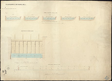
| Description: | Belton Waulk Mill. Plan and Section of Belton Waulk Mill shewing the Mill Lead and Back Fall in their present state, 1814 | |
| Year: | 1814 | |
| Place: | Beltonford | |
| County: | East Lothian | |
| Subject: | Building/Monument | |
| Colour: | Colour | |
| Media: | None | |
| Object: | Flat | |
| Physical: | Paper | |
| Size: | 330 x 420 mm | |
| Shelfmark: | Acc.10706, 679 | |
 | ||
| Zoom Into Map: | Click on the map to view in greater detail. | |
| Description: | Belton Waulk Mill. Plan and Section of Belton Waulk Mill shewing the Mill Lead and Back Fall As proposed to be altered, 1814 | |
| Year: | 1814 | |
| Place: | Beltonford | |
| County: | East Lothian | |
| Subject: | Building/Monument | |
| Colour: | Colour | |
| Media: | None | |
| Object: | Folded | |
| Physical: | Paper | |
| Size: | 610 x 395 mm | |
| Shelfmark: | Acc.10706, 680 | |
| Name: | Stevenson, Robert, 1772-1850 | |
| Description: | Westbarns. Survey of Mills | |
| Year: | 1814 | |
| Place: | Westbarns | |
| County: | East Lothian | |
| Subject: | Building/Monument | |
| Inventory: | Drawing | |
| Colour: | Colour | |
| Media: | None | |
| Object: | Folded | |
| Physical: | Card | |
| Size: | 610 x 1030 mm | |
| Shelfmark: | MS.5864, 1 | |
| Show location on map ? | ||
 | ||
| Zoom Into Map: | Click on the map to view in greater detail. | |
| Name: | Stevenson, Robert, 1772-1850 | |
| Description: | Westbarns. Survey and sections of mills | |
| Year: | 1815 | |
| Place: | Westbarns | |
| County: | East Lothian | |
| Subject: | Building/Monument | |
| Inventory: | Drawing | |
| Colour: | Colour | |
| Media: | Linen/Cloth | |
| Object: | Folded | |
| Physical: | Card | |
| Size: | 740 x 1290 mm | |
| Shelfmark: | MS.5864, 2 | |
| Show location on map ? | ||
 | ||
| Zoom Into Map: | Click on the map to view in greater detail. | |
| Description: | Deyhouse. Sketch of farm | |
| Year: | 1816 | |
| Place: | Deyhouse | |
| County: | Forfar | |
| Subject: | Building/Monument | |
| Inventory: | Drawing | |
| Colour: | B&W | |
| Media: | Hand coloured; Ink | |
| Object: | Folded | |
| Physical: | Paper | |
| Size: | 710 mm x 1146 mm | |
| Shelfmark: | MS.5847, 10 | |
| Show location on map ? | ||
| Description: | Edinburgh: Easter RoadMidlothian. Sketch plan and section showing proposed improvements at the Quarry Holes | |
| Year: | 1817 | |
| Place: | Edinburgh, Easter Road | |
| County: | Edinburgh | |
| Subject: | Building/Monument | |
| Inventory: | Drawing | |
| Colour: | Colour | |
| Media: | Graphite; Hand coloured; Ink | |
| Object: | Flat | |
| Physical: | Paper | |
| Size: | 540 mm x 820 mm | |
| Shelfmark: | MS.5848, 40 | |
| Show location on map ? | ||
 | ||
| Zoom Into Map: | Click on the map to view in greater detail. | |
| Description: | Edinburgh, Powderhall. Section relative to Bonnington Mills | |
| Year: | 1819 | |
| Place: | Edinburgh, Powderhall | |
| County: | Edinburgh | |
| Subject: | Building/Monument | |
| Inventory: | Series of 2 drawings | |
| Colour: | Colour | |
| Media: | Graphite; Hand coloured; Ink | |
| Object: | Folded | |
| Physical: | Paper | |
| Size: | 325 mm x 1052 mm | |
| Shelfmark: | MS.5849, 52-53 | |
| Show location on map ? | ||
| Description: | Lord Melville's Monument. Sketch showing the situation of Lord Melville's Monument with respect to George Street and the Excise Office, 1821. | |
| Year: | 1821 | |
| Place: | Edinburgh, Melville's Monument | |
| County: | Edinburgh | |
| Subject: | Building/Monument | |
| Colour: | B&W | |
| Media: | None | |
| Object: | Flat | |
| Physical: | Paper | |
| Size: | 315 x 530 mm | |
| Shelfmark: | Acc.10706, 357 | |
| Show location on map ? | ||
 | ||
| Zoom Into Map: | Click on the map to view in greater detail. | |
| Name: | Stevenson, Robert, 1772-1850 | |
| Description: | Lord Melville's Monument. Section of the foundation-pit and underground work of the Melville Monument, Robert Stevenson, 1821. | |
| Year: | 1821 | |
| Place: | Edinburgh, Melville's Monument | |
| County: | Edinburgh | |
| Subject: | Building/Monument | |
| Colour: | Colour | |
| Media: | Linen/Cloth | |
| Object: | Flat | |
| Physical: | Paper | |
| Size: | 350 x 465 mm | |
| Shelfmark: | Acc.10706, 358 | |
| Show location on map ? | ||
 | ||
| Zoom Into Map: | Click on the map to view in greater detail. | |
| Name: | Playfair, William Henry, 1790-1857 | |
| Description: | Edinburgh, Royal Terrace. Cellars and sections of houses | |
| Year: | 1821 | |
| Place: | Edinburgh, Royal Terrace | |
| County: | Edinburgh | |
| Subject: | Building/Monument | |
| Inventory: | Series of 6 drawings | |
| Colour: | Colour | |
| Media: | Hand coloured; Ink | |
| Object: | Flat | |
| Physical: | Paper | |
| Size: | 170 mm x 528 mm | |
| Shelfmark: | MS.5849, 74 | |
 | ||
| Zoom Into Map: | Click on the map to view in greater detail. | |
| Name: | Playfair, William Henry, 1790-1857 | |
| Description: | Edinburgh, Royal Terrace. Cellars and sections of houses | |
| Year: | 1821 | |
| Place: | Edinburgh, Royal Terrace | |
| County: | Edinburgh | |
| Subject: | Building/Monument | |
| Inventory: | Series of 6 drawings | |
| Colour: | Colour | |
| Media: | Hand coloured; Ink | |
| Object: | Flat | |
| Physical: | Paper | |
| Size: | 250 mm x 446 mm | |
| Shelfmark: | MS.5849, 75 | |
| Name: | Playfair, William Henry, 1790-1857 | |
| Description: | Edinburgh, Royal Terrace. Cellars and sections of houses | |
| Year: | 1821 | |
| Place: | Edinburgh, Royal Terrace | |
| County: | Edinburgh | |
| Subject: | Building/Monument | |
| Inventory: | Series of 6 drawings | |
| Colour: | Colour | |
| Media: | Hand coloured; Ink | |
| Object: | Flat | |
| Physical: | Paper | |
| Size: | 322 mm x 525 mm | |
| Shelfmark: | MS.5849, 76 | |
| Name: | Playfair, William Henry, 1790-1857 | |
| Description: | Edinburgh, Royal Terrace. Cellars and sections of houses | |
| Year: | 1821 | |
| Place: | Edinburgh, Royal Terrace | |
| County: | Edinburgh | |
| Subject: | Building/Monument | |
| Inventory: | Series of 6 drawings | |
| Colour: | Colour | |
| Media: | Hand coloured; Ink | |
| Object: | Flat | |
| Physical: | Paper | |
| Size: | 275 mm x 504 mm | |
| Shelfmark: | MS.5849, 77 | |
| Name: | Playfair, William Henry, 1790-1857 | |
| Description: | Edinburgh, Royal Terrace. Cellars and sections of houses | |
| Year: | 1821 | |
| Place: | Edinburgh, Royal Terrace | |
| County: | Edinburgh | |
| Subject: | Building/Monument | |
| Inventory: | Series of 6 drawings | |
| Colour: | Colour | |
| Media: | Hand coloured; Ink | |
| Object: | Flat | |
| Physical: | Paper | |
| Size: | 242 mm x 537 mm | |
| Shelfmark: | MS.5849, 78 | |
 | ||
| Zoom Into Map: | Click on the map to view in greater detail. | |
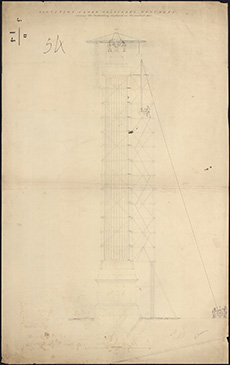
| Name: | Stevenson, Robert, 1772-1850 | |
| Description: | Lord Melville's Monument. Elevation of Lord Melville's Monument showing the scaffolding employed in it's erection. R Stevenson, 1822. | |
| Year: | 1822 | |
| Place: | Edinburgh, Melville's Monument | |
| County: | Edinburgh | |
| Subject: | Building/Monument | |
| Colour: | B&W | |
| Object: | Flat | |
| Physical: | Paper | |
| Size: | 990 x 615 mm | |
| Shelfmark: | Acc.10706, 356 | |
| Show location on map ? | ||
 | ||
| Zoom Into Map: | Click on the map to view in greater detail. | |
| Description: | St. Kilda. Sketch of church and missionary house | |
| Year: | 1826 | |
| Place: | St. Kilda | |
| County: | Inverness | |
| Subject: | Building/Monument | |
| Inventory: | Drawing | |
| Colour: | Colour | |
| Media: | ABF | |
| Object: | Flat | |
| Physical: | Paper | |
| Size: | 600 x 430 mm | |
| Shelfmark: | MS.5862, 9 | |
| Show location on map ? | ||
 | ||
| Zoom Into Map: | Click on the map to view in greater detail. | |
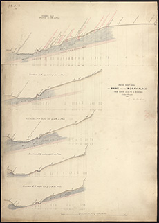
| Description: | . Sections of the Bank upon the northern side of Moray & Ainslie Place, 1827. | |
| Year: | 1827 | |
| Place: | Edinburgh | |
| County: | Edinburgh | |
| Subject: | Building/Monument | |
| Colour: | Colour | |
| Media: | None | |
| Object: | Flat | |
| Physical: | Paper | |
| Size: | 515 x 620 mm | |
| Shelfmark: | Acc.10706, 384 | |
| Show location on map ? | ||
 | ||
| Zoom Into Map: | Click on the map to view in greater detail. | |
| Description: | . Plan and section of the retaining arches for the grounds behind Mr Lorimer's house in Ainslie Place, 1829. | |
| Year: | 1829 | |
| Place: | Edinburgh | |
| County: | Edinburgh | |
| Subject: | Building/Monument | |
| Colour: | Colour | |
| Media: | None | |
| Object: | Flat | |
| Physical: | Paper | |
| Size: | 530 x 645 mm | |
| Shelfmark: | Acc.10706, 383 | |
| Show location on map ? | ||
 | ||
| Zoom Into Map: | Click on the map to view in greater detail. | |
| Name: | Stevenson, Robert, 1772-1850 | |
| Description: | Edinburgh: Canongate. Survey of Tan Work of Messrs. Wm. & Oliver Gilmore | |
| Year: | 1834 | |
| Place: | Edinburgh, Canongate | |
| County: | Edinburgh | |
| Subject: | Building/Monument | |
| Inventory: | Drawing | |
| Colour: | Colour | |
| Media: | Graphite; Hand coloured; Ink | |
| Object: | Flat | |
| Physical: | Paper | |
| Size: | 547 mm x 753 mm | |
| Shelfmark: | MS.5848, 16 | |
| Show location on map ? | ||
| Description: | . Plan and elevation of a doorway. Pladda, 1836. | |
| Year: | 1836 | |
| Place: | Pladda | |
| County: | Bute | |
| Subject: | Building/Monument | |
| Colour: | Colour | |
| Media: | None | |
| Object: | Flat | |
| Physical: | Paper | |
| Size: | 490 x 280 mm | |
| Shelfmark: | Acc.10706, 516 | |
| Show location on map ? | ||
| Name: | Buchanan, George, 1790?-1852 | |
| Description: | . Plan of the Bank behind Moray Place and Ainslie Place ... From a survey by George Buchanan, Civil Engineer, 1837. | |
| Year: | 1837 | |
| Place: | Edinburgh | |
| County: | Edinburgh | |
| Subject: | Building/Monument | |
| Colour: | Colour | |
| Media: | None | |
| Object: | Folded | |
| Physical: | Paper | |
| Size: | 820 x 1250 mm | |
| Shelfmark: | Acc.10706, 385 | |
| Show location on map ? | ||
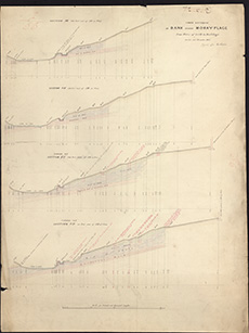
| Name: | Buchanan, George, 1790?-1852 | |
| Description: | . Cross sections of the bank behind Moray Place from Water of Leith to Building. 1837. George Buchanan. | |
| Year: | 1837 | |
| Place: | Edinburgh | |
| County: | Edinburgh | |
| Subject: | Building/Monument | |
| Colour: | Colour | |
| Media: | None | |
| Object: | Flat | |
| Physical: | Paper | |
| Size: | 920 x 650 mm | |
| Shelfmark: | Acc.10706, 387 | |
| Show location on map ? | ||
 | ||
| Zoom Into Map: | Click on the map to view in greater detail. | |
| Name: | Buchanan, George, 1790?-1852 | |
| Description: | . Cross sections of the bank behind Moray Place from Water of Leith to Building. 1837. George Buchanan. | |
| Year: | 1837 | |
| Place: | Edinburgh | |
| County: | Edinburgh | |
| Subject: | Building/Monument | |
| Colour: | Colour | |
| Media: | None | |
| Object: | Flat | |
| Physical: | Paper | |
| Size: | 880 x 655 mm | |
| Shelfmark: | Acc.10706, 388 | |
| Show location on map ? | ||
 | ||
| Zoom Into Map: | Click on the map to view in greater detail. | |
| Name: | Buchanan, George, 1790?-1852 | |
| Description: | . Cross sections of the bank behind Moray Place from Water of Leith to Building. 1837. George Buchanan. | |
| Year: | 1837 | |
| Place: | Edinburgh | |
| County: | Edinburgh | |
| Subject: | Building/Monument | |
| Colour: | Colour | |
| Media: | None | |
| Object: | Flat | |
| Physical: | Paper | |
| Size: | 990 x 665 mm | |
| Shelfmark: | Acc.10706, 389 | |
| Show location on map ? | ||
| Name: | Buchanan, George, 1790?-1852 | |
| Description: | . Cross sections of the bank behind Moray Place from Water of Leith to Building. 1837. George Buchanan. | |
| Year: | 1837 | |
| Place: | Edinburgh | |
| County: | Edinburgh | |
| Subject: | Building/Monument | |
| Colour: | Colour | |
| Media: | None | |
| Object: | Flat | |
| Physical: | Paper | |
| Size: | 995 x 665 mm | |
| Shelfmark: | Acc.10706, 390 | |
| Show location on map ? | ||
| Name: | Stevenson, Robert, 1772-1850 | |
| Description: | Edinburgh, Leith. Plan and section of part of building yard | |
| Year: | 1837 | |
| Place: | Leith | |
| County: | Edinburgh | |
| Subject: | Building/Monument | |
| Inventory: | Drawing | |
| Colour: | Colour | |
| Media: | Hand coloured; Ink | |
| Object: | Flat | |
| Physical: | Paper | |
| Size: | 545 mm x 660 mm | |
| Shelfmark: | MS.5848, 74 | |
| Show location on map ? | ||
| Name: | Stevenson, Robert, 1772-1850 | |
| Description: | Edinburgh, Leith. Sections of proposed walls | |
| Year: | 1837 | |
| Place: | Leith | |
| County: | Edinburgh | |
| Subject: | Building/Monument | |
| Inventory: | Drawing | |
| Colour: | Colour | |
| Media: | Hand coloured; Ink | |
| Object: | Flat | |
| Physical: | Paper | |
| Size: | 760 mm x 551 mm | |
| Shelfmark: | MS.5848, 75 | |
| Show location on map ? | ||
 | ||
| Zoom Into Map: | Click on the map to view in greater detail. | |
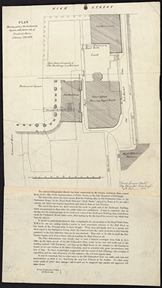
| Name: | Cousin, David | |
| Description: | . Plan showing part of the Parliament Square, with former site of President's Stairs, with written report. David Cousin, Architect, 1838. | |
| Year: | 1838 | |
| Place: | Edinburgh | |
| County: | Edinburgh | |
| Subject: | Building/Monument | |
| Colour: | B&W | |
| Media: | None | |
| Object: | Flat | |
| Physical: | Paper | |
| Size: | 445 x 245 mm | |
| Shelfmark: | Acc.10706, 393 | |
| Show location on map ? | ||
 | ||
| Zoom Into Map: | Click on the map to view in greater detail. | |
| Name: | Mason, John | |
| Description: | Westbarns. Plan of distillery and Park | |
| Year: | 1838 | |
| Place: | Westbarns | |
| County: | East Lothian | |
| Subject: | Building/Monument | |
| Inventory: | Drawing | |
| Colour: | Colour | |
| Media: | None | |
| Object: | Flat | |
| Physical: | Paper | |
| Size: | 330 x 540 mm | |
| Shelfmark: | MS.5864, 4 | |
| Show location on map ? | ||
 | ||
| Zoom Into Map: | Click on the map to view in greater detail. | |
| Name: | Duncan, John | |
| Description: | St. Monans. Sketch of premises in dispute | |
| Year: | 1841 | |
| Place: | St. Monans | |
| County: | Fife | |
| Subject: | Building/Monument | |
| Inventory: | ||
| Colour: | Colour | |
| Media: | None | |
| Object: | Flat | |
| Physical: | Card | |
| Size: | 575 x 920 mm | |
| Shelfmark: | MS.5862, 11 | |
| Show location on map ? | ||
| Description: | Penicuik. Bankmill Paper Mills, nd alterations | |
| Year: | 1846 | |
| Place: | Penicuik | |
| County: | Edinburgh | |
| Subject: | Building/Monument | |
| Inventory: | Drawing | |
| Colour: | B&W | |
| Media: | Graphite; Ink | |
| Object: | Flat | |
| Physical: | Paper | |
| Size: | 660 mm x 960 mm | |
| Shelfmark: | MS.5859, 5 | |
| Show location on map ? | ||
| Description: | Barlock. Quarry | |
| Year: | 1846 | |
| County: | Kirkcudbright | |
| Subject: | Building/Monument | |
| Inventory: | Drawing | |
| Colour: | Colour | |
| Media: | Graphite; Hand coloured; Ink | |
| Object: | Folded | |
| Physical: | Paper | |
| Size: | 1002 mm x 989 mm | |
| Shelfmark: | MS.5845, 20 | |
| Show location on map ? | ||
 | ||
| Zoom Into Map: | Click on the map to view in greater detail. | |
| Description: | Edinburgh, Leith. Plan of Granary | |
| Year: | 1847 | |
| Place: | Leith | |
| County: | Edinburgh | |
| Subject: | Building/Monument | |
| Inventory: | Series of 3 drawings | |
| Colour: | Colour | |
| Media: | Hand coloured; Ink | |
| Object: | Bound | |
| Physical: | Paper | |
| Size: | 525 mm x 372 mm | |
| Shelfmark: | MS.5848, 78 - 80 | |
| Show location on map ? | ||
| Name: | Playfair, William Henry, 1790-1857 | |
| Description: | Edinburgh, Mound. Exhibition Rooms-Royal Academy & Nat Gallery | |
| Year: | 1850 | |
| Place: | Edinburgh, Mound | |
| County: | Edinburgh | |
| Subject: | Building/Monument | |
| Inventory: | Drawing | |
| Colour: | Colour | |
| Media: | Hand coloured; Ink | |
| Object: | Flat | |
| Physical: | Paper | |
| Size: | 507 mm x 720 mm | |
| Shelfmark: | MS.5849, 10 | |
| Show location on map ? | ||
 | ||
| Zoom Into Map: | Click on the map to view in greater detail. | |
| Name: | Playfair, William Henry, 1790-1857 | |
| Description: | Edinburgh, Mound. Exhibition Rooms-Royal Academy & Nat Gallery | |
| Year: | 1850 | |
| Place: | Edinburgh, Mound | |
| County: | Edinburgh | |
| Subject: | Building/Monument | |
| Inventory: | Series of 2 drawings | |
| Colour: | Colour | |
| Media: | Graphite; Hand coloured; Ink | |
| Object: | Flat | |
| Physical: | Paper | |
| Size: | 520 mm x 730 mm | |
| Shelfmark: | MS.5849, 11 - 12 | |
| Show location on map ? | ||
 | ||
| Zoom Into Map: | Click on the map to view in greater detail. | |
| Name: | Playfair, William Henry, 1790-1857 | |
| Description: | Edinburgh, Mound. Exhibition Rooms-Royal Academy & Nat Gallery: plan of foundations | |
| Year: | 1850 | |
| Place: | Edinburgh, Mound | |
| County: | Edinburgh | |
| Subject: | Building/Monument | |
| Inventory: | Drawing | |
| Colour: | Colour | |
| Media: | Hand coloured; Ink | |
| Object: | Flat | |
| Physical: | Paper | |
| Size: | 500 mm x 725 mm | |
| Shelfmark: | MS.5849, 13 | |
| Show location on map ? | ||
 | ||
| Zoom Into Map: | Click on the map to view in greater detail. | |
| Name: | Playfair, William Henry, 1790-1857 | |
| Description: | Edinburgh, Mound. Nat. Galleries: Iron Work to strengthen masonary above railway tunnel | |
| Year: | 1852 | |
| Place: | Edinburgh, Mound | |
| County: | Edinburgh | |
| Subject: | Building/Monument | |
| Inventory: | Drawing | |
| Colour: | Colour | |
| Media: | Hand coloured; Ink | |
| Object: | Flat | |
| Physical: | Paper | |
| Size: | 626 mm x 958 mm | |
| Shelfmark: | MS.5849, 14 | |
| Show location on map ? | ||
| Name: | Stevenson, David, 1815-1886 | |
| Description: | Blairgowrie. Spinning Mill; sections of an opening to be formed in the Croy across the River Ericht | |
| Year: | 1852 | |
| Place: | Blairgowrie | |
| County: | Perth | |
| Subject: | Building/Monument | |
| Inventory: | Series of three drawings | |
| Colour: | Colour | |
| Media: | Graphite; Hand coloured; Ink | |
| Object: | Flat | |
| Physical: | Paper | |
| Size: | 550 mm x 270 mm | |
| Shelfmark: | MS.5845, 34 | |
| Show location on map ? | ||
 | ||
| Zoom Into Map: | Click on the map to view in greater detail. | |
| Name: | Stevenson, David, 1815-1886 | |
| Description: | Blairgowrie. Spinning Mill; sections of an opening to be formed in the Croy across the River Ericht | |
| Year: | 1852 | |
| Place: | Blairgowrie | |
| County: | Perth | |
| Subject: | Building/Monument | |
| Inventory: | Series of three drawings | |
| Colour: | Colour | |
| Media: | Hand coloured; Ink | |
| Object: | Flat | |
| Physical: | Paper | |
| Size: | 562 mm x 777 mm | |
| Shelfmark: | MS.5845, 35 | |
| Show location on map ? | ||
 | ||
| Zoom Into Map: | Click on the map to view in greater detail. | |
| Name: | Stevenson, David, 1815-1886 | |
| Description: | Blairgowrie. Spinning Mill; sections of an opening to be formed in the Croy across the River Ericht | |
| Year: | 1852 | |
| Place: | Blairgowrie | |
| County: | Perth | |
| Subject: | Building/Monument | |
| Inventory: | Series of three drawings | |
| Colour: | Colour | |
| Media: | Graphite; Hand coloured; Ink | |
| Object: | Flat | |
| Physical: | Paper | |
| Size: | 680 mm x 615 mm | |
| Shelfmark: | MS.5845, 36 | |
| Show location on map ? | ||
 | ||
| Zoom Into Map: | Click on the map to view in greater detail. | |
| Description: | Edinburgh, Leith, Water of. Section of mill leads at St Bernard's Well and Canonmills and formulae for the calculation of water velocity in ink and pencil on paper watermarked 1852. | |
| Year: | 1852 | |
| Place: | Edinburgh, Leith, Water of | |
| County: | Edinburgh | |
| Subject: | Building/Monument | |
| Colour: | Colour | |
| Media: | None | |
| Object: | Flat | |
| Physical: | Paper | |
| Size: | 547 x 757 mm | |
| Shelfmark: | Acc.10706, 286 | |
| Show location on map ? | ||
 | ||
| Zoom Into Map: | Click on the map to view in greater detail. | |
| Name: | Leslie, James, 1801-1889 | |
| Description: | Edinburgh: Dalry. Caledonian Distillery and Irrigated Meadows | |
| Year: | 1858 | |
| Place: | Edinburgh, Dalry | |
| County: | Edinburgh | |
| Subject: | Building/Monument | |
| Inventory: | Engraving | |
| Colour: | Colour | |
| Media: | Hand coloured; Printed | |
| Object: | Flat | |
| Physical: | Paper | |
| Size: | 516 mm x 726 mm | |
| Shelfmark: | MS.5848, 29 | |
| Show location on map ? | ||
| Name: | Leslie, James, 1801-1889 ; Stevenson, David, 1815-1886 | |
| Description: | Edinburgh: High Street. Plan of houses nos. 99-103 | |
| Year: | 1861 | |
| Place: | Edinburgh, Hill Street | |
| County: | Edinburgh | |
| Subject: | Building/Monument | |
| Inventory: | Drawing | |
| Colour: | Colour | |
| Media: | Graphite; Hand coloured; Ink | |
| Object: | Flat | |
| Physical: | Paper | |
| Size: | 686 mm x 1011 mm | |
| Shelfmark: | MS.5848, 59 | |
| Show location on map ? | ||
| Name: | Stevenson, David, 1815-1886 ; Stevenson, Thomas, 1818-1887 | |
| Description: | Huntly. Diagram of castle; Huntly fishing | |
| Year: | 1861 | |
| Place: | Huntly | |
| County: | Aberdeen | |
| Subject: | Building/Monument | |
| Inventory: | Series of 2 prints | |
| Colour: | Colour | |
| Media: | Hand coloured; Printed | |
| Object: | Flat | |
| Physical: | Paper | |
| Size: | 650 mm x 892 mm | |
| Shelfmark: | MS.5852, 14 | |
| Show location on map ? | ||
| Name: | Stevenson, David, 1815-1886 ; Stevenson, Thomas, 1818-1887 | |
| Description: | Huntly. Diagram of castle; Huntly fishing | |
| Year: | 1861 | |
| Place: | Huntly | |
| County: | Aberdeen | |
| Subject: | Building/Monument | |
| Inventory: | Series of 2 prints | |
| Colour: | Colour | |
| Media: | Hand coloured; Printed | |
| Object: | Flat | |
| Physical: | Paper | |
| Size: | 650 mm x 890 mm | |
| Shelfmark: | MS.5852, 15 | |
| Show location on map ? | ||
| Description: | Edinburgh: Calton Hill. Plan and section of rocks at Steele and Coulston's Brewery | |
| Year: | 1867 | |
| Place: | Edinburgh, Calton Hill | |
| County: | Edinburgh | |
| Subject: | Building/Monument | |
| Inventory: | Drawing | |
| Colour: | Colour | |
| Media: | Hand coloured; Ink | |
| Object: | Flat | |
| Physical: | Paper | |
| Size: | 560 mm x 773 mm | |
| Shelfmark: | MS.5848, 12 | |
| Show location on map ? | ||
 | ||
| Zoom Into Map: | Click on the map to view in greater detail. | |
| Name: | Stevenson, David, 1815-1886 ; Stevenson, Thomas, 1818-1887 | |
| Description: | Edinburgh, Mound. Sections of wall and Iron tie-bars | |
| Year: | 1873 | |
| Place: | Edinburgh, Mound | |
| County: | Edinburgh | |
| Subject: | Building/Monument | |
| Inventory: | Series of 3 drawings | |
| Colour: | Colour | |
| Media: | Hand coloured; Ink | |
| Object: | Flat | |
| Physical: | Paper | |
| Size: | 567 mm x 777 mm | |
| Shelfmark: | MS.5849, 15 -17 | |
| Show location on map ? | ||
| Name: | Stevenson, John | |
| Description: | Edinburgh: Calton Hill. Site of School House in Greenside Lane | |
| Year: | 1886 | |
| Place: | Edinburgh, Calton Hill | |
| County: | Edinburgh | |
| Subject: | Building/Monument | |
| Inventory: | Drawing | |
| Colour: | Colour | |
| Media: | Hand coloured; Ink | |
| Object: | Flat | |
| Physical: | Paper | |
| Size: | 555 mm x 763 mm | |
| Shelfmark: | MS.5848, 13 | |
| Show location on map ? | ||
 | ||
| Zoom Into Map: | Click on the map to view in greater detail. | |
| Name: | Anderson, Robert Rowand, Sir, 1834-1921 | |
| Description: | Edinburgh, Mound. Ground acquired for erection of Nat. Gallery | |
| Year: | 1892 | |
| Place: | Edinburgh, Mound | |
| County: | Edinburgh | |
| Subject: | Building/Monument | |
| Inventory: | Tracing and 2 drawings | |
| Colour: | B&W | |
| Media: | Ink | |
| Object: | Flat | |
| Physical: | Transparent paper/Paper | |
| Size: | 596 mm x 480 mm | |
| Shelfmark: | MS.5849, 18 | |
| Show location on map ? | ||
 | ||
| Zoom Into Map: | Click on the map to view in greater detail. | |
| Name: | Anderson, Robert Rowand, Sir, 1834-1921 | |
| Description: | Edinburgh, Mound. Doorways | |
| Year: | 1892 | |
| Place: | Edinburgh, Mound | |
| County: | Edinburgh | |
| Subject: | Building/Monument | |
| Inventory: | Tracing | |
| Colour: | B&W | |
| Media: | Ink | |
| Object: | Flat | |
| Physical: | Transparent paper/Paper | |
| Size: | 425 mm x 326 mm | |
| Shelfmark: | MS.5849, 21 | |
| Show location on map ? | ||
 | ||
| Zoom Into Map: | Click on the map to view in greater detail. | |
| Name: | Anderson, Robert Rowand, Sir, 1834-1921 | |
| Description: | Edinburgh, Mound. Ground acquired for erection of Nat. Gallery | |
| Year: | 1892 | |
| Place: | Edinburgh, Mound | |
| County: | Edinburgh | |
| Subject: | Building/Monument | |
| Inventory: | Tracing and 2 drawings | |
| Colour: | Colour | |
| Media: | Graphite; Printed | |
| Object: | Flat | |
| Physical: | Paper | |
| Size: | 446 mm x 288 mm | |
| Shelfmark: | MS.5849, 19 | |
| Name: | Anderson, Robert Rowand, Sir, 1834-1921 | |
| Description: | Edinburgh, Mound. Ground acquired for erection of Nat. Gallery | |
| Year: | 1892 | |
| Place: | Edinburgh, Mound | |
| County: | Edinburgh | |
| Subject: | Building/Monument | |
| Inventory: | Tracing and 2 drawings | |
| Colour: | Colour | |
| Media: | Hand coloured; Printed | |
| Object: | Flat | |
| Physical: | Paper | |
| Size: | 510 mm x 762 mm | |
| Shelfmark: | MS.5849, 20 | |
| Description: | Repair work to unidentified building. Signed Rowand Anderson. 5/9/1892 | |
| Year: | 1892 | |
| Subject: | Building/Monument | |
| Shelfmark: | MS.5896, 8 | |
| Name: | Stevenson, David Alan, 1854-1938 ; Stevenson, Charles Alexander, 1855-1950 | |
| Description: | Edinburgh, Mound. Trigonometrical survey of Nat. Gallery ground | |
| Year: | 1893 | |
| Place: | Edinburgh, Mound | |
| County: | Edinburgh | |
| Subject: | Building/Monument | |
| Inventory: | Drawing | |
| Colour: | B&W | |
| Media: | Ink | |
| Object: | Flat | |
| Physical: | Paper | |
| Size: | 676 mm x 1030 mm | |
| Shelfmark: | MS.5849, 22 | |
| Show location on map ? | ||
| Name: | Stevenson, David Alan, 1854-1938 ; Stevenson, Charles Alexander, 1855-1950 | |
| Description: | North Berwick. Golf course | |
| Year: | 1922 | |
| Place: | North Berwick | |
| County: | East Lothian | |
| Subject: | Building/Monument | |
| Inventory: | Tracing | |
| Colour: | Colour | |
| Media: | Hand coloured; Ink | |
| Object: | Flat | |
| Physical: | Oil cloth | |
| Size: | 750 mm x 480 mm | |
| Shelfmark: | MS.5857, 40 | |
| Show location on map ? | ||
 | ||
| Zoom Into Map: | Click on the map to view in greater detail. | |