Your placename search for Mary returned 3 records.
Ordered chronologically (undated items first).
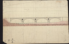
| Description: | Roads and Bridges - Mary Kirk. Plan, elevation of bridge at Mary Kirk. | |
| Place: | Mary Kirk | |
| County: | Forfar ; Kincardine | |
| Subject: | Bridge | |
| Colour: | Colour | |
| Media: | None | |
| Object: | Flat | |
| Physical: | Paper | |
| Size: | 335 x 510 mm | |
| Shelfmark: | Acc.10706, 487 | |
| Show location on map ? | ||
 | ||
| Zoom Into Map: | Click on the map to view in greater detail. | |
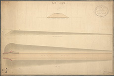
| Name: | Stevenson, Robert, 1772-1850 | |
| Description: | Roads and Bridges - Mary Kirk. Section of the embankment for the bridge at Mary Kirk, signed Robert Stevenson, 1811. | |
| Year: | 1811 | |
| Place: | Mary Kirk | |
| County: | Forfar ; Kincardine | |
| Subject: | Bridge | |
| Colour: | Colour | |
| Media: | Linen/Cloth | |
| Object: | Folded | |
| Physical: | Paper | |
| Size: | 555 x 835 mm | |
| Shelfmark: | Acc.10706, 488 | |
| Show location on map ? | ||
 | ||
| Zoom Into Map: | Click on the map to view in greater detail. | |
| Description: | Marykirk. Section of road to lead from Marykirk Bridge to Montrose and Marykirk roads | |
| Year: | 1812 | |
| Place: | Marykirk | |
| County: | Forfar ; Kincardine | |
| Subject: | Road | |
| Inventory: | Drawing | |
| Colour: | Colour | |
| Media: | Graphite; Hand coloured; Ink | |
| Object: | Folded | |
| Physical: | Paper | |
| Size: | 2675 mm x 635 mm | |
| Shelfmark: | MS.5856, 19 | |
| Show location on map ? | ||