Your placename search for Granton returned 17 records.
Ordered chronologically (undated items first).
| Name: | Stevenson, Robert, 1772-1850 | |
| Description: | Edinburgh: Granton. Small Ox Craig: Survey of Morrison's Haven | |
| Year: | 1825 | |
| Place: | Granton | |
| County: | Edinburgh | |
| Subject: | Reference Material | |
| Inventory: | Drawing | |
| Colour: | Colour | |
| Media: | Hand coloured; Ink | |
| Object: | Folded | |
| Physical: | Paper | |
| Size: | 670 mm x 1170 mm | |
| Shelfmark: | MS.5848, 45 | |
| Show location on map ? | ||
| Name: | Stevenson, Robert, 1772-1850 ; Stevenson, Alan, 1807-1865 | |
| Description: | Edinburgh: Granton. Proposed harbour | |
| Year: | 1834 | |
| Place: | Granton | |
| County: | Edinburgh | |
| Subject: | Harbour | |
| Inventory: | Print by W.H. Lizars | |
| Colour: | Colour | |
| Media: | Hand coloured; Printed | |
| Object: | Folded | |
| Physical: | Paper | |
| Size: | 675 mm x 975 mm | |
| Shelfmark: | MS.5848, 46 | |
| Show location on map ? | ||
| Name: | Stevenson, Robert, 1772-1850 ; Stevenson, Alan, 1807-1865 | |
| Description: | Edinburgh: Granton. Proposed harbour | |
| Year: | 1834 | |
| Place: | Granton | |
| County: | Edinburgh | |
| Subject: | Harbour | |
| Inventory: | Drawing | |
| Shelfmark: | MC.5848, 46A - Map.Rol.d.9 | |
| Show location on map ? | ||
| Name: | Stevenson, Robert, 1772-1850 ; Stevenson, Alan, 1807-1865 | |
| Description: | Edinburgh: Granton. Proposed harbour | |
| Year: | 1834 | |
| Place: | Granton | |
| County: | Edinburgh | |
| Subject: | Harbour | |
| Inventory: | ||
| Colour: | Colour | |
| Media: | Hand coloured; Ink; Printed | |
| Object: | Flat | |
| Physical: | Paper | |
| Size: | 340 mm x 380 mm | |
| Shelfmark: | MS.5848, 47 | |
| Show location on map ? | ||
 | ||
| Zoom Into Map: | Click on the map to view in greater detail. | |
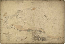
| Description: | Harbours - Granton. MSS Chart of the Firth of Forth from Queensferry to Inchkeith, showing the relative position of the proposed harbour at Granton ... Edinburgh, 1834. | |
| Year: | 1834 | |
| Place: | Granton | |
| County: | Edinburgh | |
| Subject: | Harbour | |
| Colour: | Colour | |
| Media: | Linen/Cloth | |
| Object: | Flat | |
| Physical: | Paper | |
| Size: | 670 x 970 mm | |
| Shelfmark: | Acc.10706, 293 | |
| Show location on map ? | ||
 | ||
| Zoom Into Map: | Click on the map to view in greater detail. | |
| Description: | Harbours - Granton. Chart of the Firth of Forth from Queensferry to Inchkeith, showing the relative position of the proposed harbour at Granton ... Edinburgh, 1834. | |
| Year: | 1834 | |
| Place: | Granton | |
| County: | Edinburgh | |
| Subject: | Harbour | |
| Colour: | B&W | |
| Media: | None | |
| Object: | Flat | |
| Physical: | Paper | |
| Size: | 715 x 1025 mm | |
| Shelfmark: | Acc.10706, 294 | |
| Show location on map ? | ||
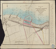
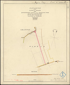
| Name: | Stevenson, Robert, 1772-1850 | |
| Description: | Edinburgh: Granton. Plan of road from Granton Pier to Leith and Queensferry Road | |
| Year: | 1835 | |
| Place: | Granton | |
| County: | Edinburgh | |
| Subject: | Road | |
| Inventory: | Series of 4 drawings | |
| Colour: | Colour | |
| Media: | Hand coloured; Printed | |
| Object: | Flat | |
| Physical: | Paper/Linen/Cloth | |
| Size: | 465 mm x 385 mm | |
| Shelfmark: | MS.5848, 48 | |
| Show location on map ? | ||
 | ||
| Zoom Into Map: | Click on the map to view in greater detail. | |
| Name: | Stevenson, Robert, 1772-1850 | |
| Description: | Edinburgh: Granton. Plan of road from Granton Pier to Leith and Queensferry Road | |
| Year: | 1835 | |
| Place: | Granton | |
| County: | Edinburgh | |
| Subject: | Road | |
| Inventory: | Series of 4 drawings | |
| Colour: | Colour | |
| Media: | Hand coloured; Printed | |
| Object: | Flat | |
| Physical: | Paper | |
| Size: | 410 mm x 345 mm | |
| Shelfmark: | MS.5848, 49 | |
| Show location on map ? | ||
 | ||
| Zoom Into Map: | Click on the map to view in greater detail. | |
| Name: | Stevenson, Robert, 1772-1850 | |
| Description: | Edinburgh: Granton. Plan of road from Granton Pier to Leith and Queensferry Road | |
| Year: | 1835 | |
| Place: | Granton | |
| County: | Edinburgh | |
| Subject: | Road | |
| Inventory: | Series of 4 drawings | |
| Colour: | Colour | |
| Media: | Hand coloured; Printed | |
| Object: | Flat | |
| Physical: | Paper | |
| Size: | 375 mm x 313 mm | |
| Shelfmark: | MS.5848, 50 | |
| Show location on map ? | ||
 | ||
| Zoom Into Map: | Click on the map to view in greater detail. | |
| Name: | Stevenson, Robert, 1772-1850 | |
| Description: | Edinburgh: Granton. Plan of road from Granton Pier to Leith and Queensferry Road | |
| Year: | 1835 | |
| Place: | Granton | |
| County: | Edinburgh | |
| Subject: | Road | |
| Inventory: | Series of 4 drawings | |
| Colour: | Colour | |
| Media: | Hand coloured; Ink | |
| Object: | Flat | |
| Physical: | Paper | |
| Size: | 525 mm x 380 mm | |
| Shelfmark: | MS.5848, 51 | |
| Show location on map ? | ||
 | ||
| Zoom Into Map: | Click on the map to view in greater detail. | |
| Name: | Anderson, James | |
| Description: | Edinburgh: Granton. Sketch plan of Ox Craig | |
| Year: | 1835 | |
| Place: | Granton | |
| County: | Edinburgh | |
| Subject: | Reference Material | |
| Inventory: | Drawing | |
| Colour: | Colour | |
| Media: | Hand coloured; Ink | |
| Object: | Flat | |
| Physical: | Paper | |
| Size: | 670 mm x 768 mm | |
| Shelfmark: | MS.5848, 52 | |
| Show location on map ? | ||
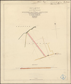
| Name: | Stevenson, Robert, 1772-1850 ; Stevenson, Alan, 1807-1865 | |
| Description: | Edinburgh: Granton. Plan and section of a wharf on the Ox Craig | |
| Year: | 1835 | |
| Place: | Granton | |
| County: | Edinburgh | |
| Subject: | Harbour | |
| Inventory: | Drawing. 2 copies | |
| Colour: | Colour | |
| Media: | Hand coloured; Ink | |
| Object: | Flat | |
| Physical: | Paper/Linen/Cloth | |
| Size: | 685 mm x 960 mm | |
| Shelfmark: | MS.5848, 53 | |
| Show location on map ? | ||
 | ||
| Zoom Into Map: | Click on the map to view in greater detail. | |
| Name: | Stevenson, Robert, 1772-1850 ; Stevenson, Alan, 1807-1865 | |
| Description: | Edinburgh: Granton. Plan and section of a wharf on the Ox Craig | |
| Year: | 1835 | |
| Place: | Granton | |
| County: | Edinburgh | |
| Subject: | Harbour | |
| Inventory: | Drawing. 2 copies | |
| Colour: | Colour | |
| Media: | Hand coloured; Ink | |
| Object: | Flat | |
| Physical: | Paper | |
| Size: | 680 mm x 1004 mm | |
| Shelfmark: | MS.5848, 54 | |
| Show location on map ? | ||
| Description: | Edinburgh: Granton. Plan and section of proposed pier | |
| Year: | 1835 | |
| Place: | Granton | |
| County: | Edinburgh | |
| Subject: | Harbour | |
| Inventory: | Drawing | |
| Colour: | Colour | |
| Media: | Graphite; Hand coloured; Ink | |
| Object: | Folded | |
| Physical: | Paper | |
| Size: | 830 mm x 1091 mm | |
| Shelfmark: | MS.5848, 55 | |
| Show location on map ? | ||
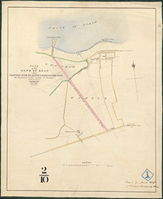
| Name: | Stevenson, Robert, 1772-1850 ; Stevenson, Alan, 1807-1865 | |
| Description: | Edinburgh: Granton. Plan and section of road | |
| Year: | 1836 | |
| Place: | Granton | |
| County: | Edinburgh | |
| Subject: | Road | |
| Inventory: | Drawing | |
| Colour: | Colour | |
| Media: | Hand coloured; Ink | |
| Object: | Flat | |
| Physical: | Paper | |
| Size: | 564 mm x 721 mm | |
| Shelfmark: | MS.5848, 56 | |
| Show location on map ? | ||
 | ||
| Zoom Into Map: | Click on the map to view in greater detail. | |
| Name: | Stevenson, Robert, 1772-1850 ; Stevenson, Alan, 1807-1865 | |
| Description: | Edinburgh: Granton. Sections of Granton Road | |
| Year: | 1837 | |
| Place: | Granton | |
| County: | Edinburgh | |
| Subject: | Road | |
| Inventory: | Drawing | |
| Colour: | Colour | |
| Media: | Hand coloured; Ink | |
| Object: | Flat | |
| Physical: | Paper | |
| Size: | 374 mm x 532 mm | |
| Shelfmark: | MS.5848, 57 | |
| Show location on map ? | ||
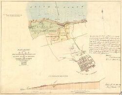
| Description: | Edinburgh: Granton. Plan of district | |
| Year: | 1837 | |
| Place: | Granton | |
| County: | Edinburgh | |
| Subject: | Reference Material | |
| Inventory: | Drawing | |
| Colour: | Colour | |
| Media: | Hand coloured; Ink | |
| Object: | Folded | |
| Physical: | Paper | |
| Size: | 775 mm x 1328 mm | |
| Shelfmark: | MS.5848, 58 | |
| Show location on map ? | ||