Your placename search for Edinburgh returned 170 records.
Ordered chronologically (undated items first).
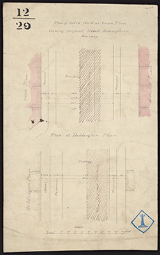
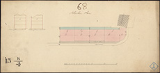
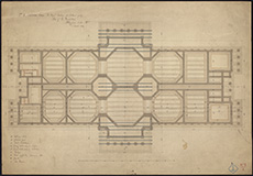
| Description: | Edinburgh: Blinkbonny. Plans of lands | |
| Place: | Edinburgh, Blinkbonny | |
| County: | Edinburgh | |
| Subject: | Reference Material | |
| Inventory: | ||
| Colour: | Colour | |
| Media: | Hand coloured; Printed | |
| Object: | Flat | |
| Physical: | Paper | |
| Size: | 832 mm x 630 mm | |
| Shelfmark: | MS.5848, 6A | |
| Show location on map ? | ||
| Description: | Edinburgh: Bonnington. Gas Works | |
| Place: | Edinburgh, Bonnington | |
| County: | Edinburgh | |
| Subject: | Miscellaneous | |
| Inventory: | Drawing | |
| Colour: | Colour | |
| Media: | Graphite; Hand coloured; Ink | |
| Object: | Flat | |
| Physical: | Paper | |
| Size: | 392 mm x 415 mm | |
| Shelfmark: | MS.5848, 7 | |
| Show location on map ? | ||
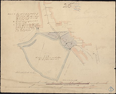
| Description: | Edinburgh: Beechwood & Murrayfield. Sketches of lands | |
| Place: | Edinburgh, Beechwood & Murrayfield | |
| County: | Edinburgh | |
| Subject: | Reference Material | |
| Inventory: | Drawing | |
| Colour: | Colour | |
| Media: | Hand coloured; Ink | |
| Object: | Folded | |
| Physical: | Paper | |
| Size: | 560 mm x 1380 mm | |
| Shelfmark: | MS.5848, 5 | |
| Show location on map ? | ||
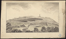
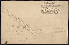
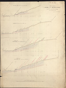
| Description: | Edinburgh: Calton Hill. Sections | |
| Place: | Edinburgh, Calton Hill | |
| County: | Edinburgh | |
| Subject: | Road | |
| Inventory: | Drawing | |
| Colour: | B&W | |
| Media: | Graphite; Ink | |
| Object: | Flat | |
| Physical: | Transparent paper/Linen/Cloth | |
| Size: | 705 mm x 1020 mm | |
| Shelfmark: | MS.5848, 14 | |
| Show location on map ? | ||
| Description: | Edinburgh: Calton Hill. Sketch plan and section of road | |
| Place: | Edinburgh, Calton Hill | |
| County: | Edinburgh | |
| Subject: | Road | |
| Inventory: | Drawing | |
| Colour: | Colour | |
| Media: | Hand coloured; Ink | |
| Object: | Folded | |
| Physical: | Paper | |
| Size: | 580 mm x 1170 mm | |
| Shelfmark: | MS.5848, 15 | |
| Show location on map ? | ||
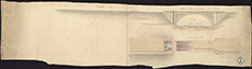
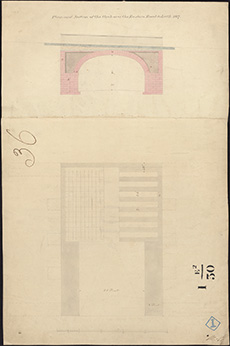
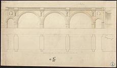
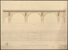
| Description: | Edinburgh: Canonmills. Elevation of proposed stone bridge | |
| Place: | Edinburgh, Canonmills | |
| County: | Edinburgh | |
| Subject: | Bridge | |
| Inventory: | Drawing | |
| Media: | Hand coloured; Ink | |
| Object: | Folded | |
| Physical: | Paper | |
| Size: | 230 mm x 905 mm | |
| Shelfmark: | MS.5848, 23 | |
| Show location on map ? | ||
 | ||
| Zoom Into Map: | Click on the map to view in greater detail. | |
| Description: | Edinburgh: Canonmills. Bridge | |
| Place: | Edinburgh, Canonmills | |
| County: | Edinburgh | |
| Subject: | Bridge | |
| Inventory: | Drawing | |
| Colour: | Colour | |
| Media: | Graphite; Hand coloured; Ink | |
| Object: | Folded | |
| Physical: | Paper | |
| Size: | 574 mm x 1386 mm | |
| Shelfmark: | MS.5848, 24 | |
| Show location on map ? | ||
| Description: | Edinburgh: Canonmills. Section of new road from Dundas Street | |
| Place: | Edinburgh, Canonmills | |
| County: | Edinburgh | |
| Subject: | Road | |
| Inventory: | Drawing | |
| Colour: | Colour | |
| Media: | Graphite; Hand coloured; Ink | |
| Object: | Folded | |
| Physical: | Paper | |
| Size: | 530 mm x 2400 mm | |
| Shelfmark: | MS.5848, 25 | |
| Show location on map ? | ||
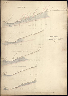
| Description: | Edinburgh: Comely Gardens. Sections of low line of river | |
| Place: | Edinburgh, Comely Gardens | |
| County: | Edinburgh | |
| Subject: | River | |
| Inventory: | Drawing | |
| Colour: | Colour | |
| Media: | Hand coloured; Ink | |
| Object: | Folded | |
| Physical: | Paper | |
| Size: | 388 mm x 1322 mm | |
| Shelfmark: | MS.5848, 27 | |
| Show location on map ? | ||
 | ||
| Zoom Into Map: | Click on the map to view in greater detail. | |
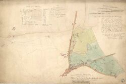
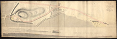
| Description: | Edinburgh: Craigentinny. Plan of estate and sea-shore from Portobello to Leith showing proposed railway | |
| Place: | Edinburgh, Craigentinny | |
| County: | Edinburgh | |
| Subject: | Railway | |
| Inventory: | Drawing | |
| Colour: | Colour | |
| Media: | Hand coloured; Printed | |
| Object: | Flat | |
| Physical: | Paper/Linen/Cloth | |
| Size: | 530 mm x 735 mm | |
| Shelfmark: | MS.5848, 28 | |
| Show location on map ? | ||
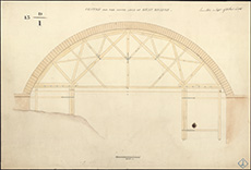
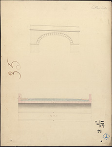
| Description: | Edinburgh: Dean Bridge. Centre for South Arch | |
| Place: | Edinburgh, Dean Bridge | |
| County: | Edinburgh | |
| Subject: | Bridge | |
| Inventory: | Drawing | |
| Colour: | Colour | |
| Media: | Hand coloured; Ink | |
| Object: | Flat | |
| Physical: | Paper | |
| Size: | 484 mm x 718 mm | |
| Shelfmark: | MS.5848, 34 | |
| Show location on map ? | ||
 | ||
| Zoom Into Map: | Click on the map to view in greater detail. | |
| Description: | Edinburgh: Easter Road. Survey of Baron Norton's feu | |
| Place: | Edinburgh, Easter Road | |
| County: | Edinburgh | |
| Subject: | Reference Material | |
| Inventory: | Drawing | |
| Colour: | Colour | |
| Media: | Hand coloured; Ink | |
| Object: | Flat | |
| Physical: | Paper/Linen/Cloth | |
| Size: | 560 mm x 835 mm | |
| Shelfmark: | MS.5848, 42 | |
| Show location on map ? | ||
 | ||
| Zoom Into Map: | Click on the map to view in greater detail. | |
| Description: | Edinburgh: Easter Road. Proposed bridge | |
| Place: | Edinburgh, Easter Road | |
| County: | Edinburgh | |
| Subject: | Bridge | |
| Inventory: | Drawing | |
| Colour: | Colour | |
| Media: | Hand coloured; Ink | |
| Object: | Flat | |
| Physical: | Paper | |
| Size: | 336 mm x 253 mm | |
| Shelfmark: | MS.5848, 43 | |
| Show location on map ? | ||
 | ||
| Zoom Into Map: | Click on the map to view in greater detail. | |
| Description: | Edinburgh, London Road. Sections through lands of Hillside | |
| Place: | Edinburgh, London Road | |
| County: | Edinburgh | |
| Subject: | Road | |
| Inventory: | Drawing | |
| Colour: | Colour | |
| Media: | Hand coloured; Ink | |
| Object: | Flat | |
| Physical: | Paper | |
| Size: | 564 mm x 1032 mm | |
| Shelfmark: | MS.5849, 9 | |
| Show location on map ? | ||
| Description: | Edinburgh, North Bridge. Alteration to be made | |
| Place: | Edinburgh, North Bridge | |
| County: | Edinburgh | |
| Subject: | Bridge | |
| Inventory: | Drawing | |
| Colour: | Colour | |
| Media: | Hand coloured; Ink | |
| Object: | Folded | |
| Physical: | Paper/Linen/Cloth | |
| Size: | 530 mm x 708 mm | |
| Shelfmark: | MS.5849, 45 | |
| Show location on map ? | ||
| Description: | Edinburgh, Princes Street. Sketch of East End with proposed alterations | |
| Place: | Edinburgh, Princes Street | |
| County: | Edinburgh | |
| Subject: | Road | |
| Inventory: | Drawing | |
| Colour: | Colour | |
| Media: | Hand coloured; Ink | |
| Object: | Flat | |
| Physical: | Paper | |
| Size: | 325 mm x 535 mm | |
| Shelfmark: | MS.5849, 50 | |
| Show location on map ? | ||
 | ||
| Zoom Into Map: | Click on the map to view in greater detail. | |
| Description: | Edinburgh, Regent Road. Section | |
| Place: | Edinburgh, Regent Road | |
| County: | Edinburgh | |
| Subject: | Road | |
| Inventory: | Drawing | |
| Colour: | Colour | |
| Media: | Hand coloured; Ink | |
| Object: | Flat | |
| Physical: | Paper | |
| Size: | 572 mm x 845 mm | |
| Shelfmark: | MS.5849, 58 | |
| Show location on map ? | ||
| Description: | Edinburgh, Regent Road. Section from Jock's Lodge to Baron Norton's Gate | |
| Place: | Edinburgh, Regent Road | |
| County: | Edinburgh | |
| Subject: | Road | |
| Inventory: | Drawing | |
| Colour: | B&W | |
| Media: | Graphite; Ink | |
| Object: | Folded | |
| Physical: | Paper | |
| Size: | 775 mm x 1980 mm | |
| Shelfmark: | MS.5849, 59 | |
| Show location on map ? | ||
| Description: | Edinburgh, Regent Road. Sections | |
| Place: | Edinburgh, Regent Road | |
| County: | Edinburgh | |
| Subject: | Road | |
| Inventory: | Series of 5 drawings | |
| Colour: | Colour | |
| Media: | Hand coloured; Ink | |
| Object: | Folded | |
| Physical: | Paper | |
| Size: | 530 mm x 2620 mm | |
| Shelfmark: | MS.5849, 60 | |
| Show location on map ? | ||
| Description: | Edinburgh, Regent Road. Copy of Parliamentary Plan | |
| Place: | Edinburgh, Regent Road | |
| County: | Edinburgh | |
| Subject: | Road | |
| Inventory: | Drawing | |
| Colour: | B&W | |
| Media: | Graphite; Ink | |
| Object: | Flat | |
| Physical: | Paper | |
| Size: | 320 mm x 205 mm | |
| Shelfmark: | MS.5849, 65 | |
| Show location on map ? | ||
 | ||
| Zoom Into Map: | Click on the map to view in greater detail. | |
| Description: | Edinburgh, Regent Road. East End of Princes Street showing Regent Bridge | |
| Place: | Edinburgh, Regent Road | |
| County: | Edinburgh | |
| Subject: | Road | |
| Inventory: | Drawing | |
| Colour: | Colour | |
| Media: | Hand coloured; Ink | |
| Object: | Folded | |
| Physical: | Paper | |
| Size: | 580 mm x 1292 mm | |
| Shelfmark: | MS.5849, 66 | |
| Show location on map ? | ||
 | ||
| Zoom Into Map: | Click on the map to view in greater detail. | |
| Description: | Edinburgh, Regent Road. Sketches of proposed new buildings | |
| Place: | Edinburgh, Regent Road | |
| County: | Edinburgh | |
| Subject: | Road | |
| Inventory: | Series of 2 drawings | |
| Colour: | Colour | |
| Media: | Hand coloured; Ink | |
| Object: | Flat | |
| Physical: | Paper | |
| Size: | 330 mm x 561 mm | |
| Shelfmark: | MS.5849, 67 | |
| Show location on map ? | ||
 | ||
| Zoom Into Map: | Click on the map to view in greater detail. | |
| Description: | Edinburgh, Regent Road. Section of Windsor Street and Leopold | |
| Place: | Edinburgh, Regent Road | |
| County: | Edinburgh | |
| Subject: | Road | |
| Inventory: | Drawing | |
| Colour: | Colour | |
| Media: | Hand coloured; Ink | |
| Object: | Flat | |
| Physical: | Paper | |
| Size: | 535 mm x 635 mm | |
| Shelfmark: | MS.5849, 69 | |
| Show location on map ? | ||
| Description: | Edinburgh, Railways. Plan of Leith at Union Place showing proposed Direct Atmospheric Railway | |
| Place: | Edinburgh, Union Place | |
| County: | Edinburgh | |
| Subject: | Railway | |
| Inventory: | Drawing | |
| Colour: | Colour | |
| Media: | Hand coloured; Ink | |
| Object: | Flat | |
| Physical: | Paper | |
| Size: | 304 mm x 190 mm | |
| Shelfmark: | MS.5849, 90 | |
| Show location on map ? | ||
 | ||
| Zoom Into Map: | Click on the map to view in greater detail. | |
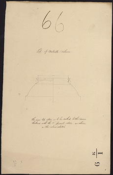
| Description: | Lord Melville's Monument. Section of base of the Melville Monument, endorsed no.27 (deleted) | |
| Place: | Edinburgh, Melville's Monument | |
| County: | Edinburgh | |
| Subject: | Building/Monument | |
| Colour: | B&W | |
| Media: | None | |
| Object: | Flat | |
| Physical: | Paper | |
| Size: | 530 x 635 mm | |
| Shelfmark: | Acc.10706, 359 | |
| Show location on map ? | ||
 | ||
| Zoom Into Map: | Click on the map to view in greater detail. | |
| Description: | Lord Melville's Monument. Section of base of the Melville Monument, endorsed no.28 (deleted) | |
| Place: | Edinburgh, Melville's Monument | |
| County: | Edinburgh | |
| Subject: | Building/Monument | |
| Colour: | B&W | |
| Media: | None | |
| Object: | Flat | |
| Physical: | Paper | |
| Size: | 530 x 635 mm | |
| Shelfmark: | Acc.10706, 360 | |
| Show location on map ? | ||
 | ||
| Zoom Into Map: | Click on the map to view in greater detail. | |
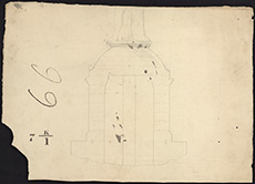
| Description: | Lord Melville's Monument. Drawing of the top of the Melville column. | |
| Place: | Edinburgh, Melville's Monument | |
| County: | Edinburgh | |
| Subject: | Building/Monument | |
| Colour: | B&W | |
| Media: | None | |
| Object: | Flat | |
| Physical: | Card | |
| Size: | 535 x 332 mm | |
| Shelfmark: | Acc.10706, 361 | |
| Show location on map ? | ||
 | ||
| Zoom Into Map: | Click on the map to view in greater detail. | |
| Description: | Lord Melville's Monument. Elevation of base of Melville's Monument, endorsed no.29 (deleted) | |
| Place: | Edinburgh, Melville's Monument | |
| County: | Edinburgh | |
| Subject: | Building/Monument | |
| Colour: | B&W | |
| Media: | None | |
| Object: | Flat | |
| Physical: | Paper | |
| Size: | 375 x 535 mm | |
| Shelfmark: | Acc.10706, 362 | |
| Show location on map ? | ||
 | ||
| Zoom Into Map: | Click on the map to view in greater detail. | |
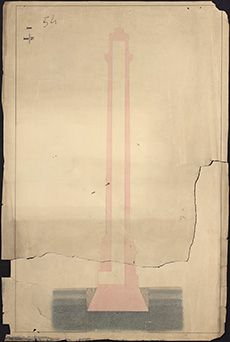
| Description: | Lord Melville's Monument. Section of column and foundations of Melville's Monument. (torn in two unequal parts) | |
| Place: | Edinburgh, Melville's Monument | |
| County: | Edinburgh | |
| Subject: | Building/Monument | |
| Colour: | Colour | |
| Media: | None | |
| Object: | Flat | |
| Physical: | Paper | |
| Size: | 1000 x 660 mm | |
| Shelfmark: | Acc.10706, 363 | |
| Show location on map ? | ||
 | ||
| Zoom Into Map: | Click on the map to view in greater detail. | |
| Description: | Lord Melville's Monument. Sections and plans for the base of the Melville Monument endorsed no.30 (deleted) | |
| Place: | Edinburgh, Melville's Monument | |
| County: | Edinburgh | |
| Subject: | Building/Monument | |
| Colour: | B&W | |
| Media: | None | |
| Object: | Flat | |
| Physical: | Paper | |
| Size: | 635 x 530 mm | |
| Shelfmark: | Acc.10706, 364 | |
| Show location on map ? | ||
| Name: | Gordon, James, 1615?-1686 ; Stevenson, David Alan, 1854-1938 | |
| Description: | . Section of Rothemay's plan of Edinburgh, 1647 copied by DAS. | |
| Place: | Edinburgh | |
| County: | Edinburgh | |
| Subject: | Reference Material | |
| Colour: | B&W | |
| Media: | None | |
| Object: | Flat | |
| Physical: | Paper | |
| Size: | 195 x 250 mm | |
| Shelfmark: | Acc.10706, 382 | |
| Show location on map ? | ||
 | ||
| Zoom Into Map: | Click on the map to view in greater detail. | |
| Name: | Stevenson, Robert, 1772-1850 | |
| Description: | Roads and Bridges - Edinburgh. Sketch showing the western line of approach to the City of Edinburgh proposed by Mr Stevenson, n.d. | |
| Place: | Edinburgh, Calton Hill | |
| County: | Edinburgh | |
| Subject: | Road | |
| Colour: | Colour | |
| Media: | None | |
| Object: | Flat | |
| Physical: | Paper | |
| Size: | 145 x 240 mm | |
| Shelfmark: | Acc.10706, 462 | |
| Show location on map ? | ||
 | ||
| Zoom Into Map: | Click on the map to view in greater detail. | |
| Description: | Roads and Bridges - Edinburgh. Plan of the northern part of the south approach by the Bank Street Line, showing also the position of the proposed East Line, n.d. | |
| Place: | Edinburgh, Bank Street | |
| County: | Edinburgh | |
| Subject: | Road | |
| Colour: | Colour | |
| Media: | None | |
| Object: | Flat | |
| Physical: | Paper | |
| Size: | 450 x 560 mm | |
| Shelfmark: | Acc.10706, 463 | |
| Show location on map ? | ||
 | ||
| Zoom Into Map: | Click on the map to view in greater detail. | |
| Description: | Roads and Bridges - Edinburgh. Reduced lithograph copy of 466. | |
| Place: | Edinburgh, Grassmarket | |
| County: | Edinburgh | |
| Subject: | Road | |
| Colour: | Colour | |
| Media: | None | |
| Object: | Flat | |
| Physical: | Paper | |
| Size: | 275 x 750 mm | |
| Shelfmark: | Acc.10706, 467 | |
| Show location on map ? | ||
 | ||
| Zoom Into Map: | Click on the map to view in greater detail. | |
| Description: | Roads and Bridges - Edinburgh. Map: description of property and owners names on the line of Bridge from Shakespeare Square to Calton Burying Ground, n.d. | |
| Place: | Edinburgh, Calton Hill | |
| County: | Edinburgh | |
| Subject: | Bridge | |
| Colour: | B&W | |
| Media: | None | |
| Object: | Flat | |
| Physical: | Paper | |
| Size: | 320 x 630 mm | |
| Shelfmark: | Acc.10706, 468 | |
| Show location on map ? | ||
 | ||
| Zoom Into Map: | Click on the map to view in greater detail. | |
| Description: | Roads and Bridges - Edinburgh. MS plan for a new road or street from the Muscleburgh road, at or near Jocks Lodge to Princes Street, Edinburgh. [Regent Terrace] s.l.s.d. | |
| Place: | Edinburgh, Princes Street | |
| County: | Edinburgh | |
| Subject: | Road | |
| Colour: | Colour | |
| Media: | Linen/Cloth | |
| Object: | Folded | |
| Physical: | Paper | |
| Size: | 750 x 2300 mm | |
| Shelfmark: | Acc.10706, 470 | |
| Show location on map ? | ||
 | ||
| Zoom Into Map: | Click on the map to view in greater detail. | |
| Description: | Experiments in Queen's Park. Section of ground at Salisbury Crags - vertical divergence. | |
| Place: | Edinburgh, Holyrood Park | |
| County: | Edinburgh | |
| Subject: | Machinery | |
| Colour: | Colour | |
| Media: | Linen/Cloth | |
| Object: | Flat | |
| Physical: | Paper | |
| Size: | 230 x 370 mm | |
| Shelfmark: | Acc.10706, 622 | |
| Show location on map ? | ||
 | ||
| Zoom Into Map: | Click on the map to view in greater detail. | |
| Description: | Experiments in Queen's Park. Photometrical experiment on Salisbury Crags - vertical divergence of light. | |
| Place: | Edinburgh, Holyrood Park | |
| County: | Edinburgh | |
| Subject: | Machinery | |
| Colour: | B&W | |
| Media: | Linen/Cloth | |
| Object: | Flat | |
| Physical: | Transparent paper | |
| Size: | 245 x 370 mm | |
| Shelfmark: | Acc.10706, 623 | |
| Show location on map ? | ||
 | ||
| Zoom Into Map: | Click on the map to view in greater detail. | |
| Description: | Edinburgh, Regent Road. Sections | |
| Place: | Edinburgh, Regent Road | |
| County: | Edinburgh | |
| Subject: | Road | |
| Inventory: | Series of 5 drawings | |
| Colour: | Colour | |
| Media: | Graphite; Hand coloured; Ink | |
| Object: | Folded | |
| Physical: | Paper | |
| Size: | 540 mm x 2610 mm | |
| Shelfmark: | MS.5849, 61 | |
| Description: | Edinburgh, Regent Road. Sections | |
| Place: | Edinburgh, Regent Road | |
| County: | Edinburgh | |
| Subject: | Road | |
| Inventory: | Series of 5 drawings | |
| Colour: | Colour | |
| Media: | Graphite; Hand coloured; Ink | |
| Object: | Folded | |
| Physical: | Paper | |
| Size: | 430 mm x 4750 mm | |
| Shelfmark: | MS.5849, 62 | |
| Description: | Edinburgh, Regent Road. Sections | |
| Place: | Edinburgh, Regent Road | |
| County: | Edinburgh | |
| Subject: | Road | |
| Inventory: | Series of 5 drawings | |
| Colour: | Colour | |
| Media: | Graphite; Hand coloured; Ink | |
| Object: | Folded | |
| Physical: | Paper | |
| Size: | 573 mm x 1355 mm | |
| Shelfmark: | MS.5849, 63 | |
| Description: | Edinburgh, Regent Road. Sections | |
| Place: | Edinburgh, Regent Road | |
| County: | Edinburgh | |
| Subject: | Road | |
| Inventory: | Series of 5 drawings | |
| Colour: | Colour | |
| Media: | Graphite; Hand coloured; Ink | |
| Object: | Folded | |
| Physical: | Paper | |
| Size: | 325 mm x 1050 mm | |
| Shelfmark: | MS.5849, 64 | |
| Description: | Edinburgh, Regent Road. Sketches of proposed new buildings | |
| Place: | Edinburgh, Regent Road | |
| County: | Edinburgh | |
| Subject: | Road | |
| Inventory: | Series of 2 drawings | |
| Colour: | Colour | |
| Media: | Hand coloured; Ink | |
| Object: | Flat | |
| Physical: | Paper | |
| Size: | 350 mm x 535 mm | |
| Shelfmark: | MS.5849, 68 | |
 | ||
| Zoom Into Map: | Click on the map to view in greater detail. | |
| Description: | Edinburgh. Sketch showing the improvements to the Stockbridge Road. | |
| Place: | Edinburgh | |
| County: | Edinburgh | |
| Subject: | Road | |
| Colour: | Colour | |
| Media: | None | |
| Object: | Folded | |
| Physical: | Paper | |
| Size: | 260 x 12770 mm | |
| Shelfmark: | Acc.10706, 683 | |
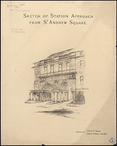
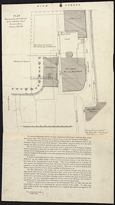
| Description: | St Andrew Square. Sketch of Station Approach from St Andrew Square' [Proposed design of Caledonian Station Entrance - from Ruthland Street] Architects: Frank W. Simon and Henry F. Kerr | |
| Place: | Edinburgh, St Andrew Square | |
| County: | Edinburgh | |
| Subject: | Building/Monument | |
| Shelfmark: | MS.5896, 6 | |
 | ||
| Zoom Into Map: | Click on the map to view in greater detail. | |
| Name: | Mylne, William 1734-1790 | |
| Description: | Edinburgh, North Bridge. Elevation | |
| Year: | 1770 | |
| Place: | Edinburgh, North Bridge | |
| County: | Edinburgh | |
| Subject: | Bridge | |
| Inventory: | Drawing | |
| Colour: | Colour | |
| Media: | Hand coloured; Ink | |
| Object: | Flat | |
| Physical: | Paper | |
| Size: | 310 mm x 978 mm | |
| Shelfmark: | MS.5849, 23 | |
| Show location on map ? | ||
| Name: | Mylne, William 1734-1790 | |
| Description: | Edinburgh, North Bridge. Sketch | |
| Year: | 1770 | |
| Place: | Edinburgh, North Bridge | |
| County: | Edinburgh | |
| Subject: | Bridge | |
| Inventory: | Drawing | |
| Colour: | Colour | |
| Media: | Graphite; Hand coloured; Ink | |
| Object: | Flat | |
| Physical: | Paper | |
| Size: | 315 mm x 500 mm | |
| Shelfmark: | MS.5849, 24 | |
| Show location on map ? | ||
 | ||
| Zoom Into Map: | Click on the map to view in greater detail. | |
| Description: | . Plan of Bridewell Prison, endorsed Edinburgh the Fourteinth June 1792. | |
| Year: | 1792 | |
| Place: | Edinburgh | |
| County: | Edinburgh | |
| Subject: | Building/Monument | |
| Colour: | Colour | |
| Media: | None | |
| Object: | Flat | |
| Physical: | Paper | |
| Size: | 770 x 625 mm | |
| Shelfmark: | Acc.10706, 397 | |
| Show location on map ? | ||
| Description: | Calton Jail. Calton Jail c. 1800 | |
| Year: | 1800 | |
| Place: | Edinburgh, Calton Jail | |
| County: | Edinburgh | |
| Subject: | Building/Monument | |
| Shelfmark: | MS.5896, 11 | |
 | ||
| Zoom Into Map: | Click on the map to view in greater detail. | |
| Name: | Playfair, William Henry, 1790-1857 | |
| Description: | Edinburgh: Elm Row. Plan of block of buildings between Elm Row, Leopold Place, Windsor Street and Montgomery Street | |
| Year: | 1811 | |
| Place: | Edinburgh, Elm Row | |
| County: | Edinburgh | |
| Subject: | Building/Monument | |
| Inventory: | Drawing | |
| Colour: | Colour | |
| Media: | Graphite; Hand coloured; Ink | |
| Object: | Flat | |
| Physical: | Paper | |
| Size: | 655 mm x 460 mm | |
| Shelfmark: | MS.5848, 44 | |
| Show location on map ? | ||
 | ||
| Zoom Into Map: | Click on the map to view in greater detail. | |
| Description: | . Sketch of a plan and section of ground for a new Justiciary Courthouse and prison, on paper watermarked 1812(?) | |
| Year: | 1812 | |
| Place: | Edinburgh | |
| County: | Edinburgh | |
| Subject: | Building/Monument | |
| Colour: | Colour | |
| Media: | None | |
| Object: | Flat | |
| Physical: | Paper | |
| Size: | 525 x 640 mm | |
| Shelfmark: | Acc.10706, 394 | |
| Show location on map ? | ||
 | ||
| Zoom Into Map: | Click on the map to view in greater detail. | |
| Description: | . Plan of Bridewell Prison (Calton) on paper watermarked 1812(?) | |
| Year: | 1812 | |
| Place: | Edinburgh | |
| County: | Edinburgh | |
| Subject: | Building/Monument | |
| Colour: | Colour | |
| Media: | None | |
| Object: | Flat | |
| Physical: | Paper | |
| Size: | 520 x 640 mm | |
| Shelfmark: | Acc.10706, 395 | |
| Show location on map ? | ||
 | ||
| Zoom Into Map: | Click on the map to view in greater detail. | |
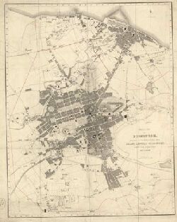
| Name: | Knox, James | |
| Description: | Edinburgh. Map of shire of Edinburgh | |
| Year: | 1812 | |
| Place: | Edinburgh | |
| County: | Edinburgh | |
| Subject: | Reference Material | |
| Inventory: | Prrinted by Neele, London | |
| Colour: | Colour | |
| Media: | Hand coloured; Printed | |
| Object: | Flat | |
| Physical: | Paper | |
| Size: | 675 mm x 790 mm | |
| Shelfmark: | MS.5849, 101 | |
| Show location on map ? | ||
| Name: | Stevenson, Robert, 1772-1850 | |
| Description: | Edinburgh: Canonmills. Design for bridge | |
| Year: | 1813 | |
| Place: | Edinburgh, Canonmills | |
| County: | Edinburgh | |
| Subject: | Bridge | |
| Inventory: | Drawing | |
| Colour: | B&W | |
| Media: | Graphite | |
| Object: | Flat | |
| Physical: | Paper | |
| Size: | 555 mm x 445 mm | |
| Shelfmark: | MS.5848, 17 | |
| Show location on map ? | ||
| Name: | Stevenson, Robert, 1772-1850 | |
| Description: | Roads and Bridges - Edinburgh. Survey of the lands of Calton Hill and design for a new approach to the City of Edinburgh...signed Robert Stevenson, 1814. | |
| Year: | 1814 | |
| Place: | Edinburgh, Calton Hill | |
| County: | Edinburgh | |
| Subject: | Road | |
| Colour: | Colour | |
| Media: | Linen/Cloth | |
| Object: | Folded | |
| Physical: | Paper | |
| Size: | 755 x 1280 mm | |
| Shelfmark: | Acc.10706, 464 | |
| Show location on map ? | ||
| Name: | Stevenson, Robert, 1772-1850 | |
| Description: | Roads and Bridges - Edinburgh. Plan of the lands of Calton Hill and design for a new approach to the City of Edinburgh by a bridge over Calton Street. Robert Stevenson, 1814. | |
| Year: | 1814 | |
| Place: | Edinburgh, Calton Hill | |
| County: | Edinburgh | |
| Subject: | Road | |
| Colour: | Colour | |
| Media: | Linen/Cloth | |
| Object: | Folded | |
| Physical: | Paper | |
| Size: | 650 x 990 mm | |
| Shelfmark: | Acc.10706, 465 | |
| Show location on map ? | ||
 | ||
| Zoom Into Map: | Click on the map to view in greater detail. | |
| Description: | Edinburgh: Canonmills. Bridge over mill-land at Canonmills meadow | |
| Year: | 1815 | |
| Place: | Edinburgh, Canonmills | |
| County: | Edinburgh | |
| Subject: | Bridge | |
| Inventory: | Drawing | |
| Colour: | Colour | |
| Media: | Hand coloured; Ink | |
| Object: | Folded | |
| Physical: | Paper | |
| Size: | 595 mm x 1065 mm | |
| Shelfmark: | MS.5848, 18 | |
| Show location on map ? | ||
| Description: | Edinburgh: Calton Hill. Sketch, plan and section of road | |
| Year: | 1815 | |
| Place: | Edinburgh, Calton Hill | |
| County: | Edinburgh | |
| Subject: | Road | |
| Inventory: | Drawing | |
| Colour: | Colour | |
| Media: | Graphite; Hand coloured; Ink | |
| Object: | Folded | |
| Physical: | Paper | |
| Size: | 534 mm x 2175 mm | |
| Shelfmark: | MS.5848, 8 | |
| Show location on map ? | ||
 | ||
| Zoom Into Map: | Click on the map to view in greater detail. | |
| Description: | Edinburgh: Calton Hill. Section of road | |
| Year: | 1815 | |
| Place: | Edinburgh, Calton Hill | |
| County: | Edinburgh | |
| Subject: | Road | |
| Inventory: | Drawing | |
| Colour: | Colour | |
| Media: | Graphite; Hand coloured; Ink | |
| Object: | Folded | |
| Physical: | Paper | |
| Size: | 530 mm x 2090 mm | |
| Shelfmark: | MS.5848, 9 | |
| Show location on map ? | ||
| Description: | Regent Road. Retaining Wall, Regent Road, Edinburgh (Trotter's Workshop & yard.) Watermark: W. Spear 1815 | |
| Year: | 1815 | |
| Place: | Edinburgh, Regent Road | |
| County: | Edinburgh | |
| Subject: | Road | |
| Shelfmark: | MS.5896, 1 | |
| Description: | Edinburgh: Canonmills. Sketch, plan and sections of bridge and part of new road by Dundas Street | |
| Year: | 1816 | |
| Place: | Edinburgh, Canonmills | |
| County: | Edinburgh | |
| Subject: | Bridge | |
| Inventory: | Drawing | |
| Colour: | Colour | |
| Media: | Hand coloured; Ink | |
| Object: | Flat | |
| Physical: | Paper | |
| Size: | 530 mm x 807 mm | |
| Shelfmark: | MS.5848, 19 | |
| Show location on map ? | ||
| Name: | Stevenson (unspecified) | |
| Description: | Edinburgh: Easter Road. Survey | |
| Year: | 1816 | |
| Place: | Edinburgh, Easter Road | |
| County: | Edinburgh | |
| Subject: | Reference Material | |
| Inventory: | Drawing | |
| Colour: | Colour | |
| Media: | Hand coloured; Ink | |
| Object: | Flat | |
| Physical: | Paper/Linen/Cloth | |
| Size: | 510 mm x 1395 mm | |
| Shelfmark: | MS.5848, 36 | |
| Show location on map ? | ||
 | ||
| Zoom Into Map: | Click on the map to view in greater detail. | |
| Description: | Edinburgh: Easter Road. Plan and section of bridge | |
| Year: | 1816 | |
| Place: | Edinburgh, Easter Road | |
| County: | Edinburgh | |
| Subject: | Bridge | |
| Inventory: | Drawing | |
| Colour: | Colour | |
| Media: | Hand coloured; Ink | |
| Object: | Flat | |
| Physical: | Paper | |
| Size: | 647 mm x 526 mm | |
| Shelfmark: | MS.5848, 37 | |
| Show location on map ? | ||
 | ||
| Zoom Into Map: | Click on the map to view in greater detail. | |
| Description: | . Ground plan of the City of Edinburgh's Property on the North Side of the Town. 1816. | |
| Year: | 1816 | |
| Place: | Edinburgh | |
| County: | Edinburgh | |
| Subject: | Reference Material | |
| Colour: | Colour | |
| Media: | None | |
| Object: | Flat | |
| Physical: | Paper | |
| Size: | 415 x 675 mm | |
| Shelfmark: | Acc.10706, 391 | |
| Show location on map ? | ||
 | ||
| Zoom Into Map: | Click on the map to view in greater detail. | |
| Description: | Drains. Sections showing drains and tunnel in the Grass Market, Earthen Mound and Burying Ground, on paper watermarked 1816(?) | |
| Year: | 1816 | |
| Place: | Edinburgh, Grassmarket | |
| County: | Edinburgh | |
| Subject: | Water Supply Works | |
| Colour: | Colour | |
| Media: | None | |
| Object: | Folded | |
| Physical: | Paper | |
| Size: | 345 x 1650 mm | |
| Shelfmark: | Acc.10706, 288 | |
| Show location on map ? | ||
| Name: | Kirkwood, Robert | |
| Description: | Edinburgh. City of Edinburgh and its environs | |
| Year: | 1817 | |
| Place: | Edinburgh | |
| County: | Edinburgh | |
| Subject: | Reference Material | |
| Inventory: | Print by Eaden, London | |
| Colour: | Colour | |
| Media: | Hand coloured; Printed | |
| Object: | Folded | |
| Physical: | Paper/Linen/Cloth | |
| Size: | 1640 mm x 1460 mm | |
| Shelfmark: | MS.5849, 104 | |
| Show location on map ? | ||
| Name: | Stevenson, Robert, 1772-1850 | |
| Description: | Roads and Bridges - Edinburgh. Plan of Princes Street and Regent Street signed Robert Stevenson, 1817. | |
| Year: | 1817 | |
| Place: | Edinburgh, Princes Street | |
| County: | Edinburgh | |
| Subject: | Road | |
| Colour: | Colour | |
| Media: | None | |
| Object: | Folded | |
| Physical: | Paper | |
| Size: | 285 x 3200 mm | |
| Shelfmark: | Acc.10706, 469 | |
| Show location on map ? | ||
 | ||
| Zoom Into Map: | Click on the map to view in greater detail. | |
| Description: | Edinburgh: Easter Road. Arch over road | |
| Year: | 1817 | |
| Place: | Edinburgh, Easter Road | |
| County: | Edinburgh | |
| Subject: | Bridge | |
| Inventory: | Series of 2 drawings | |
| Colour: | Colour | |
| Media: | Hand coloured; Ink | |
| Object: | Flat | |
| Physical: | Paper | |
| Size: | 668 mm x 440 mm | |
| Shelfmark: | MS.5848, 38 | |
| Show location on map ? | ||
 | ||
| Zoom Into Map: | Click on the map to view in greater detail. | |
| Description: | Edinburgh: Easter RoadMidlothian. Arch over road | |
| Year: | 1817 | |
| Place: | Edinburgh, Easter Road | |
| County: | Edinburgh | |
| Subject: | Bridge | |
| Inventory: | Series of 2 drawings | |
| Colour: | Colour | |
| Media: | Hand coloured; Ink | |
| Object: | Flat | |
| Physical: | Paper | |
| Size: | 590 mm x 451 mm | |
| Shelfmark: | MS.5848, 39 | |
| Show location on map ? | ||
 | ||
| Zoom Into Map: | Click on the map to view in greater detail. | |
| Description: | Edinburgh: Easter RoadMidlothian. Sketch plan and section showing proposed improvements at the Quarry Holes | |
| Year: | 1817 | |
| Place: | Edinburgh, Easter Road | |
| County: | Edinburgh | |
| Subject: | Building/Monument | |
| Inventory: | Drawing | |
| Colour: | Colour | |
| Media: | Graphite; Hand coloured; Ink | |
| Object: | Flat | |
| Physical: | Paper | |
| Size: | 540 mm x 820 mm | |
| Shelfmark: | MS.5848, 40 | |
| Show location on map ? | ||
 | ||
| Zoom Into Map: | Click on the map to view in greater detail. | |
| Description: | Edinburgh, London Road. Sections through lands of Hillside | |
| Year: | 1817 | |
| Place: | Edinburgh, London Road | |
| County: | Edinburgh | |
| Subject: | Road | |
| Inventory: | Drawing | |
| Colour: | Colour | |
| Media: | Hand coloured; Ink | |
| Object: | Flat | |
| Physical: | Paper | |
| Size: | 655 mm x 1040 mm | |
| Shelfmark: | MS.5849, 1 | |
| Show location on map ? | ||
| Description: | Edinburgh, Powderhall. Lands belonging to Capt. McDonald | |
| Year: | 1819 | |
| Place: | Edinburgh, Powderhall | |
| County: | Edinburgh | |
| Subject: | Reference Material | |
| Inventory: | Drawing, copied from survey by Mylne of 1784 | |
| Colour: | B&W | |
| Media: | Ink | |
| Object: | Flat | |
| Physical: | Paper | |
| Size: | 530 mm x 795 mm | |
| Shelfmark: | MS.5849, 51 | |
| Show location on map ? | ||
 | ||
| Zoom Into Map: | Click on the map to view in greater detail. | |
| Description: | Edinburgh, Powderhall. Section relative to Bonnington Mills | |
| Year: | 1819 | |
| Place: | Edinburgh, Powderhall | |
| County: | Edinburgh | |
| Subject: | Building/Monument | |
| Inventory: | Series of 2 drawings | |
| Colour: | Colour | |
| Media: | Graphite; Hand coloured; Ink | |
| Object: | Folded | |
| Physical: | Paper | |
| Size: | 325 mm x 1052 mm | |
| Shelfmark: | MS.5849, 52-53 | |
| Show location on map ? | ||
| Name: | M.S. | |
| Description: | Edinburgh, Regent Road. Section of Tunnel under new road by Jock's Lodge | |
| Year: | 1819 | |
| Place: | Edinburgh, Regent Road | |
| County: | Edinburgh | |
| Subject: | Road | |
| Inventory: | Series of 4 drawings | |
| Colour: | Colour | |
| Media: | Graphite; Hand coloured; Ink | |
| Object: | Flat | |
| Physical: | Paper | |
| Size: | 510 mm x 640 mm | |
| Shelfmark: | MS.5849, 54-57 | |
| Show location on map ? | ||
 | ||
| Zoom Into Map: | Click on the map to view in greater detail. | |
| Name: | Stevenson, Robert, 1772-1850 | |
| Description: | Edinburgh: Calton Hill. Sketch showing proposed feuing of lands of Heriot's Hospital | |
| Year: | 1819 | |
| Place: | Edinburgh, Calton Hill | |
| County: | Edinburgh | |
| Subject: | Road | |
| Inventory: | Drawing | |
| Colour: | Colour | |
| Media: | Hand coloured; Ink | |
| Object: | Flat | |
| Physical: | Paper | |
| Size: | 576 mm x 845 mm | |
| Shelfmark: | MS.5848, 10 | |
| Show location on map ? | ||
| Description: | . Mr Stevenson's office sketch of part of the City of Edinburgh and extended Royalty, 1819. [E-W plan from Maitland Street to Jocks Lodge and from Queen Street south to Greyfriars Kirk] | |
| Year: | 1819 | |
| Place: | Edinburgh | |
| County: | Edinburgh | |
| Subject: | Reference Material | |
| Colour: | Colour | |
| Media: | Linen/Cloth | |
| Object: | Folded | |
| Physical: | Paper | |
| Size: | 760 x 3200 mm | |
| Shelfmark: | Acc.10706, 392 | |
| Show location on map ? | ||
 | ||
| Zoom Into Map: | Click on the map to view in greater detail. | |
| Description: | Edinburgh. Sketch showing the present and proposed roads from Stockbridge to Edinburgh, 1819 | |
| Year: | 1819 | |
| Place: | Edinburgh | |
| County: | Edinburgh | |
| Subject: | Road | |
| Colour: | Colour | |
| Media: | None | |
| Object: | Flat | |
| Physical: | Card | |
| Size: | 490 x 485 mm | |
| Shelfmark: | Acc.10706, 682 | |
 | ||
| Zoom Into Map: | Click on the map to view in greater detail. | |
| Name: | Stevenson, Robert, 1772-1850 | |
| Description: | Edinburgh, Princes Street. Retaining Wall for Mr Trotter's property proposed to be erected on Princes Street | |
| Year: | 1820 | |
| Place: | Edinburgh, Princes Street | |
| County: | Edinburgh | |
| Subject: | Road | |
| Inventory: | Series of 2 drawings | |
| Colour: | Colour | |
| Media: | Graphite; Hand coloured; Ink | |
| Object: | Flat | |
| Physical: | Paper | |
| Size: | 532 mm x 650 mm | |
| Shelfmark: | MS.5849, 48-49 | |
| Show location on map ? | ||
| Description: | Edinburgh: Canonmills. Retaining Wall on Canonmills Road | |
| Year: | 1820 | |
| Place: | Edinburgh, Canonmills | |
| County: | Edinburgh | |
| Subject: | Road | |
| Inventory: | Drawing | |
| Colour: | Colour | |
| Media: | Hand coloured; Ink | |
| Object: | Flat | |
| Physical: | Paper | |
| Size: | 535 mm x 655 mm | |
| Shelfmark: | MS.5848, 20 | |
| Show location on map ? | ||
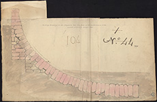
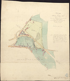
| Description: | Edinburgh: Duddingston & Brunstane. Plan of Estates | |
| Year: | 1820 | |
| Place: | Edinburgh, Duddingston & Brunstane | |
| County: | Edinburgh | |
| Subject: | Reference Material | |
| Inventory: | Drawing | |
| Object: | Flat | |
| Shelfmark: | MS.5848, 35 - Map.Rol.a.9 | |
| Show location on map ? | ||
| Description: | Edinburgh, North Bridge. Sketch | |
| Year: | 1820 | |
| Place: | Edinburgh, North Bridge | |
| County: | Edinburgh | |
| Subject: | Bridge | |
| Inventory: | Series of 2 drawings | |
| Colour: | B&W | |
| Media: | Ink | |
| Object: | Flat | |
| Physical: | Paper | |
| Size: | 350 mm x 520 mm | |
| Shelfmark: | MS.5849, 25 - 26 | |
| Show location on map ? | ||
| Description: | Edinburgh, North Bridge. Transverse section of road-way and parapet | |
| Year: | 1820 | |
| Place: | Edinburgh, North Bridge | |
| County: | Edinburgh | |
| Subject: | Bridge | |
| Inventory: | Drawing | |
| Colour: | Colour | |
| Media: | Hand coloured; Ink | |
| Object: | Flat | |
| Physical: | Paper | |
| Size: | 378 mm x 551 mm | |
| Shelfmark: | MS.5849, 27 | |
| Show location on map ? | ||
| Name: | Stevenson, Robert, 1772-1850 | |
| Description: | Edinburgh, North Bridge. Plans and sections for widening & improving the North Bridge | |
| Year: | 1820 | |
| Place: | Edinburgh, North Bridge | |
| County: | Edinburgh | |
| Subject: | Bridge | |
| Inventory: | Series of 3 drawings | |
| Colour: | Colour | |
| Media: | Hand coloured; Ink | |
| Object: | Flat | |
| Physical: | Paper | |
| Size: | 295 mm x 680 mm | |
| Shelfmark: | MS.5849, 28 | |
| Show location on map ? | ||
 | ||
| Zoom Into Map: | Click on the map to view in greater detail. | |
| Name: | Stevenson, Robert, 1772-1850 | |
| Description: | Edinburgh, North Bridge. Plans and sections for widening & improving the North Bridge | |
| Year: | 1820 | |
| Place: | Edinburgh, North Bridge | |
| County: | Edinburgh | |
| Subject: | Bridge | |
| Inventory: | Series of 3 drawings | |
| Colour: | Colour | |
| Media: | Hand coloured; Ink | |
| Object: | Folded | |
| Physical: | Paper/Linen/Cloth | |
| Size: | 746 mm x 1147 mm | |
| Shelfmark: | MS.5849, 29 | |
 | ||
| Zoom Into Map: | Click on the map to view in greater detail. | |
| Name: | Stevenson, Robert, 1772-1850 | |
| Description: | Edinburgh, North Bridge. Plans and sections for widening & improving the North Bridge | |
| Year: | 1820 | |
| Place: | Edinburgh, North Bridge | |
| County: | Edinburgh | |
| Subject: | Bridge | |
| Inventory: | Series of 3 drawings | |
| Colour: | Colour | |
| Media: | Hand coloured; Ink | |
| Object: | Folded | |
| Physical: | Paper/Linen/Cloth | |
| Size: | 710 mm x 1280 mm | |
| Shelfmark: | MS.5849, 30 | |
 | ||
| Zoom Into Map: | Click on the map to view in greater detail. | |
| Name: | Playfair, William Henry, 1790-1857 | |
| Description: | Edinburgh, London Road. Sections of drains | |
| Year: | 1821 | |
| Place: | Edinburgh, London Road | |
| County: | Edinburgh | |
| Subject: | Road | |
| Inventory: | Series of 6 drawings | |
| Colour: | Colour | |
| Media: | Hand coloured; Ink | |
| Object: | Folded | |
| Physical: | Paper | |
| Size: | 524 mm x 625 mm | |
| Shelfmark: | MS.5849, 2-7 | |
| Show location on map ? | ||
| Name: | Playfair, William Henry, 1790-1857 | |
| Description: | Edinburgh, Royal Terrace. Specification and plans for excavating ground for houses in Royal Terrace & forming road to Leith Walk | |
| Year: | 1821 | |
| Place: | Edinburgh, Royal Terrace | |
| County: | Edinburgh | |
| Subject: | Road | |
| Inventory: | Series of 3 drawings | |
| Colour: | B&W | |
| Media: | Graphite; Ink | |
| Object: | Flat | |
| Physical: | Paper | |
| Size: | 531 mm x 565 mm | |
| Shelfmark: | MS.5849, 70 | |
| Show location on map ? | ||
 | ||
| Zoom Into Map: | Click on the map to view in greater detail. | |
| Name: | Playfair, William Henry, 1790-1857 | |
| Description: | Edinburgh, Royal Terrace. Cellars and sections of houses | |
| Year: | 1821 | |
| Place: | Edinburgh, Royal Terrace | |
| County: | Edinburgh | |
| Subject: | Road | |
| Inventory: | Series of 6 drawings | |
| Colour: | Colour | |
| Media: | Hand coloured; Ink | |
| Object: | Flat | |
| Physical: | Paper | |
| Size: | 145 mm x 177 mm | |
| Shelfmark: | MS.5849, 73 | |
| Show location on map ? | ||
| Description: | Edinburgh, Trinity. Perspective view of suspension pier | |
| Year: | 1821 | |
| Place: | Edinburgh, Trinity | |
| County: | Edinburgh | |
| Subject: | Harbour | |
| Inventory: | Printed by W H Lizars | |
| Colour: | B&W | |
| Media: | Printed | |
| Object: | Flat | |
| Physical: | Paper | |
| Size: | 282 mm x 222 mm | |
| Shelfmark: | MS.5849, 79 | |
| Show location on map ? | ||
 | ||
| Zoom Into Map: | Click on the map to view in greater detail. | |
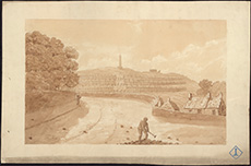
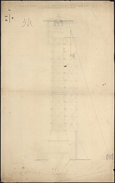
| Description: | Lord Melville's Monument. Sketch showing the situation of Lord Melville's Monument with respect to George Street and the Excise Office, 1821. | |
| Year: | 1821 | |
| Place: | Edinburgh, Melville's Monument | |
| County: | Edinburgh | |
| Subject: | Building/Monument | |
| Colour: | B&W | |
| Media: | None | |
| Object: | Flat | |
| Physical: | Paper | |
| Size: | 315 x 530 mm | |
| Shelfmark: | Acc.10706, 357 | |
| Show location on map ? | ||
 | ||
| Zoom Into Map: | Click on the map to view in greater detail. | |
| Name: | Stevenson, Robert, 1772-1850 | |
| Description: | Lord Melville's Monument. Section of the foundation-pit and underground work of the Melville Monument, Robert Stevenson, 1821. | |
| Year: | 1821 | |
| Place: | Edinburgh, Melville's Monument | |
| County: | Edinburgh | |
| Subject: | Building/Monument | |
| Colour: | Colour | |
| Media: | Linen/Cloth | |
| Object: | Flat | |
| Physical: | Paper | |
| Size: | 350 x 465 mm | |
| Shelfmark: | Acc.10706, 358 | |
| Show location on map ? | ||
 | ||
| Zoom Into Map: | Click on the map to view in greater detail. | |
| Name: | Playfair, William Henry, 1790-1857 | |
| Description: | Edinburgh, Royal Terrace. Specification and plans for excavating ground for houses in Royal Terrace & forming road to Leith Walk | |
| Year: | 1821 | |
| Place: | Edinburgh, Royal Terrace | |
| County: | Edinburgh | |
| Subject: | Road | |
| Inventory: | Series of 3 drawings | |
| Colour: | Colour | |
| Media: | Hand coloured; Ink | |
| Object: | Flat | |
| Physical: | Paper | |
| Size: | 490 mm x 600 mm | |
| Shelfmark: | MS.5849, 71 | |
 | ||
| Zoom Into Map: | Click on the map to view in greater detail. | |
| Name: | Playfair, William Henry, 1790-1857 | |
| Description: | Edinburgh, Royal Terrace. Specification and plans for excavating ground for houses in Royal Terrace & forming road to Leith Walk | |
| Year: | 1821 | |
| Place: | Edinburgh, Royal Terrace | |
| County: | Edinburgh | |
| Subject: | Road | |
| Inventory: | Series of 3 drawings | |
| Colour: | Colour | |
| Media: | Hand coloured; Ink | |
| Object: | Flat | |
| Physical: | Paper | |
| Size: | 552 mm x 674 mm | |
| Shelfmark: | MS.5849, 72 | |
| Name: | Playfair, William Henry, 1790-1857 | |
| Description: | Edinburgh, Royal Terrace. Cellars and sections of houses | |
| Year: | 1821 | |
| Place: | Edinburgh, Royal Terrace | |
| County: | Edinburgh | |
| Subject: | Building/Monument | |
| Inventory: | Series of 6 drawings | |
| Colour: | Colour | |
| Media: | Hand coloured; Ink | |
| Object: | Flat | |
| Physical: | Paper | |
| Size: | 170 mm x 528 mm | |
| Shelfmark: | MS.5849, 74 | |
 | ||
| Zoom Into Map: | Click on the map to view in greater detail. | |
| Name: | Playfair, William Henry, 1790-1857 | |
| Description: | Edinburgh, Royal Terrace. Cellars and sections of houses | |
| Year: | 1821 | |
| Place: | Edinburgh, Royal Terrace | |
| County: | Edinburgh | |
| Subject: | Building/Monument | |
| Inventory: | Series of 6 drawings | |
| Colour: | Colour | |
| Media: | Hand coloured; Ink | |
| Object: | Flat | |
| Physical: | Paper | |
| Size: | 250 mm x 446 mm | |
| Shelfmark: | MS.5849, 75 | |
| Name: | Playfair, William Henry, 1790-1857 | |
| Description: | Edinburgh, Royal Terrace. Cellars and sections of houses | |
| Year: | 1821 | |
| Place: | Edinburgh, Royal Terrace | |
| County: | Edinburgh | |
| Subject: | Building/Monument | |
| Inventory: | Series of 6 drawings | |
| Colour: | Colour | |
| Media: | Hand coloured; Ink | |
| Object: | Flat | |
| Physical: | Paper | |
| Size: | 322 mm x 525 mm | |
| Shelfmark: | MS.5849, 76 | |
| Name: | Playfair, William Henry, 1790-1857 | |
| Description: | Edinburgh, Royal Terrace. Cellars and sections of houses | |
| Year: | 1821 | |
| Place: | Edinburgh, Royal Terrace | |
| County: | Edinburgh | |
| Subject: | Building/Monument | |
| Inventory: | Series of 6 drawings | |
| Colour: | Colour | |
| Media: | Hand coloured; Ink | |
| Object: | Flat | |
| Physical: | Paper | |
| Size: | 275 mm x 504 mm | |
| Shelfmark: | MS.5849, 77 | |
| Name: | Playfair, William Henry, 1790-1857 | |
| Description: | Edinburgh, Royal Terrace. Cellars and sections of houses | |
| Year: | 1821 | |
| Place: | Edinburgh, Royal Terrace | |
| County: | Edinburgh | |
| Subject: | Building/Monument | |
| Inventory: | Series of 6 drawings | |
| Colour: | Colour | |
| Media: | Hand coloured; Ink | |
| Object: | Flat | |
| Physical: | Paper | |
| Size: | 242 mm x 537 mm | |
| Shelfmark: | MS.5849, 78 | |
 | ||
| Zoom Into Map: | Click on the map to view in greater detail. | |
| Name: | Stevenson, Robert, 1772-1850 | |
| Description: | Edinburgh, Trinity. Proposes sea wallon north side of lands of Trinity Lodge | |
| Year: | 1822 | |
| Place: | Edinburgh, Trinity | |
| County: | Edinburgh | |
| Subject: | Harbour | |
| Inventory: | Series of 2 drawings | |
| Colour: | B&W | |
| Media: | Graphite | |
| Object: | Flat | |
| Physical: | Paper | |
| Size: | 680 mm x 987 mm | |
| Shelfmark: | MS.5849, 81 | |
 | ||
| Zoom Into Map: | Click on the map to view in greater detail. | |
| Name: | Stevenson, Robert, 1772-1850 | |
| Description: | Lord Melville's Monument. Elevation of Lord Melville's Monument showing the scaffolding employed in it's erection. R Stevenson, 1822. | |
| Year: | 1822 | |
| Place: | Edinburgh, Melville's Monument | |
| County: | Edinburgh | |
| Subject: | Building/Monument | |
| Colour: | B&W | |
| Object: | Flat | |
| Physical: | Paper | |
| Size: | 990 x 615 mm | |
| Shelfmark: | Acc.10706, 356 | |
| Show location on map ? | ||
 | ||
| Zoom Into Map: | Click on the map to view in greater detail. | |
| Name: | Stevenson, Robert, 1772-1850 | |
| Description: | Drains. Sketch plan of Broughton Road and the neighbouring streets showing the direction of the drains. (referred to in a report by Robert Stevenson), 1822. | |
| Year: | 1822 | |
| Place: | Edinburgh, Broughton Road | |
| County: | Edinburgh | |
| Subject: | Water Supply Works | |
| Colour: | Colour | |
| Media: | None | |
| Object: | Flat | |
| Physical: | Paper | |
| Size: | 621 x 500 mm | |
| Shelfmark: | Acc.10706, 287 | |
| Show location on map ? | ||
| Name: | Stevenson, Robert, 1772-1850 | |
| Description: | Edinburgh, Trinity. Proposes sea wallon north side of lands of Trinity Lodge | |
| Year: | 1822 | |
| Place: | Edinburgh, Trinity | |
| County: | Edinburgh | |
| Subject: | Harbour | |
| Inventory: | Series of 2 drawings | |
| Colour: | Colour | |
| Media: | Hand coloured; Ink | |
| Object: | Flat | |
| Physical: | Paper | |
| Size: | 655 mm x 1005 mm | |
| Shelfmark: | MS.5849, 80 | |
| Show location on map ? | ||
 | ||
| Zoom Into Map: | Click on the map to view in greater detail. | |
| Name: | Stevenson, Robert, 1772-1850 | |
| Description: | Edinburgh. Plan and section of aqueduct & reservoir | |
| Year: | 1824 | |
| Place: | Edinburgh | |
| County: | Edinburgh | |
| Subject: | Water Supply Works | |
| Inventory: | Drawing | |
| Colour: | Colour | |
| Media: | Hand coloured; Ink | |
| Object: | Flat | |
| Physical: | Paper/Linen/Cloth | |
| Size: | 680 mm x 1620 mm | |
| Shelfmark: | MS.5849, 98 | |
| Show location on map ? | ||
 | ||
| Zoom Into Map: | Click on the map to view in greater detail. | |
| Name: | Crawford, David | |
| Description: | . Sketch map of the City of Edinburgh and Leith with the Estate of Prestonfield and lands adjacent, David Crawford, Surveyor, 1824. | |
| Year: | 1824 | |
| Place: | Edinburgh | |
| County: | Edinburgh | |
| Subject: | Reference Material | |
| Colour: | Colour | |
| Media: | Linen/Cloth | |
| Object: | Flat | |
| Physical: | Paper | |
| Size: | 1010 x 770 mm | |
| Shelfmark: | Acc.10706, 380 | |
| Show location on map ? | ||
 | ||
| Zoom Into Map: | Click on the map to view in greater detail. | |
| Name: | Stevenson, Robert, 1772-1850 | |
| Description: | Roads and Bridges - Edinburgh. Sketch of a new proposed access from the Cross to the Grass Market. Robert Stevenson, 1824. | |
| Year: | 1824 | |
| Place: | Edinburgh, Grassmarket | |
| County: | Edinburgh | |
| Subject: | Road | |
| Colour: | Colour | |
| Media: | Linen/Cloth | |
| Object: | Flat | |
| Physical: | Paper | |
| Size: | 525 x 1300 mm | |
| Shelfmark: | Acc.10706, 466 | |
| Show location on map ? | ||
 | ||
| Zoom Into Map: | Click on the map to view in greater detail. | |
| Name: | Crawford, David | |
| Description: | Edinburgh, Prestonfield. Park & Grounds, belonging to Sir Rob.K.Dick | |
| Year: | 1825 | |
| Place: | Edinburgh, Prestonfield | |
| County: | Edinburgh | |
| Subject: | Reference Material | |
| Inventory: | Print by Kirkwood, Edinburgh | |
| Colour: | Colour | |
| Media: | Hand coloured; Printed | |
| Object: | Flat | |
| Physical: | Paper | |
| Size: | 370 mm x 240 mm | |
| Shelfmark: | MS.5849, 46 | |
| Show location on map ? | ||
| Name: | Steedman, John | |
| Description: | Edinburgh: Black Springs. Survey of district | |
| Year: | 1825 | |
| Place: | Edinburgh, Black Springs | |
| County: | Edinburgh | |
| Subject: | Reference Material | |
| Inventory: | Drawing | |
| Colour: | Colour | |
| Media: | Hand coloured; Ink | |
| Object: | Flat | |
| Physical: | Paper/Linen/Cloth | |
| Size: | 670 mm x 994 mm | |
| Shelfmark: | MS.5848, 6 | |
| Show location on map ? | ||
 | ||
| Zoom Into Map: | Click on the map to view in greater detail. | |
| Name: | Steedman, John | |
| Description: | Edinburgh, Leith, Water of. Plan at Greenland Mills | |
| Year: | 1827 | |
| Place: | Edinburgh, Leith, Water of | |
| County: | Edinburgh | |
| Subject: | Reference Material | |
| Inventory: | Drawing | |
| Colour: | Colour | |
| Media: | Graphite; Hand coloured; Ink | |
| Object: | Flat | |
| Physical: | Paper | |
| Size: | 540 mm x 660 mm | |
| Shelfmark: | MS.5848, 97 | |
| Show location on map ? | ||
| Description: | . Sections of the Bank upon the northern side of Moray & Ainslie Place, 1827. | |
| Year: | 1827 | |
| Place: | Edinburgh | |
| County: | Edinburgh | |
| Subject: | Building/Monument | |
| Colour: | Colour | |
| Media: | None | |
| Object: | Flat | |
| Physical: | Paper | |
| Size: | 515 x 620 mm | |
| Shelfmark: | Acc.10706, 384 | |
| Show location on map ? | ||
 | ||
| Zoom Into Map: | Click on the map to view in greater detail. | |
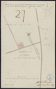
| Name: | Stevenson, Robert, 1772-1850 | |
| Description: | Edinburgh, Prestonfield. Survey in reference to tunnel works through the lands of Sir R.K.Dick | |
| Year: | 1828 | |
| Place: | Edinburgh, Prestonfield | |
| County: | Edinburgh | |
| Subject: | Reference Material | |
| Inventory: | Drawing | |
| Colour: | Colour | |
| Media: | Hand coloured; Ink | |
| Object: | Flat | |
| Physical: | Paper | |
| Size: | 323 mm x 204 mm | |
| Shelfmark: | MS.5849, 47 | |
| Show location on map ? | ||
 | ||
| Zoom Into Map: | Click on the map to view in greater detail. | |
| Description: | Edinburgh: Dean Bridge. Elevation and cross sections of West Side | |
| Year: | 1828 | |
| Place: | Edinburgh, Dean Bridge | |
| County: | Edinburgh | |
| Subject: | Bridge | |
| Inventory: | Series of 4 drawings | |
| Colour: | Colour | |
| Media: | Graphite; Hand coloured; Ink | |
| Object: | Folded | |
| Physical: | Transparent paper/Paper | |
| Size: | 985 mm x 680 mm | |
| Shelfmark: | MS.5848, 30 | |
| Show location on map ? | ||
| Description: | Edinburgh: Dean Bridge. Elevation and cross sections of West Side | |
| Year: | 1828 | |
| Place: | Edinburgh, Dean Bridge | |
| County: | Edinburgh | |
| Subject: | Bridge | |
| Inventory: | Series of 4 drawings | |
| Colour: | B&W | |
| Media: | Graphite | |
| Object: | Flat | |
| Physical: | Paper | |
| Size: | 550 mm x 380 mm | |
| Shelfmark: | MS.5848, 31 | |
| Show location on map ? | ||
 | ||
| Zoom Into Map: | Click on the map to view in greater detail. | |
| Description: | Edinburgh: Dean Bridge. Elevation and cross sections of West Side | |
| Year: | 1828 | |
| Place: | Edinburgh, Dean Bridge | |
| County: | Edinburgh | |
| Subject: | Bridge | |
| Inventory: | Series of 4 drawings | |
| Colour: | B&W | |
| Media: | Ink | |
| Object: | Flat | |
| Physical: | Paper | |
| Size: | 375 mm x 530 mm | |
| Shelfmark: | MS.5848, 32 | |
| Show location on map ? | ||
 | ||
| Zoom Into Map: | Click on the map to view in greater detail. | |
| Description: | Edinburgh: Dean Bridge. Elevation and cross sections of West Side | |
| Year: | 1828 | |
| Place: | Edinburgh, Dean Bridge | |
| County: | Edinburgh | |
| Subject: | Bridge | |
| Inventory: | Series of 4 drawings | |
| Colour: | Colour | |
| Media: | Hand coloured; Ink | |
| Object: | Flat | |
| Physical: | Paper | |
| Size: | 332 mm x 482 mm | |
| Shelfmark: | MS.5848, 33 | |
| Show location on map ? | ||
 | ||
| Zoom Into Map: | Click on the map to view in greater detail. | |
| Description: | . Plan and section of the retaining arches for the grounds behind Mr Lorimer's house in Ainslie Place, 1829. | |
| Year: | 1829 | |
| Place: | Edinburgh | |
| County: | Edinburgh | |
| Subject: | Building/Monument | |
| Colour: | Colour | |
| Media: | None | |
| Object: | Flat | |
| Physical: | Paper | |
| Size: | 530 x 645 mm | |
| Shelfmark: | Acc.10706, 383 | |
| Show location on map ? | ||
 | ||
| Zoom Into Map: | Click on the map to view in greater detail. | |
| Description: | . Sketch map of the streets adjacent to the top of Leith Walk showing projected new streets, on paper watermarked 1830. | |
| Year: | 1830 | |
| Place: | Edinburgh | |
| County: | Edinburgh | |
| Subject: | Road | |
| Colour: | Colour | |
| Media: | None | |
| Object: | Flat | |
| Physical: | Paper | |
| Size: | 405 x 585 mm | |
| Shelfmark: | Acc.10706, 381 | |
| Show location on map ? | ||
 | ||
| Zoom Into Map: | Click on the map to view in greater detail. | |
| Name: | Stevenson, Robert, 1772-1850 | |
| Description: | Edinburgh: Howard Place. New road to Warriston | |
| Year: | 1831 | |
| Place: | Edinburgh, Howard Place | |
| County: | Edinburgh | |
| Subject: | Road | |
| Inventory: | Drawing | |
| Colour: | Colour | |
| Media: | Hand coloured; Ink | |
| Object: | Flat | |
| Physical: | Paper | |
| Size: | 664 mm x 990 mm | |
| Shelfmark: | MS.5848, 62 | |
| Show location on map ? | ||
| Name: | Stevenson, Robert, 1772-1850 | |
| Description: | Edinburgh: Hillside. Lands showing City Boundary and Parish of South Leith | |
| Year: | 1833 | |
| Place: | Edinburgh, Hillside | |
| County: | Edinburgh | |
| Subject: | Reference Material | |
| Inventory: | Drawing | |
| Colour: | Colour | |
| Media: | Hand coloured; Ink | |
| Object: | Flat | |
| Physical: | Paper | |
| Size: | 548 mm x 752 mm | |
| Shelfmark: | MS.5848, 60 | |
| Show location on map ? | ||
| Name: | Stevenson, Robert, 1772-1850 | |
| Description: | Edinburgh: Hillside. James Grant's feu, showing boundary of South Leith | |
| Year: | 1833 | |
| Place: | Edinburgh, Hillside | |
| County: | Edinburgh | |
| Subject: | Reference Material | |
| Inventory: | Drawing | |
| Colour: | Colour | |
| Media: | Graphite; Hand coloured; Ink | |
| Object: | Flat | |
| Physical: | Paper | |
| Size: | 496 mm x 728 mm | |
| Shelfmark: | MS.5848, 61 | |
| Show location on map ? | ||
 | ||
| Zoom Into Map: | Click on the map to view in greater detail. | |
| Name: | Stevenson, Robert, 1772-1850 | |
| Description: | Edinburgh: Canongate. Survey of Tan Work of Messrs. Wm. & Oliver Gilmore | |
| Year: | 1834 | |
| Place: | Edinburgh, Canongate | |
| County: | Edinburgh | |
| Subject: | Building/Monument | |
| Inventory: | Drawing | |
| Colour: | Colour | |
| Media: | Graphite; Hand coloured; Ink | |
| Object: | Flat | |
| Physical: | Paper | |
| Size: | 547 mm x 753 mm | |
| Shelfmark: | MS.5848, 16 | |
| Show location on map ? | ||
| Description: | Edinburgh, North Bridge. Sketch showing method of widening | |
| Year: | 1835 | |
| Place: | Edinburgh, North Bridge | |
| County: | Edinburgh | |
| Subject: | Bridge | |
| Inventory: | Drawing | |
| Colour: | Colour | |
| Media: | Hand coloured; Ink | |
| Object: | Flat | |
| Physical: | Paper | |
| Size: | 270 mm x 610 mm | |
| Shelfmark: | MS.5849, 31 | |
| Show location on map ? | ||
 | ||
| Zoom Into Map: | Click on the map to view in greater detail. | |
| Name: | Kemp, William | |
| Description: | Edinburgh, North Bridge. Design | |
| Year: | 1835 | |
| Place: | Edinburgh, North Bridge | |
| County: | Edinburgh | |
| Subject: | Bridge | |
| Inventory: | Series of 2 drawings | |
| Colour: | Colour | |
| Media: | Hand coloured; Ink | |
| Object: | Flat | |
| Physical: | Paper | |
| Size: | 373 mm x 645 mm | |
| Shelfmark: | MS.5849, 32-33 | |
| Show location on map ? | ||
 | ||
| Zoom Into Map: | Click on the map to view in greater detail. | |
| Description: | Edinburgh: Canonmills. Plan of Canonmills Loch | |
| Year: | 1836 | |
| Place: | Edinburgh, Canonmills | |
| County: | Edinburgh | |
| Subject: | Reference Material | |
| Inventory: | Drawing | |
| Colour: | Colour | |
| Media: | Graphite; Hand coloured; Ink | |
| Object: | Flat | |
| Physical: | Paper | |
| Size: | 478 mm x 593 mm | |
| Shelfmark: | MS.5848, 21 | |
| Show location on map ? | ||
 | ||
| Zoom Into Map: | Click on the map to view in greater detail. | |
| Name: | Stevenson, Robert, 1772-1850 | |
| Description: | Springfield. Plan of road and sections | |
| Year: | 1836 | |
| Place: | Edinburgh, Springfield | |
| County: | Edinburgh | |
| Subject: | Road | |
| Inventory: | Drawing | |
| Colour: | Colour | |
| Media: | None | |
| Object: | Flat | |
| Physical: | Card | |
| Size: | 775 x 1900 mm | |
| Shelfmark: | MS.5862, 102 | |
| Show location on map ? | ||
| Description: | . Map of the City of Edinburgh drawn and engraved for Gray's Annual Directory by A K Johnston, 1837. | |
| Year: | 1837 | |
| Place: | Edinburgh | |
| County: | Edinburgh | |
| Subject: | Reference Material | |
| Colour: | Colour | |
| Media: | None | |
| Object: | Flat | |
| Physical: | Paper | |
| Size: | 555 x 440 mm | |
| Shelfmark: | Acc.10706, 379 | |
| Show location on map ? | ||
 | ||
| Zoom Into Map: | Click on the map to view in greater detail. | |
| Name: | Buchanan, George, 1790?-1852 | |
| Description: | . Plan of the Bank behind Moray Place and Ainslie Place ... From a survey by George Buchanan, Civil Engineer, 1837. | |
| Year: | 1837 | |
| Place: | Edinburgh | |
| County: | Edinburgh | |
| Subject: | Building/Monument | |
| Colour: | Colour | |
| Media: | None | |
| Object: | Folded | |
| Physical: | Paper | |
| Size: | 820 x 1250 mm | |
| Shelfmark: | Acc.10706, 385 | |
| Show location on map ? | ||
| Name: | Buchanan, George, 1790?-1852 | |
| Description: | . Plan of the Bank behind Moray Place and Ainslie Place ...From a survey by George Buchanan, Civil Engineer, 1837. | |
| Year: | 1837 | |
| Place: | Edinburgh | |
| County: | Edinburgh | |
| Subject: | Reference Material | |
| Colour: | Colour | |
| Media: | None | |
| Object: | Flat | |
| Physical: | Card | |
| Size: | 670 x 1000 mm | |
| Shelfmark: | Acc.10706, 386 | |
| Show location on map ? | ||
| Name: | Buchanan, George, 1790?-1852 | |
| Description: | . Cross sections of the bank behind Moray Place from Water of Leith to Building. 1837. George Buchanan. | |
| Year: | 1837 | |
| Place: | Edinburgh | |
| County: | Edinburgh | |
| Subject: | Building/Monument | |
| Colour: | Colour | |
| Media: | None | |
| Object: | Flat | |
| Physical: | Paper | |
| Size: | 920 x 650 mm | |
| Shelfmark: | Acc.10706, 387 | |
| Show location on map ? | ||
 | ||
| Zoom Into Map: | Click on the map to view in greater detail. | |
| Name: | Buchanan, George, 1790?-1852 | |
| Description: | . Cross sections of the bank behind Moray Place from Water of Leith to Building. 1837. George Buchanan. | |
| Year: | 1837 | |
| Place: | Edinburgh | |
| County: | Edinburgh | |
| Subject: | Building/Monument | |
| Colour: | Colour | |
| Media: | None | |
| Object: | Flat | |
| Physical: | Paper | |
| Size: | 880 x 655 mm | |
| Shelfmark: | Acc.10706, 388 | |
| Show location on map ? | ||
 | ||
| Zoom Into Map: | Click on the map to view in greater detail. | |
| Name: | Buchanan, George, 1790?-1852 | |
| Description: | . Cross sections of the bank behind Moray Place from Water of Leith to Building. 1837. George Buchanan. | |
| Year: | 1837 | |
| Place: | Edinburgh | |
| County: | Edinburgh | |
| Subject: | Building/Monument | |
| Colour: | Colour | |
| Media: | None | |
| Object: | Flat | |
| Physical: | Paper | |
| Size: | 990 x 665 mm | |
| Shelfmark: | Acc.10706, 389 | |
| Show location on map ? | ||
| Name: | Buchanan, George, 1790?-1852 | |
| Description: | . Cross sections of the bank behind Moray Place from Water of Leith to Building. 1837. George Buchanan. | |
| Year: | 1837 | |
| Place: | Edinburgh | |
| County: | Edinburgh | |
| Subject: | Building/Monument | |
| Colour: | Colour | |
| Media: | None | |
| Object: | Flat | |
| Physical: | Paper | |
| Size: | 995 x 665 mm | |
| Shelfmark: | Acc.10706, 390 | |
| Show location on map ? | ||
| Description: | North Bridge. Edinburgh. ?North Bridge. Signed: 'Thos. Brown, City Supert.' 9th May 1837 | |
| Year: | 1837 | |
| Place: | Edinburgh, North Bridge | |
| County: | Edinburgh | |
| Subject: | Bridge | |
| Shelfmark: | MS.5896, 4 | |
 | ||
| Zoom Into Map: | Click on the map to view in greater detail. | |
| Name: | Cousin, David | |
| Description: | . Plan showing part of the Parliament Square, with former site of President's Stairs, with written report. David Cousin, Architect, 1838. | |
| Year: | 1838 | |
| Place: | Edinburgh | |
| County: | Edinburgh | |
| Subject: | Building/Monument | |
| Colour: | B&W | |
| Media: | None | |
| Object: | Flat | |
| Physical: | Paper | |
| Size: | 445 x 245 mm | |
| Shelfmark: | Acc.10706, 393 | |
| Show location on map ? | ||
 | ||
| Zoom Into Map: | Click on the map to view in greater detail. | |
| Name: | M.S. | |
| Description: | Edinburgh: Easter Road. Survey of Baron Norton's feu | |
| Year: | 1838 | |
| Place: | Edinburgh, Easter Road | |
| County: | Edinburgh | |
| Subject: | Reference Material | |
| Inventory: | Drawing | |
| Colour: | Colour | |
| Media: | Hand coloured; Ink | |
| Object: | Flat | |
| Physical: | Paper | |
| Size: | 620 mm x 530 mm | |
| Shelfmark: | MS.5848, 41 | |
| Show location on map ? | ||
 | ||
| Zoom Into Map: | Click on the map to view in greater detail. | |
| Name: | Stevenson, Robert, 1772-1850 | |
| Description: | Edinburgh, London Road. Cross Sections | |
| Year: | 1838 | |
| Place: | Edinburgh, London Road | |
| County: | Edinburgh | |
| Subject: | Road | |
| Inventory: | Drawing | |
| Colour: | Colour | |
| Media: | Hand coloured; Ink | |
| Object: | Folded | |
| Physical: | Paper | |
| Size: | 320 mm x 1680 mm | |
| Shelfmark: | MS.5849, 8 | |
| Show location on map ? | ||
 | ||
| Zoom Into Map: | Click on the map to view in greater detail. | |
| Name: | Stevenson, Robert, 1772-1850 | |
| Description: | Edinburgh, Leith, Water of. Position of weir proposes to be constructed near St. Bernards Well | |
| Year: | 1839 | |
| Place: | Edinburgh, Leith, Water of | |
| County: | Edinburgh | |
| Subject: | River | |
| Inventory: | Series of 3 drawings | |
| Colour: | Colour | |
| Media: | Graphite; Hand coloured; Ink | |
| Object: | Folded | |
| Physical: | Paper | |
| Size: | 680 mm x 920 mm | |
| Shelfmark: | MS.5848, 101-103 | |
| Show location on map ? | ||
| Name: | Stevenson, David, 1815-1886 | |
| Description: | Edinburgh: Canonmills. Plan of loch and adjoining lands | |
| Year: | 1839 | |
| Place: | Edinburgh, Canonmills | |
| County: | Edinburgh | |
| Subject: | Reference Material | |
| Inventory: | Tracing | |
| Colour: | Colour | |
| Media: | Hand coloured; Ink | |
| Object: | Flat | |
| Physical: | Transparent paper | |
| Size: | 520 mm x 420 mm | |
| Shelfmark: | MS.5848, 22 | |
| Show location on map ? | ||
| Description: | Edinburgh: Calton Hill. Plan and section of proposed stair of Greenside Wall | |
| Year: | 1845 | |
| Place: | Edinburgh, Calton Hill | |
| County: | Edinburgh | |
| Subject: | Road | |
| Inventory: | Drawing | |
| Colour: | Colour | |
| Media: | Hand coloured; Ink | |
| Object: | Flat | |
| Physical: | Paper | |
| Size: | 450 mm x 490 mm | |
| Shelfmark: | MS.5848, 11 | |
| Show location on map ? | ||
 | ||
| Zoom Into Map: | Click on the map to view in greater detail. | |
| Name: | Stevenson, Robert, 1772-1850 | |
| Description: | Edinburgh, North Bridge. Improvements: sketches and sections | |
| Year: | 1845 | |
| Place: | Edinburgh, North Bridge | |
| County: | Edinburgh | |
| Subject: | Bridge | |
| Inventory: | Series of 6 drawings | |
| Colour: | Colour | |
| Media: | Graphite; Hand coloured; Ink | |
| Object: | Flat | |
| Physical: | Paper | |
| Size: | 680 mm x 1000 mm | |
| Shelfmark: | MS.5849, 34-39 | |
| Show location on map ? | ||
| Name: | Racine | |
| Description: | Edinburgh. Map of shire of Edinburgh | |
| Year: | 1847 | |
| Place: | Edinburgh | |
| County: | Edinburgh | |
| Subject: | Reference Material | |
| Inventory: | Section of Ordnance Survey map | |
| Colour: | B&W | |
| Media: | Printed | |
| Object: | Flat | |
| Physical: | Paper/Linen/Cloth | |
| Size: | 530 mm x 675 mm | |
| Shelfmark: | MS.5849, 103 | |
| Show location on map ? | ||
| Name: | Hay, William Hardie | |
| Description: | Edinburgh: Comely Gardens. Survey of ground belonging to Robert Mason | |
| Year: | 1848 | |
| Place: | Edinburgh, Comely Gardens | |
| County: | Edinburgh | |
| Subject: | Reference Material | |
| Inventory: | Drawing | |
| Colour: | Colour | |
| Media: | Hand coloured; Printed | |
| Object: | Flat | |
| Physical: | Paper | |
| Size: | 590 mm x 715 mm | |
| Shelfmark: | MS.5848, 26 | |
| Show location on map ? | ||
| Name: | Playfair, William Henry, 1790-1857 | |
| Description: | Edinburgh, Mound. Exhibition Rooms-Royal Academy & Nat Gallery | |
| Year: | 1850 | |
| Place: | Edinburgh, Mound | |
| County: | Edinburgh | |
| Subject: | Building/Monument | |
| Inventory: | Drawing | |
| Colour: | Colour | |
| Media: | Hand coloured; Ink | |
| Object: | Flat | |
| Physical: | Paper | |
| Size: | 507 mm x 720 mm | |
| Shelfmark: | MS.5849, 10 | |
| Show location on map ? | ||
 | ||
| Zoom Into Map: | Click on the map to view in greater detail. | |
| Name: | Playfair, William Henry, 1790-1857 | |
| Description: | Edinburgh, Mound. Exhibition Rooms-Royal Academy & Nat Gallery | |
| Year: | 1850 | |
| Place: | Edinburgh, Mound | |
| County: | Edinburgh | |
| Subject: | Building/Monument | |
| Inventory: | Series of 2 drawings | |
| Colour: | Colour | |
| Media: | Graphite; Hand coloured; Ink | |
| Object: | Flat | |
| Physical: | Paper | |
| Size: | 520 mm x 730 mm | |
| Shelfmark: | MS.5849, 11 - 12 | |
| Show location on map ? | ||
 | ||
| Zoom Into Map: | Click on the map to view in greater detail. | |
| Name: | Playfair, William Henry, 1790-1857 | |
| Description: | Edinburgh, Mound. Exhibition Rooms-Royal Academy & Nat Gallery: plan of foundations | |
| Year: | 1850 | |
| Place: | Edinburgh, Mound | |
| County: | Edinburgh | |
| Subject: | Building/Monument | |
| Inventory: | Drawing | |
| Colour: | Colour | |
| Media: | Hand coloured; Ink | |
| Object: | Flat | |
| Physical: | Paper | |
| Size: | 500 mm x 725 mm | |
| Shelfmark: | MS.5849, 13 | |
| Show location on map ? | ||
 | ||
| Zoom Into Map: | Click on the map to view in greater detail. | |
| Name: | Playfair, William Henry, 1790-1857 | |
| Description: | Edinburgh, Mound. Nat. Galleries: Iron Work to strengthen masonary above railway tunnel | |
| Year: | 1852 | |
| Place: | Edinburgh, Mound | |
| County: | Edinburgh | |
| Subject: | Building/Monument | |
| Inventory: | Drawing | |
| Colour: | Colour | |
| Media: | Hand coloured; Ink | |
| Object: | Flat | |
| Physical: | Paper | |
| Size: | 626 mm x 958 mm | |
| Shelfmark: | MS.5849, 14 | |
| Show location on map ? | ||
| Description: | Edinburgh, Leith, Water of. Section of mill leads at St Bernard's Well and Canonmills and formulae for the calculation of water velocity in ink and pencil on paper watermarked 1852. | |
| Year: | 1852 | |
| Place: | Edinburgh, Leith, Water of | |
| County: | Edinburgh | |
| Subject: | Building/Monument | |
| Colour: | Colour | |
| Media: | None | |
| Object: | Flat | |
| Physical: | Paper | |
| Size: | 547 x 757 mm | |
| Shelfmark: | Acc.10706, 286 | |
| Show location on map ? | ||
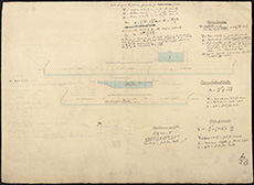 | ||
| Zoom Into Map: | Click on the map to view in greater detail. | |
| Description: | Lights - Apparatus etc. Trial of Holophotal condenser at Portobello, 1856. | |
| Year: | 1856 | |
| Place: | Edinburgh, Portobello | |
| County: | Edinburgh | |
| Subject: | Machinery | |
| Shelfmark: | Acc.10706, 576 | |
| Show location on map ? | ||
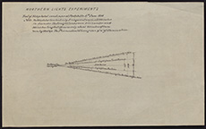 | ||
| Zoom Into Map: | Click on the map to view in greater detail. | |
| Name: | Racine | |
| Description: | Edinburgh. Map of shire of Edinburgh | |
| Year: | 1857 | |
| Place: | Edinburgh | |
| County: | Edinburgh | |
| Subject: | Reference Material | |
| Inventory: | Section of Ordnance Survey map | |
| Colour: | B&W | |
| Media: | Printed | |
| Object: | Flat | |
| Physical: | Paper | |
| Size: | 301 mm x 690 mm | |
| Shelfmark: | MS.5849, 102 | |
| Show location on map ? | ||
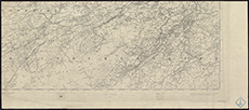 | ||
| Zoom Into Map: | Click on the map to view in greater detail. | |
| Name: | Leslie, James, 1801-1889 | |
| Description: | Edinburgh: Dalry. Caledonian Distillery and Irrigated Meadows | |
| Year: | 1858 | |
| Place: | Edinburgh, Dalry | |
| County: | Edinburgh | |
| Subject: | Building/Monument | |
| Inventory: | Engraving | |
| Colour: | Colour | |
| Media: | Hand coloured; Printed | |
| Object: | Flat | |
| Physical: | Paper | |
| Size: | 516 mm x 726 mm | |
| Shelfmark: | MS.5848, 29 | |
| Show location on map ? | ||
| Description: | Experiments in Queen's Park. Light experiment using prisms and a beehive, 1859. | |
| Year: | 1859 | |
| Place: | Edinburgh, Holyrood Park | |
| County: | Edinburgh | |
| Subject: | Machinery | |
| Colour: | Colour | |
| Media: | None | |
| Object: | Flat | |
| Physical: | Paper | |
| Size: | 420 x 555 mm | |
| Shelfmark: | Acc.10706, 624 | |
| Show location on map ? | ||
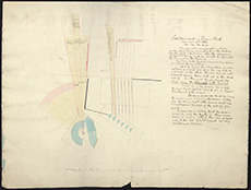 | ||
| Zoom Into Map: | Click on the map to view in greater detail. | |
| Description: | Experiments in Queen's Park. Photometrical experiment on Salisbury Crags, 1860. | |
| Year: | 1860 | |
| Place: | Edinburgh, Holyrood Park | |
| County: | Edinburgh | |
| Subject: | Machinery | |
| Colour: | Colour | |
| Media: | None | |
| Object: | Flat | |
| Physical: | Paper | |
| Size: | 560 x 770 mm | |
| Shelfmark: | Acc.10706, 626 | |
| Show location on map ? | ||
| Description: | Experiments in Queen's Park. Diagrams showing the results of observations made at Arthur's Seat on the Northern Lighthouse Flame, 1861. | |
| Year: | 1861 | |
| Place: | Edinburgh, Holyrood Park | |
| County: | Edinburgh | |
| Subject: | Machinery | |
| Colour: | Colour | |
| Media: | Linen/Cloth | |
| Object: | Flat | |
| Physical: | Transparent paper | |
| Size: | 300 x 890 mm | |
| Shelfmark: | Acc.10706, 625 | |
| Show location on map ? | ||
 | ||
| Zoom Into Map: | Click on the map to view in greater detail. | |
| Name: | Leslie, James, 1801-1889 ; Stevenson, David, 1815-1886 | |
| Description: | Edinburgh: High Street. Plan of houses nos. 99-103 | |
| Year: | 1861 | |
| Place: | Edinburgh, Hill Street | |
| County: | Edinburgh | |
| Subject: | Building/Monument | |
| Inventory: | Drawing | |
| Colour: | Colour | |
| Media: | Graphite; Hand coloured; Ink | |
| Object: | Flat | |
| Physical: | Paper | |
| Size: | 686 mm x 1011 mm | |
| Shelfmark: | MS.5848, 59 | |
| Show location on map ? | ||
| Description: | Edinburgh: Calton Hill. Plan and section of rocks at Steele and Coulston's Brewery | |
| Year: | 1867 | |
| Place: | Edinburgh, Calton Hill | |
| County: | Edinburgh | |
| Subject: | Building/Monument | |
| Inventory: | Drawing | |
| Colour: | Colour | |
| Media: | Hand coloured; Ink | |
| Object: | Flat | |
| Physical: | Paper | |
| Size: | 560 mm x 773 mm | |
| Shelfmark: | MS.5848, 12 | |
| Show location on map ? | ||
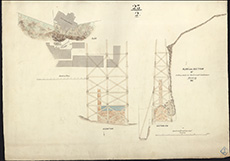 | ||
| Zoom Into Map: | Click on the map to view in greater detail. | |
| Description: | Edinburgh, North Bridge. Plan and elevation | |
| Year: | 1872 | |
| Place: | Edinburgh, North Bridge | |
| County: | Edinburgh | |
| Subject: | Bridge | |
| Inventory: | Drawing | |
| Colour: | B&W | |
| Media: | Graphite; Ink | |
| Object: | Flat | |
| Physical: | Paper | |
| Size: | 645 mm x 1010 mm | |
| Shelfmark: | MS.5849, 40 | |
| Show location on map ? | ||
| Name: | Stevenson, David, 1815-1886 ; Stevenson, Thomas, 1818-1887 | |
| Description: | Edinburgh, North Bridge. Design fro widening: east elevations | |
| Year: | 1873 | |
| Place: | Edinburgh, North Bridge | |
| County: | Edinburgh | |
| Subject: | Bridge | |
| Inventory: | Series of 2 drawings | |
| Colour: | Colour | |
| Media: | Hand coloured; Ink | |
| Object: | Folded | |
| Physical: | Transparent paper/Linen/Cloth | |
| Size: | 630 mm x 1982 mm | |
| Shelfmark: | MS.5849, 41 | |
| Show location on map ? | ||
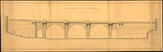 | ||
| Zoom Into Map: | Click on the map to view in greater detail. | |
| Name: | Stevenson, David, 1815-1886 ; Stevenson, Thomas, 1818-1887 | |
| Description: | Edinburgh, North Bridge. Design for widening: west elevations | |
| Year: | 1873 | |
| Place: | Edinburgh, North Bridge | |
| County: | Edinburgh | |
| Subject: | Bridge | |
| Inventory: | Series of 2 drawings | |
| Colour: | Colour | |
| Media: | Hand coloured; Ink | |
| Object: | Folded | |
| Physical: | Paper/Linen/Cloth | |
| Size: | 675 mm x 1992 mm | |
| Shelfmark: | MS.5849, 43 | |
| Show location on map ? | ||
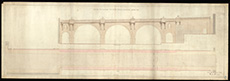 | ||
| Zoom Into Map: | Click on the map to view in greater detail. | |
| Name: | Stevenson, David, 1815-1886 ; Stevenson, Thomas, 1818-1887 | |
| Description: | Edinburgh, Mound. Sections of wall and Iron tie-bars | |
| Year: | 1873 | |
| Place: | Edinburgh, Mound | |
| County: | Edinburgh | |
| Subject: | Building/Monument | |
| Inventory: | Series of 3 drawings | |
| Colour: | Colour | |
| Media: | Hand coloured; Ink | |
| Object: | Flat | |
| Physical: | Paper | |
| Size: | 567 mm x 777 mm | |
| Shelfmark: | MS.5849, 15 -17 | |
| Show location on map ? | ||
| Name: | Stevenson, David, 1815-1886 ; Stevenson, Thomas, 1818-1887 | |
| Description: | Edinburgh, North Bridge. Design fro widening: east elevations | |
| Year: | 1873 | |
| Place: | Edinburgh, North Bridge | |
| County: | Edinburgh | |
| Subject: | Bridge | |
| Inventory: | Series of 2 drawings | |
| Colour: | B&W | |
| Media: | Graphite; Ink | |
| Object: | Folded | |
| Physical: | Paper/Linen/Cloth | |
| Size: | 675 mm x 2005 mm | |
| Shelfmark: | MS.5849, 42 | |
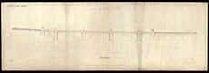 | ||
| Zoom Into Map: | Click on the map to view in greater detail. | |
| Name: | Stevenson, David, 1815-1886 ; Stevenson, Thomas, 1818-1887 | |
| Description: | Edinburgh, North Bridge. Design for widening: west elevations | |
| Year: | 1873 | |
| Place: | Edinburgh, North Bridge | |
| County: | Edinburgh | |
| Subject: | Bridge | |
| Inventory: | Series of 2 drawings | |
| Colour: | Colour | |
| Media: | Graphite; Hand coloured; Ink | |
| Object: | Folded | |
| Physical: | Paper | |
| Size: | 630 mm x 1950 mm | |
| Shelfmark: | MS.5849, 44 | |
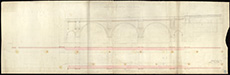 | ||
| Zoom Into Map: | Click on the map to view in greater detail. | |
| Description: | Experiments in Queen's Park. Framework for observation at different heights on the relative velocities of the wind (2 diagrams), 1879. | |
| Year: | 1879 | |
| Place: | Edinburgh, Holyrood Park | |
| County: | Edinburgh | |
| Subject: | Machinery | |
| Colour: | Colour | |
| Media: | None | |
| Object: | Flat | |
| Physical: | Paper | |
| Size: | 560 x 770 mm | |
| Shelfmark: | Acc.10706, 627 | |
| Show location on map ? | ||
 | ||
| Zoom Into Map: | Click on the map to view in greater detail. | |
| Description: | Experiments in Queen's Park. Framework for observation at different heights on the relative velocities of the wind (2 diagrams), 1879. | |
| Year: | 1879 | |
| Place: | Edinburgh, Holyrood Park | |
| County: | Edinburgh | |
| Subject: | Machinery | |
| Colour: | Colour | |
| Media: | None | |
| Object: | Flat | |
| Physical: | Paper | |
| Size: | 1000 x 680 mm | |
| Shelfmark: | Acc.10706, 628 | |
| Show location on map ? | ||
| Name: | Stevenson, David, 1815-1886 ; Stevenson, Thomas, 1818-1887 | |
| Description: | Edinburgh. Extension and sewerage, plans and sections | |
| Year: | 1884-5 | |
| Place: | Edinburgh | |
| County: | Edinburgh | |
| Subject: | Water Supply Works | |
| Inventory: | Prints | |
| Colour: | B&W | |
| Media: | Printed | |
| Object: | Bound | |
| Physical: | Paper | |
| Size: | 545 mm x 762 mm | |
| Shelfmark: | MS.5849, 99 | |
| Show location on map ? | ||
| Name: | Stevenson, David, 1815-1886 ; Stevenson, Thomas, 1818-1887 | |
| Description: | Edinburgh. Extension and sewerage, plans and sections | |
| Year: | 1884-6 | |
| Place: | Edinburgh | |
| County: | Edinburgh | |
| Subject: | Water Supply Works | |
| Inventory: | Prints | |
| Colour: | B&W | |
| Media: | Printed | |
| Object: | Bound | |
| Physical: | Paper | |
| Size: | 545 mm x 762 mm | |
| Shelfmark: | MS.5849, 100 | |
| Show location on map ? | ||
| Name: | Stevenson, John | |
| Description: | Edinburgh: Calton Hill. Site of School House in Greenside Lane | |
| Year: | 1886 | |
| Place: | Edinburgh, Calton Hill | |
| County: | Edinburgh | |
| Subject: | Building/Monument | |
| Inventory: | Drawing | |
| Colour: | Colour | |
| Media: | Hand coloured; Ink | |
| Object: | Flat | |
| Physical: | Paper | |
| Size: | 555 mm x 763 mm | |
| Shelfmark: | MS.5848, 13 | |
| Show location on map ? | ||
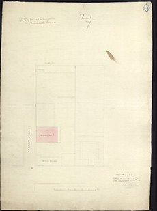 | ||
| Zoom Into Map: | Click on the map to view in greater detail. | |
| Name: | Anderson, Robert Rowand, Sir, 1834-1921 | |
| Description: | Edinburgh, Mound. Ground acquired for erection of Nat. Gallery | |
| Year: | 1892 | |
| Place: | Edinburgh, Mound | |
| County: | Edinburgh | |
| Subject: | Building/Monument | |
| Inventory: | Tracing and 2 drawings | |
| Colour: | B&W | |
| Media: | Ink | |
| Object: | Flat | |
| Physical: | Transparent paper/Paper | |
| Size: | 596 mm x 480 mm | |
| Shelfmark: | MS.5849, 18 | |
| Show location on map ? | ||
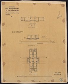 | ||
| Zoom Into Map: | Click on the map to view in greater detail. | |
| Name: | Anderson, Robert Rowand, Sir, 1834-1921 | |
| Description: | Edinburgh, Mound. Doorways | |
| Year: | 1892 | |
| Place: | Edinburgh, Mound | |
| County: | Edinburgh | |
| Subject: | Building/Monument | |
| Inventory: | Tracing | |
| Colour: | B&W | |
| Media: | Ink | |
| Object: | Flat | |
| Physical: | Transparent paper/Paper | |
| Size: | 425 mm x 326 mm | |
| Shelfmark: | MS.5849, 21 | |
| Show location on map ? | ||
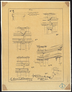 | ||
| Zoom Into Map: | Click on the map to view in greater detail. | |
| Name: | Anderson, Robert Rowand, Sir, 1834-1921 | |
| Description: | Edinburgh, Mound. Ground acquired for erection of Nat. Gallery | |
| Year: | 1892 | |
| Place: | Edinburgh, Mound | |
| County: | Edinburgh | |
| Subject: | Building/Monument | |
| Inventory: | Tracing and 2 drawings | |
| Colour: | Colour | |
| Media: | Graphite; Printed | |
| Object: | Flat | |
| Physical: | Paper | |
| Size: | 446 mm x 288 mm | |
| Shelfmark: | MS.5849, 19 | |
| Name: | Anderson, Robert Rowand, Sir, 1834-1921 | |
| Description: | Edinburgh, Mound. Ground acquired for erection of Nat. Gallery | |
| Year: | 1892 | |
| Place: | Edinburgh, Mound | |
| County: | Edinburgh | |
| Subject: | Building/Monument | |
| Inventory: | Tracing and 2 drawings | |
| Colour: | Colour | |
| Media: | Hand coloured; Printed | |
| Object: | Flat | |
| Physical: | Paper | |
| Size: | 510 mm x 762 mm | |
| Shelfmark: | MS.5849, 20 | |
| Name: | Stevenson, David Alan, 1854-1938 ; Stevenson, Charles Alexander, 1855-1950 | |
| Description: | Edinburgh, Mound. Trigonometrical survey of Nat. Gallery ground | |
| Year: | 1893 | |
| Place: | Edinburgh, Mound | |
| County: | Edinburgh | |
| Subject: | Building/Monument | |
| Inventory: | Drawing | |
| Colour: | B&W | |
| Media: | Ink | |
| Object: | Flat | |
| Physical: | Paper | |
| Size: | 676 mm x 1030 mm | |
| Shelfmark: | MS.5849, 22 | |
| Show location on map ? | ||