Your name search for Stevenson, Robert returned 340 records.
Ordered chronologically (undated items first).
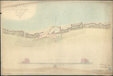
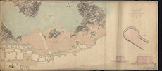
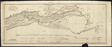
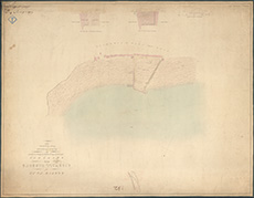
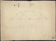
| Name: | Stevenson, Robert, 1772-1850 | |
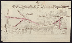
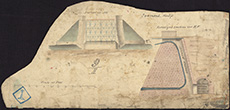
| Description: | Linlithgow. Sketch survey of Turnpike road from Linlithgow to Falkirk at Castle Bridge | |
| Place: | Linlithgow | |
| County: | West Lothian | |
| Subject: | Road | |
| Inventory: | Drawing | |
| Colour: | Colour | |
| Media: | Hand coloured; Ink | |
| Object: | Folded | |
| Physical: | Paper | |
| Size: | 500 mm x 1220 mm | |
| Shelfmark: | MS.5855, 48 | |
| Show location on map ? | ||
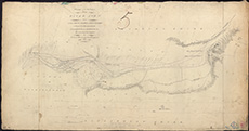
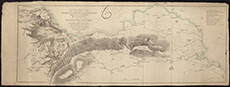
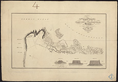
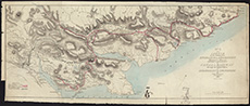
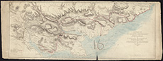
| Name: | Stevenson, Robert, 1772-1850 | |
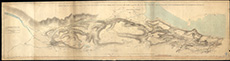
| Description: | Eastern coast from Stonehaven to Troup Head | |
| County: | Aberdeen ; Banff ; Kincardine | |
| Subject: | Reference Material | |
| Inventory: | Drawing | |
| Colour: | B&W | |
| Object: | Folded | |
| Physical: | Card | |
| Size: | 940 x 1600 mm | |
| Shelfmark: | MS.5862, 59 | |
| Show location on map ? | ||
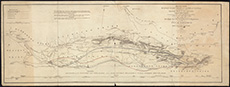
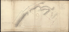
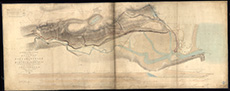
| Name: | Stevenson, Robert, 1772-1850 | |
| Description: | Edinburgh and Glasgow Railway. Survey of a proposed line of railway between Edinburgh and Glasgow. Robert Stevenson, 1825, 1826, 1830, 1831. | |
| County: | Dunbarton ; Edinburgh ; Lanark ; Renfrew ; Stirling ; West Lothian | |
| Subject: | Railway | |
| Colour: | Colour | |
| Media: | Linen/Cloth | |
| Object: | Folded | |
| Physical: | Paper | |
| Size: | 720 x 3600 mm | |
| Shelfmark: | Acc.10706, 422 | |
| Show location on map ? | ||
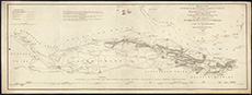
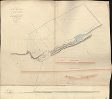
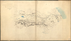
| Name: | Stevenson, Robert, 1772-1850 | |
| Description: | Railways. Sketch plan of the shires of Kincardine, Forfar, Perth, Fife, Stirling...Selkirk and Peebles with sections showing several lines of railway or canal surveyed or levelled between the years 1817 and 1820 by Robert Stevenson. (torn composite map). | |
| County: | Aberdeen ; Berwick ; Clackmannan ; Dunbarton ; East Lothian ; Edinburgh ; Fife ; Forfar ; Kincardine ; Kinross ; Lanark ; Peebles ; Perth ; Renfrew ; Roxburgh ; Selkirk ; Stirling ; West Lothian | |
| Subject: | Railway | |
| Colour: | Colour | |
| Media: | None | |
| Object: | Folded | |
| Physical: | Paper | |
| Size: | 1420 x 1600 mm | |
| Shelfmark: | Acc.10706, 460 | |
| Show location on map ? | ||
| Name: | Stevenson, Robert, 1772-1850 | |
| Description: | Roads and Bridges - Edinburgh. Sketch showing the western line of approach to the City of Edinburgh proposed by Mr Stevenson, n.d. | |
| Place: | Edinburgh, Calton Hill | |
| County: | Edinburgh | |
| Subject: | Road | |
| Colour: | Colour | |
| Media: | None | |
| Object: | Flat | |
| Physical: | Paper | |
| Size: | 145 x 240 mm | |
| Shelfmark: | Acc.10706, 462 | |
| Show location on map ? | ||
 | ||
| Zoom Into Map: | Click on the map to view in greater detail. | |
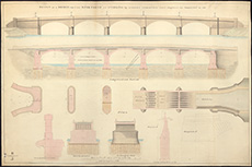
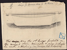
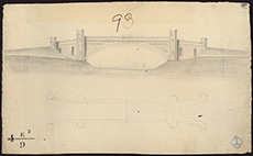
| Name: | Stevenson, Robert, 1772-1850 | |
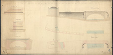
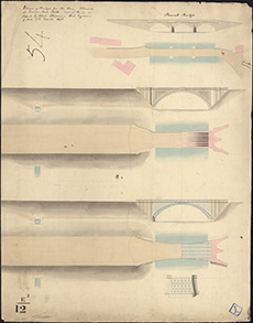
| Description: | Roads and Bridges - Stirling Bridge. Design of a bridge over the River Forth at Stirling. Robert Stevenson, 1829, completed in 1832. | |
| Place: | Stirling | |
| County: | Stirling | |
| Subject: | Bridge | |
| Colour: | Colour | |
| Media: | None | |
| Object: | Flat | |
| Physical: | Paper | |
| Size: | 640 x 965 mm | |
| Shelfmark: | Acc.10706, 504 | |
| Show location on map ? | ||
 | ||
| Zoom Into Map: | Click on the map to view in greater detail. | |
| Name: | Stevenson, Robert, 1772-1850 | |
| Description: | Arbroath Abbey. Sketch and Drawings to accompany report – Robert Stevenson (1804) (2 drawings) | |
| Year: | 1804 | |
| Place: | Arbroath | |
| County: | Forfar | |
| Subject: | Building/Monument | |
| Colour: | Colour | |
| Media: | None | |
| Object: | Folded | |
| Physical: | Paper | |
| Size: | 605 x 1200 mm | |
| Shelfmark: | Acc.10706, 672 | |
| Name: | Stevenson, Robert, 1772-1850 | |
| Description: | Arbroath Abbey. Sketch and Drawings to accompany report – Robert Stevenson (1804) (2 drawings) | |
| Year: | 1804 | |
| Place: | Arbroath | |
| County: | Forfar | |
| Subject: | Building/Monument | |
| Colour: | Colour | |
| Media: | None | |
| Object: | Folded | |
| Physical: | Paper | |
| Size: | 460 x 1750 mm | |
| Shelfmark: | Acc.10706, 673 | |
| Name: | Stevenson, Robert, 1772-1850 | |
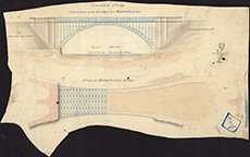
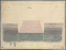
| Description: | Roads and Bridges - Mary Kirk. Section of the embankment for the bridge at Mary Kirk, signed Robert Stevenson, 1811. | |
| Year: | 1811 | |
| Place: | Mary Kirk | |
| County: | Forfar ; Kincardine | |
| Subject: | Bridge | |
| Colour: | Colour | |
| Media: | Linen/Cloth | |
| Object: | Folded | |
| Physical: | Paper | |
| Size: | 555 x 835 mm | |
| Shelfmark: | Acc.10706, 488 | |
| Show location on map ? | ||
 | ||
| Zoom Into Map: | Click on the map to view in greater detail. | |
| Name: | Stevenson, Robert, 1772-1850 | |
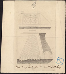
| Description: | Roads and Bridges - North Esk. Design of a bridge for the North Esk, Kincardineshire. Robert Stevenson, 1811. | |
| Year: | 1811 | |
| County: | Forfar | |
| Subject: | Bridge | |
| Colour: | Colour | |
| Media: | Linen/Cloth | |
| Object: | Flat | |
| Physical: | Paper | |
| Size: | 560 x 840 mm | |
| Shelfmark: | Acc.10706, 493 | |
| Show location on map ? | ||
 | ||
| Zoom Into Map: | Click on the map to view in greater detail. | |
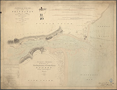
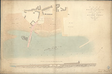
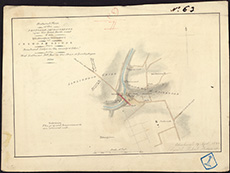
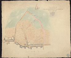
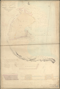
| Name: | Stevenson, Robert, 1772-1850 | |
| Description: | Stonehaven Harbour. Plan of a Harbour for Stonehaven in the County of Kincardine calculated to admit Ships of War, Robert Stevenson, 1812 | |
| Year: | 1812 | |
| Place: | Stonehaven | |
| County: | Kincardine | |
| Subject: | Harbour | |
| Colour: | Colour | |
| Media: | None | |
| Object: | Folded | |
| Physical: | Paper | |
| Size: | 955 x 660 mm | |
| Shelfmark: | Acc.10706, 696 | |
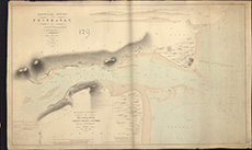
| Name: | Stevenson, Robert, 1772-1850 | |
| Description: | Stonehaven Harbour. Plan for enlarging the Harbour of Stonehaven, Robert Stevenson, 1812 | |
| Year: | 1812 | |
| Place: | Stonehaven | |
| County: | Kincardine | |
| Subject: | Harbour | |
| Colour: | Colour | |
| Media: | None | |
| Object: | Folded | |
| Physical: | Paper | |
| Size: | 990 x 660 mm | |
| Shelfmark: | Acc.10706, 697 | |
| Name: | Stevenson, Robert, 1772-1850 | |
| Description: | Harbours - Portpatrick. Plan for enlarging and improving the harbour and for extending the lighthouse, Robert Stevenson, 1812. (copied 1817). | |
| Year: | 1812 | |
| Place: | Portpatrick | |
| County: | Wigtown | |
| Subject: | Harbour | |
| Colour: | B&W | |
| Media: | None | |
| Object: | Flat | |
| Physical: | Paper | |
| Size: | 500 x 920 mm | |
| Shelfmark: | Acc.10706, 296 | |
| Show location on map ? | ||
| Name: | Stevenson, Robert, 1772-1850 | |
| Description: | Edinburgh: Canonmills. Design for bridge | |
| Year: | 1813 | |
| Place: | Edinburgh, Canonmills | |
| County: | Edinburgh | |
| Subject: | Bridge | |
| Inventory: | Drawing | |
| Colour: | B&W | |
| Media: | Graphite | |
| Object: | Flat | |
| Physical: | Paper | |
| Size: | 555 mm x 445 mm | |
| Shelfmark: | MS.5848, 17 | |
| Show location on map ? | ||
| Name: | Stevenson, Robert, 1772-1850 | |
| Description: | Cellardyke. Harbour | |
| Year: | 1814 | |
| Place: | Cellardyke | |
| County: | Fife | |
| Subject: | Harbour | |
| Inventory: | Drawing | |
| Colour: | Colour | |
| Media: | Hand coloured; Ink | |
| Object: | Flat | |
| Physical: | Paper | |
| Size: | 500 mm x 640 mm | |
| Shelfmark: | MS.5846, 39 | |
| Show location on map ? | ||
| Name: | Stevenson, Robert, 1772-1850 | |
| Description: | Esk, River, North. Parts of river, and dams of Mills of Kinnaber & Morphie | |
| Year: | 1814 | |
| County: | Forfar ; Kincardine | |
| Subject: | River | |
| Inventory: | Drawing | |
| Colour: | B&W | |
| Media: | Graphite; Hand coloured; Ink | |
| Object: | Flat | |
| Physical: | Paper | |
| Size: | 560 mm x 975 mm | |
| Shelfmark: | MS.5849, 118 | |
| Show location on map ? | ||
| Name: | Stevenson, Robert, 1772-1850 | |
| Description: | Forth & Clyde Canal. Sketch of country between Edin, & Glasgow showing canal | |
| Year: | 1814 | |
| County: | Dunbarton ; Edinburgh ; Fife ; Lanark ; Renfrew ; Stirling ; West Lothian | |
| Subject: | Canal | |
| Inventory: | Series of 2 drawings and 1 reduced copy | |
| Colour: | Colour | |
| Media: | Hand coloured; Ink | |
| Object: | Folded | |
| Physical: | Paper/Linen/Cloth | |
| Size: | 582 mm x 2250 mm | |
| Shelfmark: | MS.5850, 54 - Mc | |
| Show location on map ? | ||
 | ||
| Zoom Into Map: | Click on the map to view in greater detail. | |
| Name: | Stevenson, Robert, 1772-1850 | |
| Description: | Forth & Clyde Canal. Sketch of country between Edin, & Glasgow showing canal | |
| Year: | 1814 | |
| County: | Dunbarton ; Edinburgh ; Fife ; Lanark ; Renfrew ; Stirling ; West Lothian | |
| Subject: | Canal | |
| Inventory: | Series of 2 drawings and 1 reduced copy | |
| Colour: | Colour | |
| Media: | Hand coloured; Ink | |
| Object: | Folded | |
| Physical: | Paper/Linen/Cloth | |
| Size: | 540 mm x 1920 mm | |
| Shelfmark: | MS.5850, 55 - Mc | |
| Show location on map ? | ||
| Name: | Stevenson, Robert, 1772-1850 | |
| Description: | Forth & Clyde Canal. Sketch of country between Edin, & Glasgow showing canal | |
| Year: | 1814 | |
| County: | Dunbarton ; Edinburgh ; Fife ; Lanark ; Renfrew ; Stirling ; West Lothian | |
| Subject: | Canal | |
| Inventory: | Series of 2 drawings and 1 reduced copy | |
| Colour: | Colour | |
| Media: | Hand coloured; Ink | |
| Object: | Flat | |
| Physical: | Paper | |
| Size: | 535 mm x 1260 mm | |
| Shelfmark: | MS.5850, 56 - Mc | |
| Show location on map ? | ||
| Name: | Stevenson, Robert, 1772-1850 | |
| Description: | Westbarns. Survey of Mills | |
| Year: | 1814 | |
| Place: | Westbarns | |
| County: | East Lothian | |
| Subject: | Building/Monument | |
| Inventory: | Drawing | |
| Colour: | Colour | |
| Media: | None | |
| Object: | Folded | |
| Physical: | Card | |
| Size: | 610 x 1030 mm | |
| Shelfmark: | MS.5864, 1 | |
| Show location on map ? | ||
 | ||
| Zoom Into Map: | Click on the map to view in greater detail. | |
| Name: | Stevenson, Robert, 1772-1850 | |
| Description: | Roads and Bridges - Edinburgh. Survey of the lands of Calton Hill and design for a new approach to the City of Edinburgh...signed Robert Stevenson, 1814. | |
| Year: | 1814 | |
| Place: | Edinburgh, Calton Hill | |
| County: | Edinburgh | |
| Subject: | Road | |
| Colour: | Colour | |
| Media: | Linen/Cloth | |
| Object: | Folded | |
| Physical: | Paper | |
| Size: | 755 x 1280 mm | |
| Shelfmark: | Acc.10706, 464 | |
| Show location on map ? | ||
| Name: | Stevenson, Robert, 1772-1850 | |
| Description: | Roads and Bridges - Edinburgh. Plan of the lands of Calton Hill and design for a new approach to the City of Edinburgh by a bridge over Calton Street. Robert Stevenson, 1814. | |
| Year: | 1814 | |
| Place: | Edinburgh, Calton Hill | |
| County: | Edinburgh | |
| Subject: | Road | |
| Colour: | Colour | |
| Media: | Linen/Cloth | |
| Object: | Folded | |
| Physical: | Paper | |
| Size: | 650 x 990 mm | |
| Shelfmark: | Acc.10706, 465 | |
| Show location on map ? | ||
 | ||
| Zoom Into Map: | Click on the map to view in greater detail. | |
| Name: | Stevenson, Robert, 1772-1850 | |
| Description: | Westbarns. Survey and sections of mills | |
| Year: | 1815 | |
| Place: | Westbarns | |
| County: | East Lothian | |
| Subject: | Building/Monument | |
| Inventory: | Drawing | |
| Colour: | Colour | |
| Media: | Linen/Cloth | |
| Object: | Folded | |
| Physical: | Card | |
| Size: | 740 x 1290 mm | |
| Shelfmark: | MS.5864, 2 | |
| Show location on map ? | ||
 | ||
| Zoom Into Map: | Click on the map to view in greater detail. | |
| Name: | Stevenson, Robert, 1772-1850 | |
| Description: | St. Andrews. Sections of piers for new harbour | |
| Year: | 1815 | |
| Place: | St. Andrews | |
| County: | Fife | |
| Subject: | Harbour | |
| Inventory: | Series of 3 drawings | |
| Colour: | Colour | |
| Media: | None | |
| Object: | Flat | |
| Physical: | Card | |
| Size: | 510 x 600 mm | |
| Shelfmark: | MS.5862, 1 | |
| Show location on map ? | ||
| Name: | Stevenson, Robert, 1772-1850 | |
| Description: | Lasswade. Survey of village with proposed new road | |
| Year: | 1815 | |
| Place: | Lasswade | |
| County: | Edinburgh | |
| Subject: | Road | |
| Inventory: | Drawing | |
| Colour: | Colour | |
| Media: | Hand coloured; Ink | |
| Object: | Flat | |
| Physical: | Paper/Linen/Cloth | |
| Size: | 850 mm x 1300 mm | |
| Shelfmark: | MS.5855, 5 | |
| Show location on map ? | ||
| Name: | Stevenson, Robert, 1772-1850 | |
| Description: | Lugton. Plan and section of Bridge and Tunnel for Mill Lead | |
| Year: | 1815 | |
| Place: | Lugton | |
| County: | Ayr | |
| Subject: | Bridge | |
| Inventory: | Drawing | |
| Colour: | Colour | |
| Media: | Hand coloured; Ink | |
| Object: | Folded | |
| Physical: | Paper/Linen/Cloth | |
| Size: | 630 mm x 1260 mm | |
| Shelfmark: | MS.5855, 83 | |
| Show location on map ? | ||
 | ||
| Zoom Into Map: | Click on the map to view in greater detail. | |
| Name: | Stevenson, Robert, 1772-1850 | |
| Description: | Lugton. Bridge & proposed improvements | |
| Year: | 1815 | |
| Place: | Lugton | |
| County: | Ayr | |
| Subject: | Bridge | |
| Inventory: | Drawing | |
| Colour: | Colour | |
| Media: | Hand coloured; Ink | |
| Object: | Folded | |
| Physical: | Paper | |
| Size: | 595 mm x 3360 mm | |
| Shelfmark: | MS.5855, 84 | |
| Show location on map ? | ||
| Name: | Stevenson, Robert, 1772-1850 | |
| Description: | St. Andrews. Sections of piers for new harbour | |
| Year: | 1816 | |
| Place: | St. Andrews | |
| County: | Fife | |
| Subject: | Harbour | |
| Inventory: | Series of 3 drawings | |
| Colour: | Colour | |
| Media: | None | |
| Object: | Flat | |
| Physical: | Paper | |
| Size: | 670 x 520 mm | |
| Shelfmark: | MS.5862, 2 | |
| Show location on map ? | ||
| Name: | Stevenson, Robert, 1772-1850 | |
| Description: | Montrose. Reduced plan and sections of harbour and part of town showing proposed improvements | |
| Year: | 1816 | |
| Place: | Montrose | |
| County: | Forfar | |
| Subject: | Harbour | |
| Inventory: | Drawing | |
| Colour: | Colour | |
| Media: | Hand coloured; Printed | |
| Object: | Folded | |
| Physical: | Paper | |
| Size: | 205 mm x 605 mm | |
| Shelfmark: | MS.5856, 34 | |
| Show location on map ? | ||
| Name: | Stevenson, Robert, 1772-1850 | |
| Description: | Drains. Sketch of part of the Grounds of North Loch showing the proposed improvements, Robert Stevenson, 1816. | |
| Year: | 1816 | |
| County: | Edinburgh | |
| Subject: | Water Supply Works | |
| Colour: | B&W | |
| Media: | None | |
| Object: | Folded | |
| Physical: | Paper | |
| Size: | 1335 x 700 mm | |
| Shelfmark: | Acc.10706, 289 | |
| Show location on map ? | ||
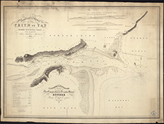
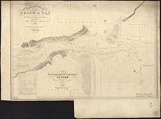
| Name: | Stevenson, Robert, 1772-1850; Steedman, John | |
| Description: | Tay, River. Nautical survey of Firth of Tay | |
| Year: | 1816 | |
| County: | Perth | |
| Subject: | Reference Material | |
| Inventory: | Series of 10 prints by T. Ivory | |
| Colour: | Colour | |
| Media: | Linen/Cloth | |
| Object: | Flat | |
| Physical: | Paper | |
| Size: | 640 x 840 mm | |
| Shelfmark: | MS.5863, 7 | |
| Show location on map ? | ||
 | ||
| Zoom Into Map: | Click on the map to view in greater detail. | |
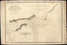
| Name: | Stevenson, Robert, 1772-1850; Steedman, John | |
| Description: | Tay, River. Nautical survey of Firth of Tay | |
| Year: | 1816 | |
| County: | Perth | |
| Subject: | Reference Material | |
| Inventory: | Series of 10 prints by T. Ivory | |
| Colour: | Colour | |
| Media: | None | |
| Object: | Folded | |
| Physical: | Card | |
| Size: | 725 x 1180 mm | |
| Shelfmark: | MS.5863, 8 | |
| Show location on map ? | ||
 | ||
| Zoom Into Map: | Click on the map to view in greater detail. | |
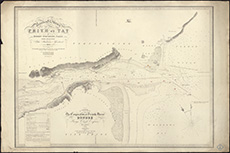
| Name: | Stevenson, Robert, 1772-1850; Steedman, John | |
| Description: | Tay, River. Nautical survey of Firth of Tay | |
| Year: | 1816 | |
| County: | Perth | |
| Subject: | Reference Material | |
| Inventory: | Series of 10 prints by T. Ivory | |
| Colour: | Colour | |
| Media: | None | |
| Object: | Flat | |
| Physical: | Card | |
| Size: | 680 x 1010 mm | |
| Shelfmark: | MS.5863, 9 | |
| Show location on map ? | ||
| Name: | Stevenson, Robert, 1772-1850; Steedman, John | |
| Description: | Tay, River. Nautical survey of Firth of Tay | |
| Year: | 1816 | |
| County: | Perth | |
| Subject: | Reference Material | |
| Inventory: | Series of 10 prints by T. Ivory | |
| Colour: | B&W | |
| Media: | None | |
| Object: | Flat | |
| Physical: | Card | |
| Size: | 670 x 1010 mm | |
| Shelfmark: | MS.5863, 10 | |
| Show location on map ? | ||
| Name: | Stevenson, Robert, 1772-1850; Steedman, John | |
| Description: | Tay, River. Nautical survey of Firth of Tay | |
| Year: | 1816 | |
| County: | Perth | |
| Subject: | Reference Material | |
| Inventory: | Series of 10 prints by T. Ivory | |
| Colour: | Colour | |
| Media: | None | |
| Object: | Flat | |
| Physical: | Card | |
| Size: | 675 x 1010 mm | |
| Shelfmark: | MS.5863, 11 | |
| Show location on map ? | ||
| Name: | Stevenson, Robert, 1772-1850; Steedman, John | |
| Description: | Tay, River. Nautical survey of Firth of Tay | |
| Year: | 1816 | |
| County: | Perth | |
| Subject: | Reference Material | |
| Inventory: | Series of 10 prints by T. Ivory | |
| Colour: | B&W | |
| Media: | None | |
| Object: | Flat | |
| Physical: | Card | |
| Size: | 670 x 900 mm | |
| Shelfmark: | MS.5863, 12 | |
| Show location on map ? | ||
 | ||
| Zoom Into Map: | Click on the map to view in greater detail. | |
| Name: | Stevenson, Robert, 1772-1850; Steedman, John | |
| Description: | Tay, River. Nautical survey of Firth of Tay | |
| Year: | 1816 | |
| County: | Perth | |
| Subject: | Reference Material | |
| Inventory: | Series of 10 prints by T. Ivory | |
| Colour: | B&W | |
| Media: | Linen/Cloth | |
| Object: | Flat | |
| Physical: | Card | |
| Size: | 700 x 950 mm | |
| Shelfmark: | MS.5863, 13 | |
| Show location on map ? | ||
 | ||
| Zoom Into Map: | Click on the map to view in greater detail. | |
| Name: | Stevenson, Robert, 1772-1850; Steedman, John | |
| Description: | Tay, River. Nautical survey of Firth of Tay | |
| Year: | 1816 | |
| County: | Perth | |
| Subject: | Reference Material | |
| Inventory: | Series of 10 prints by T. Ivory | |
| Colour: | B&W | |
| Media: | None | |
| Object: | Flat | |
| Physical: | Card | |
| Size: | 680 x 1000 mm | |
| Shelfmark: | MS.5863, 14 | |
| Show location on map ? | ||
 | ||
| Zoom Into Map: | Click on the map to view in greater detail. | |
| Name: | Stevenson, Robert, 1772-1850; Steedman, John | |
| Description: | Tay, River. Nautical survey of Firth of Tay | |
| Year: | 1816 | |
| County: | Perth | |
| Subject: | Reference Material | |
| Inventory: | Series of 10 prints by T. Ivory | |
| Colour: | Colour | |
| Media: | None | |
| Object: | Flat | |
| Physical: | Card | |
| Size: | 670 x 1010 mm | |
| Shelfmark: | MS.5863, 15 | |
| Show location on map ? | ||
| Name: | Stevenson, Robert, 1772-1850; Steedman, John | |
| Description: | Tay, River. Nautical survey of Firth of Tay | |
| Year: | 1816 | |
| County: | Perth | |
| Subject: | Reference Material | |
| Inventory: | Series of 10 prints by T. Ivory | |
| Colour: | Colour | |
| Media: | None | |
| Object: | Flat | |
| Physical: | Card | |
| Size: | 665 x 1010 mm | |
| Shelfmark: | MS.5863, 16 | |
| Show location on map ? | ||
 | ||
| Zoom Into Map: | Click on the map to view in greater detail. | |
| Name: | Stevenson, Robert, 1772-1850; Steedman, John | |
| Description: | Tay, River. Part of Firth-Ferry between Fife and Forfar | |
| Year: | 1816 | |
| County: | Fife ; Forfar | |
| Subject: | River | |
| Inventory: | Series of 2 prints by J & G Menzies | |
| Colour: | B&W | |
| Media: | None | |
| Object: | Flat | |
| Physical: | Card | |
| Size: | 555 x 750 mm | |
| Shelfmark: | MS.5863, 17 | |
| Show location on map ? | ||
 | ||
| Zoom Into Map: | Click on the map to view in greater detail. | |
| Name: | Stevenson, Robert, 1772-1850; Steedman, John | |
| Description: | Tay, River. Part of Firth-Ferry between Fife and Forfar | |
| Year: | 1816 | |
| County: | Fife ; Forfar | |
| Subject: | River | |
| Inventory: | Series of 2 prints by J & G Menzies | |
| Colour: | Colour | |
| Media: | None | |
| Object: | Flat | |
| Physical: | Card | |
| Size: | 365 x 735 mm | |
| Shelfmark: | MS.5863, 18 | |
| Show location on map ? | ||
| Name: | Stevenson, Robert, 1772-1850 | |
| Description: | Avon River. Survey from Linlithgow Bridge to Emanuel Abbey | |
| Year: | 1816 | |
| County: | Stirling ; West Lothian | |
| Subject: | River | |
| Inventory: | Drawing | |
| Colour: | B&W | |
| Media: | Graphite; Hand coloured; Ink | |
| Object: | Flat | |
| Physical: | Paper | |
| Size: | 557 mm x 1066 mm | |
| Shelfmark: | MS.5844, 142 | |
| Show location on map ? | ||
 | ||
| Zoom Into Map: | Click on the map to view in greater detail. | |
| Name: | Stevenson, Robert, 1772-1850 | |
| Description: | East Haven. Survey of harbour of East and West Haven | |
| Year: | 1817 | |
| Place: | East Haven | |
| County: | Forfar | |
| Subject: | Harbour | |
| Inventory: | Drawing | |
| Colour: | B&W | |
| Media: | Ink | |
| Object: | Folded | |
| Physical: | Paper | |
| Size: | 570 mm x 1065 mm | |
| Shelfmark: | MS.5848, 3 | |
| Show location on map ? | ||
| Name: | Stevenson, Robert, 1772-1850 | |
| Description: | Arbroath. Line of Canal to connect Arbroath with Forfar | |
| Year: | 1817 | |
| Place: | Arbroath | |
| County: | Forfar | |
| Subject: | Canal | |
| Inventory: | Drawing | |
| Media: | Hand coloured; Ink | |
| Object: | Folded | |
| Physical: | Paper/Linen/Cloth | |
| Size: | 760 mm x 1780 mm | |
| Shelfmark: | Mc.5844, 114 | |
| Show location on map ? | ||
| Name: | Stevenson, Robert, 1772-1850 | |
| Description: | Forfar. Survey and section of canal from Forfar to Arbroath | |
| Year: | 1817 | |
| Place: | Forfar | |
| County: | Forfar | |
| Subject: | Canal | |
| Inventory: | Drawing | |
| Colour: | Colour | |
| Media: | Hand coloured; Ink | |
| Object: | Folded | |
| Physical: | Paper/Linen/Cloth | |
| Size: | 765 mm x 1740 mm | |
| Shelfmark: | MS.5850, 31 - Mc | |
| Show location on map ? | ||
| Name: | Stevenson, Robert, 1772-1850 | |
| Description: | Grangemouth. Survey of town with proposed Harbour improvements | |
| Year: | 1817 | |
| Place: | Grangemouth | |
| County: | Stirling | |
| Subject: | Harbour | |
| Inventory: | Drawing | |
| Colour: | Colour | |
| Media: | Graphite; Hand coloured; Ink | |
| Object: | Folded | |
| Physical: | Paper | |
| Size: | 950 mm x 1080 mm | |
| Shelfmark: | MS.5851, 101 | |
| Show location on map ? | ||
| Name: | Stevenson, Robert, 1772-1850 | |
| Description: | Grangemouth. Proposed now timber basin | |
| Year: | 1817 | |
| Place: | Grangemouth | |
| County: | Stirling | |
| Subject: | Harbour | |
| Inventory: | Drawing | |
| Colour: | B&W | |
| Media: | Ink | |
| Object: | Flat | |
| Physical: | Transparent paper/Paper | |
| Size: | 268 mm x 353 mm | |
| Shelfmark: | MS.5851, 102 | |
| Show location on map ? | ||
 | ||
| Zoom Into Map: | Click on the map to view in greater detail. | |
| Name: | Stevenson, Robert, 1772-1850 | |
| Description: | Edinburgh and Glasgow Canal. Reduced Survey and Section of a line canal between Edinburgh and Glasgow ... by Robert Stevenson, 1817. Printed. (marked) | |
| Year: | 1817 | |
| County: | Ayr ; Dunbarton ; Edinburgh ; Fife ; Lanark ; Renfrew ; Stirling ; West Lothian | |
| Subject: | Canal | |
| Colour: | Colour | |
| Media: | None | |
| Object: | Flat | |
| Physical: | Paper | |
| Size: | 278 x 751 mm | |
| Shelfmark: | Acc.10706, 275 | |
| Show location on map ? | ||
 | ||
| Zoom Into Map: | Click on the map to view in greater detail. | |
| Name: | Stevenson, Robert, 1772-1850 | |
| Description: | Edinburgh and Glasgow Canal. Reduced Survey and Section of a line of canal between Edinburgh and Glasgow ... by Robert Stevenson, 1817. Printed. (unmarked) | |
| Year: | 1817 | |
| County: | Ayr ; Dunbarton ; Edinburgh ; Fife ; Lanark ; Renfrew ; Stirling ; West Lothian | |
| Subject: | Canal | |
| Colour: | Colour | |
| Media: | None | |
| Object: | Flat | |
| Physical: | Paper | |
| Size: | 278 x 753 mm | |
| Shelfmark: | Acc.10706, 276 | |
| Show location on map ? | ||
 | ||
| Zoom Into Map: | Click on the map to view in greater detail. | |
| Name: | Stevenson, Robert, 1772-1850 | |
| Description: | Tyne, River. Haddiongton to Gimes Mill showing position of Newbridge | |
| Year: | 1817 | |
| County: | East Lothian | |
| Subject: | Bridge | |
| Inventory: | Drawing | |
| Colour: | B&W | |
| Media: | None | |
| Object: | Folded | |
| Physical: | Card | |
| Size: | 565 x 1300 mm | |
| Shelfmark: | MS.5863, 120 | |
| Show location on map ? | ||
| Name: | Stevenson, Robert, 1772-1850 | |
| Description: | Roads and Bridges - Edinburgh. Plan of Princes Street and Regent Street signed Robert Stevenson, 1817. | |
| Year: | 1817 | |
| Place: | Edinburgh, Princes Street | |
| County: | Edinburgh | |
| Subject: | Road | |
| Colour: | Colour | |
| Media: | None | |
| Object: | Folded | |
| Physical: | Paper | |
| Size: | 285 x 3200 mm | |
| Shelfmark: | Acc.10706, 469 | |
| Show location on map ? | ||
 | ||
| Zoom Into Map: | Click on the map to view in greater detail. | |
| Name: | Stevenson, Robert, 1772-1850 | |
| Description: | Newport. Survey for harbour and plans for improvement | |
| Year: | 1817 | |
| Place: | Newport | |
| County: | Fife | |
| Subject: | Harbour | |
| Inventory: | Series of 2 drawings | |
| Colour: | Colour | |
| Media: | Hand coloured; Ink | |
| Object: | Flat | |
| Physical: | Paper | |
| Size: | 560 mm x 1030 mm | |
| Shelfmark: | MS.5857, 16 | |
| Show location on map ? | ||
| Name: | Stevenson, Robert, 1772-1850 | |
| Description: | St. Andrews. Sections of piers for new harbour | |
| Year: | 1817 | |
| Place: | St. Andrews | |
| County: | Fife | |
| Subject: | Harbour | |
| Inventory: | Series of 3 drawings | |
| Colour: | Colour | |
| Media: | None | |
| Object: | Flat | |
| Physical: | Card | |
| Size: | 665 x 525 mm | |
| Shelfmark: | MS.5862, 3 | |
| Show location on map ? | ||
| Name: | Stevenson, Robert, 1772-1850 | |
| Description: | Newport. Survey for harbour and plans for improvement | |
| Year: | 1818 | |
| Place: | Newport | |
| County: | Fife | |
| Subject: | Harbour | |
| Inventory: | Series of 2 drawings | |
| Colour: | Colour | |
| Media: | Hand coloured; Ink | |
| Object: | Flat | |
| Physical: | Paper/Linen/Cloth | |
| Size: | 630 mm x 930 mm | |
| Shelfmark: | MS.5857, 17 | |
| Show location on map ? | ||
 | ||
| Zoom Into Map: | Click on the map to view in greater detail. | |
| Name: | Stevenson, Robert, 1772-1850 | |
| Description: | Perth. Part of city, for supply of water from the Tay | |
| Year: | 1818 | |
| Place: | Perth | |
| County: | Perth | |
| Subject: | Water Supply Works | |
| Inventory: | Drawing. For map of Perth of 1809 see No. 43 | |
| Colour: | Colour | |
| Media: | Hand coloured; Ink | |
| Object: | Folded | |
| Physical: | Paper/Linen/Cloth | |
| Size: | 660 mm x 1300 mm | |
| Shelfmark: | MS.5859, 8 | |
| Show location on map ? | ||
| Name: | Stevenson, Robert, 1772-1850 | |
| Description: | Edinburgh to Mid and East Lothian coalfields Railway. Plan and section of proposed railway line from Edinburgh to the coalfields of Mid and East Lothian. Robert Stevenson, 1818. | |
| Year: | 1818 | |
| County: | East Lothian ; Edinburgh | |
| Subject: | Railway | |
| Colour: | Colour | |
| Media: | Linen/Cloth | |
| Object: | Folded | |
| Physical: | Paper | |
| Size: | 765 x 2000 mm | |
| Shelfmark: | Acc.10706, 425 | |
| Show location on map ? | ||
| Name: | Stevenson, Robert, 1772-1850 | |
| Description: | Edinburgh to Mid and East Lothian coalfields Railway. Reduced engraved plan showing proposed railway line from Edinburgh to the coalfields of Mid and East Lothian, surveyed by Robert Stevenson, 1818. | |
| Year: | 1818 | |
| County: | East Lothian ; Edinburgh | |
| Subject: | Railway | |
| Colour: | Colour | |
| Media: | None | |
| Object: | Flat | |
| Physical: | Paper | |
| Size: | 285 x 770 mm | |
| Shelfmark: | Acc.10706, 427 | |
| Show location on map ? | ||
 | ||
| Zoom Into Map: | Click on the map to view in greater detail. | |
| Name: | Stevenson, Robert, 1772-1850 | |
| Description: | Railways. Section plan and sections of railway line from Newton Colliery to John's Mains through the Lands of Edmonston, Robert Stevenson, 1818. | |
| Year: | 1818 | |
| County: | Edinburgh | |
| Subject: | Railway | |
| Colour: | Colour | |
| Media: | None | |
| Object: | Folded | |
| Physical: | Paper | |
| Size: | 560 x 1210 mm | |
| Shelfmark: | Acc.10706, 446 | |
| Show location on map ? | ||
 | ||
| Zoom Into Map: | Click on the map to view in greater detail. | |
| Name: | Stevenson, Robert, 1772-1850 | |
| Description: | Dundee Harbour. Plan of the Harbour of Dundee shewing the proposed Boat Harbour at the Craig Pier, Robert Stevenson, 1818 | |
| Year: | 1818 | |
| Place: | Dundee | |
| County: | Forfar | |
| Subject: | Harbour | |
| Colour: | Colour | |
| Media: | None | |
| Object: | Folded | |
| Physical: | Paper | |
| Size: | 645 x 980 mm | |
| Shelfmark: | Acc.10706, 681 | |
| Name: | Stevenson, Robert, 1772-1850 | |
| Description: | Pow of Errol. Sections showing proposed improvements on Harbour Mill Lead and Dam | |
| Year: | 1818 | |
| Place: | Pow of Errol | |
| County: | Perth | |
| Subject: | Harbour | |
| Inventory: | Drawing | |
| Colour: | Colour | |
| Media: | None | |
| Object: | Flat | |
| Physical: | Card | |
| Size: | 930 x 1040 mm | |
| Shelfmark: | MS.5859, 149 | |
| Show location on map ? | ||
 | ||
| Zoom Into Map: | Click on the map to view in greater detail. | |
| Name: | Stevenson, Robert, 1772-1850 | |
| Description: | Harbours - Leith. Sketch plan of the Harbour & Town of Leith ... referred to in a report by Robert Stevenson, 1818. | |
| Year: | 1818 | |
| Place: | Leith | |
| County: | Edinburgh | |
| Subject: | Harbour | |
| Colour: | Colour | |
| Media: | None | |
| Object: | Flat | |
| Physical: | Paper | |
| Size: | 560 x 1160 mm | |
| Shelfmark: | Acc.10706, 295 | |
| Show location on map ? | ||
| Name: | Stevenson, Robert, 1772-1850 | |
| Description: | Fife. Map of the coastline near Fife | |
| Year: | 1818 | |
| County: | Fife | |
| Subject: | Reference Material | |
| Inventory: | Drawing | |
| Colour: | B&W | |
| Media: | Graphite; Hand coloured; Ink | |
| Object: | Flat | |
| Physical: | Paper | |
| Size: | 850 mm x 570 mm | |
| Shelfmark: | MS.5850, 1 | |
| Show location on map ? | ||
| Name: | Stevenson, Robert, 1772-1850 | |
| Description: | Fraserburgh. Sketch plan of new southern pier for harbour | |
| Year: | 1818 | |
| Place: | Fraserburgh | |
| County: | Aberdeen | |
| Subject: | Harbour | |
| Inventory: | Drawing | |
| Colour: | Colour | |
| Media: | Hand coloured; Ink | |
| Object: | Folded | |
| Physical: | Paper/Linen/Cloth | |
| Size: | 560 mm x 1240 mm | |
| Shelfmark: | MS.5850, 59 | |
| Show location on map ? | ||
 | ||
| Zoom Into Map: | Click on the map to view in greater detail. | |
| Name: | Stevenson, Robert, 1772-1850 | |
| Description: | Fraserburgh. Harbour, with sections of southern pier | |
| Year: | 1818 | |
| Place: | Fraserburgh | |
| County: | Aberdeen | |
| Subject: | Harbour | |
| Inventory: | Two copies, one drawing and one print by Neale & Son | |
| Colour: | Colour | |
| Media: | Graphite; Hand coloured; Ink | |
| Object: | Folded | |
| Physical: | Paper | |
| Size: | 565 mm x 1270 mm | |
| Shelfmark: | MS.5850, 60 | |
| Show location on map ? | ||
| Name: | Stevenson, Robert, 1772-1850 | |
| Description: | Fraserburgh. Harbour, with sections of southern pier | |
| Year: | 1818 | |
| Place: | Fraserburgh | |
| County: | Aberdeen | |
| Subject: | Harbour | |
| Inventory: | Two copies, one drawing and one print by Neale & Son | |
| Colour: | B&W | |
| Media: | Printed | |
| Object: | Flat | |
| Physical: | Paper | |
| Size: | 380 mm x 545 mm | |
| Shelfmark: | MS.5850, 61 | |
| Show location on map ? | ||
 | ||
| Zoom Into Map: | Click on the map to view in greater detail. | |
| Name: | Stevenson, Robert, 1772-1850 | |
| Description: | Fraserburgh. Above plan, reduced | |
| Year: | 1818 | |
| Place: | Fraserburgh | |
| County: | Aberdeen | |
| Subject: | Harbour | |
| Inventory: | Drawing | |
| Colour: | Colour | |
| Media: | Hand coloured; Printed | |
| Object: | Flat | |
| Physical: | Paper | |
| Size: | 300 mm x 500 mm | |
| Shelfmark: | MS.5850, 62 | |
| Show location on map ? | ||
| Name: | Stevenson, Robert, 1772-1850 ; Steedman, John | |
| Description: | Edinburgh, Railways. Proposed railways from Edin & Leith to coalfields of Mid and East Lothian | |
| Year: | 1818 | |
| County: | East Lothian ; Edinburgh | |
| Subject: | Railway | |
| Inventory: | Print by J & G Menzies | |
| Colour: | Colour | |
| Media: | Printed | |
| Object: | Flat | |
| Physical: | Paper | |
| Size: | 280 mm x 764 mm | |
| Shelfmark: | MS.5849, 93 - Mc | |
| Show location on map ? | ||
| Name: | Stevenson, Robert, 1772-1850 | |
| Description: | Dundee. Boat Harbour at Craig Pier for use of Dundee Ferry | |
| Year: | 1818 | |
| Place: | Dundee | |
| County: | Forfar | |
| Subject: | Harbour | |
| Inventory: | Drawing | |
| Colour: | Colour | |
| Media: | Hand coloured; Ink | |
| Object: | Flat | |
| Physical: | Paper/Linen/Cloth | |
| Size: | 660 mm x 990 mm | |
| Shelfmark: | MS.5847, 66 | |
| Show location on map ? | ||
 | ||
| Zoom Into Map: | Click on the map to view in greater detail. | |
| Name: | Stevenson, Robert, 1772-1850 | |
| Description: | Dundee. Sketch plan and sections of propsed improvements at Craig Rock and conversion of Pier to Landing Slip. | |
| Year: | 1818 | |
| Place: | Dundee | |
| County: | Forfar | |
| Subject: | Harbour | |
| Inventory: | Drawing | |
| Colour: | Colour | |
| Media: | Hand coloured; Ink | |
| Object: | Flat | |
| Physical: | Paper | |
| Size: | 610 mm x 580 mm | |
| Shelfmark: | MS.5847, 68 | |
| Show location on map ? | ||
| Name: | Stevenson, Robert, 1772-1850 | |
| Description: | Edinburgh: Calton Hill. Sketch showing proposed feuing of lands of Heriot's Hospital | |
| Year: | 1819 | |
| Place: | Edinburgh, Calton Hill | |
| County: | Edinburgh | |
| Subject: | Road | |
| Inventory: | Drawing | |
| Colour: | Colour | |
| Media: | Hand coloured; Ink | |
| Object: | Flat | |
| Physical: | Paper | |
| Size: | 576 mm x 845 mm | |
| Shelfmark: | MS.5848, 10 | |
| Show location on map ? | ||
| Name: | Stevenson, Robert, 1772-1850 | |
| Description: | Dysart. Survey and sections of repairs to Harbour | |
| Year: | 1819 | |
| Place: | Dysart | |
| County: | Fife | |
| Subject: | Harbour | |
| Inventory: | Drawing | |
| Colour: | Colour | |
| Media: | Hand coloured; Ink | |
| Object: | Folded | |
| Physical: | Paper | |
| Size: | 680 mm x 1010 mm | |
| Shelfmark: | MS.5847, 113 | |
| Show location on map ? | ||
 | ||
| Zoom Into Map: | Click on the map to view in greater detail. | |
| Name: | Stevenson, Robert, 1772-1850 | |
| Description: | Fyne, Loch. Shore, with sections of proposed road | |
| Year: | 1819 | |
| Place: | Fyne, Loch | |
| County: | Argyll | |
| Subject: | Road | |
| Inventory: | Drawing | |
| Colour: | Colour | |
| Media: | Hand coloured; Ink | |
| Object: | Folded | |
| Physical: | Paper | |
| Size: | 450 mm x 2275 mm | |
| Shelfmark: | MS.5850, 85 | |
| Show location on map ? | ||
| Name: | Stevenson, Robert, 1772-1850 | |
| Description: | Montrose to Brechin Railway. Reduced surveys and sections of several railway lines from Montrose to Brechin. Robert Stevenson, 1819. Engraving. | |
| Year: | 1819 | |
| County: | Forfar | |
| Subject: | Railway | |
| Colour: | Colour | |
| Media: | None | |
| Object: | Flat | |
| Physical: | Paper | |
| Size: | 290 x 710 mm | |
| Shelfmark: | Acc.10706, 441 | |
| Show location on map ? | ||
 | ||
| Zoom Into Map: | Click on the map to view in greater detail. | |
| Name: | Stevenson, Robert, 1772-1850 | |
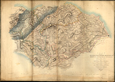
| Description: | Stirling to Aberdeen Railway. Sketch of country from Stirling to Aberdeen showing proposed line for canal or railway through Strathearn and Strathmore. Robert Stevenson, 1819 (marked copy). Engraving. | |
| Year: | 1819 | |
| County: | Aberdeen ; Clackmannan ; Edinburgh ; Fife ; Forfar ; Kincardine ; Kinross ; Perth ; Stirling ; West Lothian | |
| Subject: | Railway | |
| Colour: | Colour | |
| Media: | None | |
| Object: | Flat | |
| Physical: | Paper | |
| Size: | 290 x 705 mm | |
| Shelfmark: | Acc.10706, 458 | |
| Show location on map ? | ||
 | ||
| Zoom Into Map: | Click on the map to view in greater detail. | |
| Name: | Stevenson, Robert, 1772-1850 | |
| Description: | Stirling to Aberdeen Railway. Sketch of country from Stirling to Aberdeen showing proposed line for canal or railway through Strathearn and Strathmore. Robert Stevenson, 1819 (marked copy). | |
| Year: | 1819 | |
| County: | Aberdeen ; Clackmannan ; Edinburgh ; Fife ; Forfar ; Kincardine ; Kinross ; Perth ; Stirling ; West Lothian | |
| Subject: | Railway | |
| Colour: | Colour | |
| Media: | None | |
| Object: | Flat | |
| Physical: | Paper | |
| Size: | 275 x 760 mm | |
| Shelfmark: | Acc.10706, 459 | |
| Show location on map ? | ||
 | ||
| Zoom Into Map: | Click on the map to view in greater detail. | |
| Name: | Stevenson, Robert, 1772-1850 | |
| Description: | Montrose. Survey and sections of railway from Port of Montrose to Brechin | |
| Year: | 1819; 1825 | |
| Place: | Montrose | |
| County: | Forfar | |
| Subject: | Railway | |
| Inventory: | Drawing | |
| Colour: | Colour | |
| Media: | Hand coloured; Ink | |
| Object: | Flat | |
| Physical: | Paper/Linen/Cloth | |
| Size: | 765 mm x 1960 mm | |
| Shelfmark: | MS.5856, 36 - Mc | |
| Show location on map ? | ||
 | ||
| Zoom Into Map: | Click on the map to view in greater detail. | |
| Name: | Stevenson, Robert, 1772-1850 | |
| Description: | Penicuik. Part of parishes of Penicuik, Currie & Kirknewton showing two compensation reservoirs | |
| Year: | 1819 | |
| Place: | Penicuik | |
| County: | Edinburgh | |
| Subject: | Water Supply Works | |
| Inventory: | Drawing | |
| Colour: | Colour | |
| Media: | Graphite; Hand coloured; Ink | |
| Object: | Flat | |
| Physical: | Paper | |
| Size: | 530 mm x 850 mm | |
| Shelfmark: | MS.5859, 4 | |
| Show location on map ? | ||
| Name: | Stevenson, Robert, 1772-1850 | |
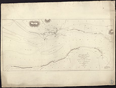
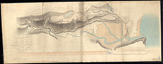
| Description: | Aberdeen Harbour. Plan of the Harbour and Basin of Aberdeen, with sections shewing the course of the River Dee and Spill Water Channel, Robert Stevenson, 1819. | |
| Year: | 1819 | |
| Place: | Aberdeen Harbour | |
| County: | Aberdeen | |
| Subject: | Harbour | |
| Colour: | Colour | |
| Media: | Linen/Cloth | |
| Object: | Folded | |
| Physical: | Paper | |
| Size: | 635 x 1600 mm | |
| Shelfmark: | Acc.10706, 671 | |
| Name: | Stevenson, Robert, 1772-1850 | |
| Description: | Kirk Kettle Ford. Survey and sections of improved lines of road at Cleugh leading ro Ford | |
| Year: | 1820 | |
| County: | Edinburgh | |
| Subject: | Road | |
| Inventory: | Drawing | |
| Colour: | Colour | |
| Media: | Graphite; Hand coloured; Ink | |
| Object: | Folded | |
| Physical: | Paper | |
| Size: | 530 mm x 1260 mm | |
| Shelfmark: | MS.5854, 47 | |
| Show location on map ? | ||
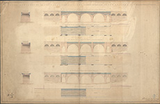
| Name: | Stevenson, Robert, 1772-1850 | |
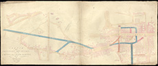
| Description: | Edinburgh, North Bridge. Plans and sections for widening & improving the North Bridge | |
| Year: | 1820 | |
| Place: | Edinburgh, North Bridge | |
| County: | Edinburgh | |
| Subject: | Bridge | |
| Inventory: | Series of 3 drawings | |
| Colour: | Colour | |
| Media: | Hand coloured; Ink | |
| Object: | Folded | |
| Physical: | Paper/Linen/Cloth | |
| Size: | 746 mm x 1147 mm | |
| Shelfmark: | MS.5849, 29 | |
 | ||
| Zoom Into Map: | Click on the map to view in greater detail. | |
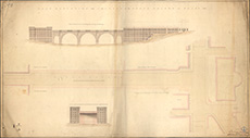
| Name: | Stevenson, Robert, 1772-1850 | |
| Description: | Edinburgh, North Bridge. Plans and sections for widening & improving the North Bridge | |
| Year: | 1820 | |
| Place: | Edinburgh, North Bridge | |
| County: | Edinburgh | |
| Subject: | Bridge | |
| Inventory: | Series of 3 drawings | |
| Colour: | Colour | |
| Media: | Hand coloured; Ink | |
| Object: | Folded | |
| Physical: | Paper/Linen/Cloth | |
| Size: | 710 mm x 1280 mm | |
| Shelfmark: | MS.5849, 30 | |
 | ||
| Zoom Into Map: | Click on the map to view in greater detail. | |
| Name: | Stevenson, Robert, 1772-1850 | |
| Description: | Tay, River. Wet Dock and line from Earn and Tay | |
| Year: | 1820 | |
| County: | Fife ; Perth | |
| Subject: | Harbour | |
| Inventory: | Drawing | |
| Colour: | Colour | |
| Media: | None | |
| Object: | Flat | |
| Physical: | Card | |
| Size: | 565 x 1850 mm | |
| Shelfmark: | MS.5863, 21 | |
| Show location on map ? | ||
| Name: | Stevenson, Robert, 1772-1850 | |
| Description: | Edinburgh, North Bridge. Plans and sections for widening & improving the North Bridge | |
| Year: | 1820 | |
| Place: | Edinburgh, North Bridge | |
| County: | Edinburgh | |
| Subject: | Bridge | |
| Inventory: | Series of 3 drawings | |
| Colour: | Colour | |
| Media: | Hand coloured; Ink | |
| Object: | Flat | |
| Physical: | Paper | |
| Size: | 295 mm x 680 mm | |
| Shelfmark: | MS.5849, 28 | |
| Show location on map ? | ||
 | ||
| Zoom Into Map: | Click on the map to view in greater detail. | |
| Name: | Stevenson, Robert, 1772-1850 | |
| Description: | Edinburgh, Princes Street. Retaining Wall for Mr Trotter's property proposed to be erected on Princes Street | |
| Year: | 1820 | |
| Place: | Edinburgh, Princes Street | |
| County: | Edinburgh | |
| Subject: | Road | |
| Inventory: | Series of 2 drawings | |
| Colour: | Colour | |
| Media: | Graphite; Hand coloured; Ink | |
| Object: | Flat | |
| Physical: | Paper | |
| Size: | 532 mm x 650 mm | |
| Shelfmark: | MS.5849, 48-49 | |
| Show location on map ? | ||
| Name: | Stevenson, Robert, 1772-1850 | |
| Description: | Almond Water. Bridge designs at Craigie Hall Mills | |
| Year: | 1820 | |
| Place: | Craigiehall | |
| County: | Edinburgh ; West Lothian | |
| Subject: | Bridge | |
| Inventory: | Drawing | |
| Colour: | Colour | |
| Media: | Hand coloured; Ink | |
| Object: | Flat | |
| Physical: | Paper | |
| Size: | 540 mm x 690 mm | |
| Shelfmark: | MS.5844, 69 | |
| Show location on map ? | ||
 | ||
| Zoom Into Map: | Click on the map to view in greater detail. | |
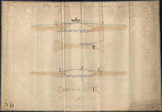
| Name: | Stevenson, Robert, 1772-1850 | |
| Description: | Almond Water. Plan & Elevation of Bridge | |
| Year: | 1820 | |
| Place: | Cramond Bridge | |
| County: | Edinburgh ; West Lothian | |
| Subject: | Bridge | |
| Inventory: | Drawing | |
| Colour: | Colour | |
| Media: | Graphite; Hand coloured; Ink | |
| Object: | Folded | |
| Physical: | Paper | |
| Size: | 850 mm x 1780 mm | |
| Shelfmark: | MS.5844, 70 | |
| Show location on map ? | ||
| Name: | Stevenson, Robert, 1772-1850 | |
| Description: | Almond Water. Elevation of Cramond Bridge | |
| Year: | 1820 | |
| Place: | Cramond Bridge | |
| County: | Edinburgh ; West Lothian | |
| Subject: | Bridge | |
| Inventory: | Series of five drawings | |
| Colour: | Colour | |
| Media: | Hand coloured; Ink | |
| Object: | Flat | |
| Physical: | Paper | |
| Size: | 225 mm x 360 mm | |
| Shelfmark: | MS.5844, 71 | |
| Show location on map ? | ||
 | ||
| Zoom Into Map: | Click on the map to view in greater detail. | |
| Name: | Stevenson, Robert, 1772-1850 | |
| Description: | Almond Water. Elevation of Cramond Bridge | |
| Year: | 1820 | |
| Place: | Cramond Bridge | |
| County: | Edinburgh ; West Lothian | |
| Subject: | Bridge | |
| Inventory: | Series of five drawings | |
| Colour: | Colour | |
| Media: | Graphite; Hand coloured; Ink | |
| Object: | Flat | |
| Physical: | Paper | |
| Size: | 275 mm x 370 mm | |
| Shelfmark: | MS.5844, 72 | |
| Show location on map ? | ||
 | ||
| Zoom Into Map: | Click on the map to view in greater detail. | |
| Name: | Stevenson, Robert, 1772-1850 | |
| Description: | Almond Water. Elevation of Cramond Bridge | |
| Year: | 1820 | |
| Place: | Cramond Bridge | |
| County: | Edinburgh ; West Lothian | |
| Subject: | Bridge | |
| Inventory: | Series of five drawings | |
| Colour: | B&W | |
| Media: | Ink | |
| Object: | Flat | |
| Physical: | Paper | |
| Size: | 257 mm x 225 mm | |
| Shelfmark: | MS.5844, 73 | |
| Show location on map ? | ||
 | ||
| Zoom Into Map: | Click on the map to view in greater detail. | |
| Name: | Stevenson, Robert, 1772-1850 | |
| Description: | Almond Water. Elevation of Cramond Bridge | |
| Year: | 1820 | |
| Place: | Cramond Bridge | |
| County: | Edinburgh ; West Lothian | |
| Subject: | Bridge | |
| Inventory: | Series of five drawings | |
| Colour: | B&W | |
| Media: | Ink | |
| Object: | Flat | |
| Physical: | Paper | |
| Size: | 195 mm x 260 mm | |
| Shelfmark: | MS.5844, 74 | |
| Show location on map ? | ||
 | ||
| Zoom Into Map: | Click on the map to view in greater detail. | |
| Name: | Stevenson, Robert, 1772-1850 | |
| Description: | Almond Water. Elevation of Cramond Bridge | |
| Year: | 1820 | |
| Place: | Cramond Bridge | |
| County: | Edinburgh ; West Lothian | |
| Subject: | Bridge | |
| Inventory: | Series of five drawings | |
| Colour: | Colour | |
| Media: | Hand coloured; Ink | |
| Object: | Flat | |
| Physical: | Paper | |
| Size: | 173 mm x 366 mm | |
| Shelfmark: | MS.5844, 75 | |
| Show location on map ? | ||
 | ||
| Zoom Into Map: | Click on the map to view in greater detail. | |
| Name: | Stevenson, Robert, 1772-1850 | |
| Description: | Crail. Harbour and sections showing proposed improvements | |
| Year: | 1821 | |
| Place: | Crail | |
| County: | Fife | |
| Subject: | Harbour | |
| Inventory: | Drawing | |
| Colour: | Colour | |
| Media: | Hand coloured; Ink | |
| Object: | Flat | |
| Size: | 725 mm x 640 mm | |
| Shelfmark: | MS.5846, 119 | |
| Show location on map ? | ||
| Name: | Stevenson, Robert, 1772-1850 | |
| Description: | Carriden. Part of sea coast showing proposed Wall and Footpath along seashore | |
| Year: | 1821 | |
| Place: | Carriden | |
| County: | West Lothian | |
| Subject: | Harbour | |
| Inventory: | Drawing | |
| Colour: | B&W | |
| Media: | Hand coloured; Ink | |
| Object: | Flat | |
| Physical: | Paper | |
| Size: | 580 mm x 1540 mm | |
| Shelfmark: | MS.5846, 34 | |
| Show location on map ? | ||
| Name: | Stevenson, Robert, 1772-1850 | |
| Description: | Fraserburgh. Harbour, with improvement on Inner Harbour | |
| Year: | 1821 | |
| Place: | Fraserburgh | |
| County: | Aberdeen | |
| Subject: | Harbour | |
| Inventory: | Drawing | |
| Colour: | Colour | |
| Media: | Graphite; Hand coloured; Ink | |
| Object: | Flat | |
| Physical: | Paper | |
| Size: | 535 mm x 640 mm | |
| Shelfmark: | MS.5850, 65 | |
| Show location on map ? | ||
 | ||
| Zoom Into Map: | Click on the map to view in greater detail. | |
| Name: | Stevenson, Robert, 1772-1850 | |
| Description: | Hopetoun. Sections of coast | |
| Year: | 1821 | |
| Place: | Hopetoun | |
| County: | West Lothian | |
| Subject: | Reference Material | |
| Inventory: | Drawing | |
| Colour: | Colour | |
| Media: | Hand coloured; Ink | |
| Object: | Folded | |
| Physical: | Paper | |
| Size: | 575 mm x 1385 mm | |
| Shelfmark: | MS.5852, 9 | |
| Show location on map ? | ||
| Name: | Stevenson, Robert, 1772-1850 | |
| Description: | Lord Melville's Monument. Section of the foundation-pit and underground work of the Melville Monument, Robert Stevenson, 1821. | |
| Year: | 1821 | |
| Place: | Edinburgh, Melville's Monument | |
| County: | Edinburgh | |
| Subject: | Building/Monument | |
| Colour: | Colour | |
| Media: | Linen/Cloth | |
| Object: | Flat | |
| Physical: | Paper | |
| Size: | 350 x 465 mm | |
| Shelfmark: | Acc.10706, 358 | |
| Show location on map ? | ||
 | ||
| Zoom Into Map: | Click on the map to view in greater detail. | |
| Name: | Stevenson, Robert, 1772-1850 | |
| Description: | Railways. Plan of proposed railway from the Coalfields of Mid-Lothian to the Rivers Tweed and Leeder, signed Robert Stevenson, 1821. (slightly different from 438). | |
| Year: | 1821 | |
| County: | Berwick ; East Lothian ; Edinburgh ; Peebles ; Roxburgh ; Selkirk | |
| Subject: | Railway | |
| Colour: | Colour | |
| Media: | Linen/Cloth | |
| Object: | Folded | |
| Physical: | Paper | |
| Size: | 1050 x 1500 mm | |
| Shelfmark: | Acc.10706, 439 | |
| Show location on map ? | ||
 | ||
| Zoom Into Map: | Click on the map to view in greater detail. | |
| Name: | Stevenson, Robert, 1772-1850 | |
| Description: | Kirkwall. Proposed harbour improvements | |
| Year: | 1821 | |
| Place: | Kirkwall | |
| County: | Orkney | |
| Subject: | Harbour | |
| Inventory: | Drawing | |
| Colour: | Colour | |
| Media: | Hand coloured; Ink | |
| Object: | Flat | |
| Physical: | Paper/Linen/Cloth | |
| Size: | 657 mm x 847 mm | |
| Shelfmark: | MS.5854, 50 | |
| Show location on map ? | ||
 | ||
| Zoom Into Map: | Click on the map to view in greater detail. | |
| Name: | Stevenson, Robert, 1772-1850 | |
| Description: | Kirkcaldy. Harbour, with proposed alterations to eastern, western and middle piers | |
| Year: | 1821 | |
| Place: | Kirkcaldy | |
| County: | Fife | |
| Subject: | Harbour | |
| Inventory: | Drawing | |
| Colour: | B&W | |
| Media: | Graphite; Ink | |
| Object: | Folded | |
| Physical: | Paper | |
| Size: | 755 mm x 695 mm | |
| Shelfmark: | MS.5854, 19 | |
| Show location on map ? | ||
| Name: | Stevenson, Robert, 1772-1850 | |
| Description: | Melville Castle. Plan and elevation of Bridge for the park | |
| Year: | 1821 | |
| Place: | Melville Castle | |
| County: | Edinburgh | |
| Subject: | Bridge | |
| Inventory: | Series of six drawings | |
| Colour: | Colour | |
| Media: | Graphite; Hand coloured; Ink | |
| Object: | Flat | |
| Physical: | Paper | |
| Size: | 540 mm x 660 mm | |
| Shelfmark: | MS.5856, 20 | |
| Show location on map ? | ||
| Name: | Stevenson, Robert, 1772-1850 | |
| Description: | Melville Castle. Plan and elevation of Bridge for the park | |
| Year: | 1821 | |
| Place: | Melville Castle | |
| County: | Edinburgh | |
| Subject: | Bridge | |
| Inventory: | Series of six drawings | |
| Colour: | B&W | |
| Media: | Graphite | |
| Object: | Flat | |
| Physical: | Paper | |
| Size: | 540 mm x 630 mm | |
| Shelfmark: | MS.5856, 21 | |
| Show location on map ? | ||
| Name: | Stevenson, Robert, 1772-1850 | |
| Description: | Melville Castle. Plan and elevation of Bridge for the park | |
| Year: | 1821 | |
| Place: | Melville Castle | |
| County: | Edinburgh | |
| Subject: | Bridge | |
| Inventory: | Series of six drawings | |
| Colour: | Colour | |
| Media: | Hand coloured; Ink | |
| Object: | Flat | |
| Physical: | Paper | |
| Size: | 490 mm x 600 mm | |
| Shelfmark: | MS.5856, 22 | |
| Show location on map ? | ||
| Name: | Stevenson, Robert, 1772-1850 | |
| Description: | Melville Castle. Plan and elevation of Bridge for the park | |
| Year: | 1821 | |
| Place: | Melville Castle | |
| County: | Edinburgh | |
| Subject: | Bridge | |
| Inventory: | Series of six drawings | |
| Colour: | Colour | |
| Media: | Hand coloured; Ink | |
| Object: | Flat | |
| Physical: | Paper | |
| Size: | 505 mm x 670 mm | |
| Shelfmark: | MS.5856, 23 | |
| Show location on map ? | ||
| Name: | Stevenson, Robert, 1772-1850 | |
| Description: | Melville Castle. Plan and elevation of Bridge for the park | |
| Year: | 1821 | |
| Place: | Melville Castle | |
| County: | Edinburgh | |
| Subject: | Bridge | |
| Inventory: | Series of six drawings | |
| Colour: | B&W | |
| Media: | Graphite | |
| Object: | Flat | |
| Physical: | Paper | |
| Size: | 330 mm x 540 mm | |
| Shelfmark: | MS.5856, 24 | |
| Show location on map ? | ||
 | ||
| Zoom Into Map: | Click on the map to view in greater detail. | |
| Name: | Stevenson, Robert, 1772-1850 | |
| Description: | Melville Castle. Plan and elevation of Bridge for the park | |
| Year: | 1821 | |
| Place: | Melville Castle | |
| County: | Edinburgh | |
| Subject: | Bridge | |
| Inventory: | Series of six drawings | |
| Colour: | B&W | |
| Media: | Graphite | |
| Object: | Flat | |
| Physical: | Paper | |
| Size: | 280 mm x 465 mm | |
| Shelfmark: | MS.5856, 25 | |
| Show location on map ? | ||
| Name: | Stevenson, Robert, 1772-1850 | |
| Description: | Melville Castle. Sketches of proposed bridge | |
| Year: | 1821 | |
| Place: | Melville Castle | |
| County: | Edinburgh | |
| Subject: | Bridge | |
| Inventory: | Drawing | |
| Colour: | Colour | |
| Media: | Hand coloured; Ink | |
| Object: | Flat | |
| Physical: | Paper | |
| Size: | 780 mm x 730 mm | |
| Shelfmark: | MS.5856, 26 | |
| Show location on map ? | ||
| Name: | Stevenson, Robert, 1772-1850 | |
| Description: | Midlothian Coalfield to Rivers Tweed and Leeder proposed railway. Reduced Plan of part of the shires of Edinburgh, Haddington, Berwick, Roxburgh & Selkirk shewing proposed lines of Railway from the Coalfield of Midlothian to the Rivers Tweed & Leeder, Rob | |
| Year: | 1821 | |
| County: | Berwick ; East Lothian ; Edinburgh ; Peebles ; Roxburgh ; Selkirk | |
| Subject: | Railway | |
| Colour: | Colour | |
| Media: | None | |
| Object: | Folded | |
| Physical: | Paper | |
| Size: | 300 x 630 mm | |
| Shelfmark: | Acc.10706, 694 | |
| Name: | Stevenson, Robert, 1772-1850 | |
| Description: | Melville Castle. Sketches for a Bridge of Maleable Iron over the River Esk in the Park of Melville Castle, Robert Stevenson, 1822 | |
| Year: | 1822 | |
| Place: | Melville Castle | |
| County: | Edinburgh | |
| Subject: | Bridge | |
| Colour: | Colour | |
| Media: | Linen/Cloth | |
| Object: | Folded | |
| Physical: | Paper | |
| Size: | 660 x 960 mm | |
| Shelfmark: | Acc.10706, 692 | |
 | ||
| Zoom Into Map: | Click on the map to view in greater detail. | |
| Name: | Stevenson, Robert, 1772-1850 | |
| Description: | Linlithgow. Longitudinal cross section of main street | |
| Year: | 1822 | |
| Place: | Linlithgow | |
| County: | West Lothian | |
| Subject: | Road | |
| Inventory: | Drawing | |
| Colour: | Colour | |
| Media: | Graphite; Hand coloured; Ink | |
| Object: | Folded | |
| Physical: | Paper | |
| Size: | 785 mm x 2060 mm | |
| Shelfmark: | MS.5855, 47 | |
| Show location on map ? | ||
| Name: | Stevenson, Robert, 1772-1850 | |
| Description: | Portobello. Village, lands and harbour | |
| Year: | 1822 | |
| Place: | Portobello | |
| County: | Edinburgh | |
| Subject: | Harbour | |
| Inventory: | Drawing | |
| Colour: | Colour | |
| Media: | None | |
| Object: | Folded | |
| Physical: | Card | |
| Size: | 820 x 1050 mm | |
| Shelfmark: | MS.5859, 122 | |
| Show location on map ? | ||
| Name: | Stevenson, Robert, 1772-1850 | |
| Description: | Edinburgh, Trinity. Proposes sea wallon north side of lands of Trinity Lodge | |
| Year: | 1822 | |
| Place: | Edinburgh, Trinity | |
| County: | Edinburgh | |
| Subject: | Harbour | |
| Inventory: | Series of 2 drawings | |
| Colour: | B&W | |
| Media: | Graphite | |
| Object: | Flat | |
| Physical: | Paper | |
| Size: | 680 mm x 987 mm | |
| Shelfmark: | MS.5849, 81 | |
 | ||
| Zoom Into Map: | Click on the map to view in greater detail. | |
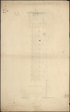
| Name: | Stevenson, Robert, 1772-1850 | |
| Description: | Lord Melville's Monument. Elevation of Lord Melville's Monument showing the scaffolding employed in it's erection. R Stevenson, 1822. | |
| Year: | 1822 | |
| Place: | Edinburgh, Melville's Monument | |
| County: | Edinburgh | |
| Subject: | Building/Monument | |
| Colour: | B&W | |
| Object: | Flat | |
| Physical: | Paper | |
| Size: | 990 x 615 mm | |
| Shelfmark: | Acc.10706, 356 | |
| Show location on map ? | ||
 | ||
| Zoom Into Map: | Click on the map to view in greater detail. | |
| Name: | Stevenson, Robert, 1772-1850 | |
| Description: | Drains. Sketch plan of Broughton Road and the neighbouring streets showing the direction of the drains. (referred to in a report by Robert Stevenson), 1822. | |
| Year: | 1822 | |
| Place: | Edinburgh, Broughton Road | |
| County: | Edinburgh | |
| Subject: | Water Supply Works | |
| Colour: | Colour | |
| Media: | None | |
| Object: | Flat | |
| Physical: | Paper | |
| Size: | 621 x 500 mm | |
| Shelfmark: | Acc.10706, 287 | |
| Show location on map ? | ||
| Name: | Stevenson, Robert, 1772-1850 | |
| Description: | Edinburgh, Trinity. Proposes sea wallon north side of lands of Trinity Lodge | |
| Year: | 1822 | |
| Place: | Edinburgh, Trinity | |
| County: | Edinburgh | |
| Subject: | Harbour | |
| Inventory: | Series of 2 drawings | |
| Colour: | Colour | |
| Media: | Hand coloured; Ink | |
| Object: | Flat | |
| Physical: | Paper | |
| Size: | 655 mm x 1005 mm | |
| Shelfmark: | MS.5849, 80 | |
| Show location on map ? | ||
 | ||
| Zoom Into Map: | Click on the map to view in greater detail. | |
| Name: | Stevenson, Robert, 1772-1850 | |
| Description: | Fisherrow. Survey of harbour with sections of proposed improvements | |
| Year: | 1822 | |
| Place: | Fisherrow | |
| County: | Edinburgh | |
| Subject: | Harbour | |
| Inventory: | Drawing | |
| Object: | Flat | |
| Shelfmark: | MS.5850, 15 | |
| Show location on map ? | ||
| Name: | Stevenson, Robert, 1772-1850 | |
| Description: | Caledonian Canal. Lock | |
| Year: | 1822 | |
| County: | Inverness | |
| Subject: | Canal | |
| Inventory: | Tracing | |
| Colour: | Colour | |
| Media: | Hand coloured; Ink | |
| Object: | Flat | |
| Physical: | Paper | |
| Size: | 520 mm x 620 mm | |
| Shelfmark: | MS.5846, 15 | |
 | ||
| Zoom Into Map: | Click on the map to view in greater detail. | |
| Name: | Stevenson, Robert, 1772-1850 | |
| Description: | Don, River. Bridge and ravine below present bridge | |
| Year: | 1823 | |
| County: | Aberdeen | |
| Subject: | Bridge | |
| Inventory: | Drawing | |
| Colour: | B&W | |
| Media: | Graphite; Ink | |
| Object: | Flat | |
| Physical: | Paper | |
| Size: | 595 mm x 1000 mm | |
| Shelfmark: | MS.5847, 12 | |
| Show location on map ? | ||
| Name: | Stevenson, Robert, 1772-1850 ; Stevenson, Alan, 1807-1865 ; Stevenson, David, 1815-1886 | |
| Description: | Annan. Bridge | |
| Year: | 1824 | |
| Place: | Annan | |
| County: | Dumfries | |
| Subject: | Bridge | |
| Inventory: | Drawing | |
| Colour: | B&W | |
| Media: | Graphite; Ink | |
| Object: | Folded | |
| Physical: | Paper | |
| Size: | 543 mm x 1440 mm | |
| Shelfmark: | MS.5844, 89 | |
| Show location on map ? | ||
| Name: | Stevenson, Robert, 1772-1850 ; Stevenson, Alan, 1807-1865 ; Stevenson, David, 1815-1886 | |
| Description: | Annan. Bridge, sections | |
| Year: | 1824 | |
| Place: | Annan | |
| County: | Dumfries | |
| Subject: | Bridge | |
| Inventory: | Series of three drawings | |
| Colour: | B&W | |
| Media: | Ink | |
| Object: | Flat | |
| Physical: | Paper | |
| Size: | 280 mm x 437 mm | |
| Shelfmark: | MS.5844, 90 | |
| Show location on map ? | ||
 | ||
| Zoom Into Map: | Click on the map to view in greater detail. | |
| Name: | Stevenson, Robert, 1772-1850 ; Stevenson, Alan, 1807-1865 ; Stevenson, David, 1815-1886 | |
| Description: | Annan. Bridge, sections | |
| Year: | 1824 | |
| Place: | Annan | |
| County: | Dumfries | |
| Subject: | Bridge | |
| Inventory: | Series of three drawings | |
| Colour: | B&W | |
| Media: | Graphite; Ink | |
| Object: | Flat | |
| Physical: | Paper | |
| Size: | 381 mm x 540 mm | |
| Shelfmark: | MS.5844, 91 | |
| Show location on map ? | ||
 | ||
| Zoom Into Map: | Click on the map to view in greater detail. | |
| Name: | Stevenson, Robert, 1772-1850 ; Stevenson, Alan, 1807-1865 ; Stevenson, David, 1815-1886 | |
| Description: | Annan. Bridge, sections | |
| Year: | 1824 | |
| Place: | Annan | |
| County: | Dumfries | |
| Subject: | Bridge | |
| Inventory: | Series of three drawings | |
| Colour: | Colour | |
| Media: | Graphite; Hand coloured; Ink | |
| Object: | Flat | |
| Physical: | Paper | |
| Size: | 536 mm x 643 mm | |
| Shelfmark: | MS.5844, 92 | |
| Show location on map ? | ||
 | ||
| Zoom Into Map: | Click on the map to view in greater detail. | |
| Name: | Stevenson, Robert, 1772-1850 | |
| Description: | Annan. Sections of Town and River | |
| Year: | 1824 | |
| Place: | Annan | |
| County: | Dumfries | |
| Subject: | River | |
| Inventory: | Drawing | |
| Colour: | Colour | |
| Media: | Graphite; Hand coloured; Ink | |
| Object: | Flat | |
| Physical: | Paper | |
| Size: | 845 mm x 1292 mm | |
| Shelfmark: | MS.5844, 93 | |
| Show location on map ? | ||
 | ||
| Zoom Into Map: | Click on the map to view in greater detail. | |
| Name: | Stevenson, Robert, 1772-1850 | |
| Description: | Edinburgh. Plan and section of aqueduct & reservoir | |
| Year: | 1824 | |
| Place: | Edinburgh | |
| County: | Edinburgh | |
| Subject: | Water Supply Works | |
| Inventory: | Drawing | |
| Colour: | Colour | |
| Media: | Hand coloured; Ink | |
| Object: | Flat | |
| Physical: | Paper/Linen/Cloth | |
| Size: | 680 mm x 1620 mm | |
| Shelfmark: | MS.5849, 98 | |
| Show location on map ? | ||
 | ||
| Zoom Into Map: | Click on the map to view in greater detail. | |
| Name: | Stevenson, Robert, 1772-1850 | |
| Description: | Edinburgh, Leith, Water of. Position of reservoirs for supply of mills | |
| Year: | 1824 | |
| County: | Edinburgh ; Peebles | |
| Subject: | Water Supply Works | |
| Inventory: | Drawing | |
| Colour: | Colour | |
| Media: | Hand coloured; Ink | |
| Object: | Folded | |
| Physical: | Paper/Linen/Cloth | |
| Size: | 760 mm x 1310 mm | |
| Shelfmark: | MS.5848, 96 | |
| Show location on map ? | ||
 | ||
| Zoom Into Map: | Click on the map to view in greater detail. | |
| Name: | Stevenson, Robert, 1772-1850 | |
| Description: | Kincardine. Design of Dock for repair of ships | |
| Year: | 1824 | |
| Place: | Kincardine | |
| County: | Fife | |
| Subject: | Harbour | |
| Inventory: | Drawing | |
| Colour: | Colour | |
| Media: | Graphite; Hand coloured; Ink | |
| Object: | Flat | |
| Physical: | Paper | |
| Size: | 543 mm x 972 mm | |
| Shelfmark: | MS.5854, 12 | |
| Show location on map ? | ||
| Name: | Stevenson, Robert, 1772-1850 | |
| Description: | Roads and Bridges - Edinburgh. Sketch of a new proposed access from the Cross to the Grass Market. Robert Stevenson, 1824. | |
| Year: | 1824 | |
| Place: | Edinburgh, Grassmarket | |
| County: | Edinburgh | |
| Subject: | Road | |
| Colour: | Colour | |
| Media: | Linen/Cloth | |
| Object: | Flat | |
| Physical: | Paper | |
| Size: | 525 x 1300 mm | |
| Shelfmark: | Acc.10706, 466 | |
| Show location on map ? | ||
 | ||
| Zoom Into Map: | Click on the map to view in greater detail. | |
| Name: | Stevenson, Robert, 1772-1850 | |
| Description: | Stonehaven. Survey of harbour with proposed improvements | |
| Year: | 1824 | |
| Place: | Stonehaven | |
| County: | Kincardine | |
| Subject: | Harbour | |
| Inventory: | Series of 2 prints by Jas. Wyness | |
| Colour: | B&W | |
| Media: | None | |
| Object: | Flat | |
| Physical: | Card | |
| Size: | 860 x 665 mm | |
| Shelfmark: | MS.5862, 115 | |
| Show location on map ? | ||
| Name: | Stevenson, Robert, 1772-1850 | |
| Description: | Stonehaven. Survey of harbour with proposed improvements | |
| Year: | 1824 | |
| Place: | Stonehaven | |
| County: | Kincardine | |
| Subject: | Harbour | |
| Inventory: | Series of 2 prints by Jas. Wyness | |
| Colour: | Colour | |
| Media: | None | |
| Object: | Flat | |
| Physical: | Card | |
| Size: | 850 x 660 mm | |
| Shelfmark: | MS.5862, 116 | |
| Show location on map ? | ||
| Name: | Stevenson, Robert, 1772-1850 | |
| Description: | Stonehaven. Harbour and improvements | |
| Year: | 1824 | |
| Place: | Stonehaven | |
| County: | Kincardine | |
| Subject: | Harbour | |
| Inventory: | Drawing | |
| Colour: | Colour | |
| Media: | None | |
| Object: | Folded | |
| Physical: | Card | |
| Size: | 730 x 980 mm | |
| Shelfmark: | MS.5862, 117 | |
| Show location on map ? | ||
| Name: | Stevenson, Robert, 1772-1850 | |
| Description: | Peterhead. North harbour and proposed new quay | |
| Year: | 1824 | |
| Place: | Peterhead | |
| County: | Aberdeen | |
| Subject: | Harbour | |
| Inventory: | Drawing | |
| Colour: | Colour | |
| Media: | None | |
| Object: | Flat | |
| Physical: | Paper | |
| Size: | 530 x 656 mm | |
| Shelfmark: | MS.5859, 50 | |
| Show location on map ? | ||
 | ||
| Zoom Into Map: | Click on the map to view in greater detail. | |
| Name: | Stevenson, Robert, 1772-1850 ; Steedman, John | |
| Description: | Montrose. Railway from Montrose to Brechin, with proposed extensions | |
| Year: | 1825 | |
| Place: | Montrose | |
| County: | Forfar | |
| Subject: | Railway | |
| Inventory: | Drawing | |
| Colour: | Colour | |
| Media: | Hand coloured; Printed | |
| Object: | Folded | |
| Physical: | Paper/Linen/Cloth | |
| Size: | 7700 mm x 1940 mm | |
| Shelfmark: | MS.5856, 37 - Mc | |
| Show location on map ? | ||
 | ||
| Zoom Into Map: | Click on the map to view in greater detail. | |
| Name: | Stevenson, Robert, 1772-1850 | |
| Description: | Stonehaven. Proposed southern pier | |
| Year: | 1825 | |
| Place: | Stonehaven | |
| County: | Kincardine | |
| Subject: | Harbour | |
| Inventory: | Series of 2 drawings | |
| Colour: | Colour | |
| Media: | None | |
| Object: | Folded | |
| Physical: | Card | |
| Size: | 700 x 1130 mm | |
| Shelfmark: | MS.5862, 118 | |
| Show location on map ? | ||
| Name: | Stevenson, Robert, 1772-1850 | |
| Description: | Stonehaven. Proposed southern pier | |
| Year: | 1825 | |
| Place: | Stonehaven | |
| County: | Kincardine | |
| Subject: | Harbour | |
| Inventory: | Series of 2 drawings | |
| Colour: | Colour | |
| Media: | Linen/Cloth | |
| Object: | Folded | |
| Physical: | Paper | |
| Size: | 1140 x 775 mm | |
| Shelfmark: | MS.5862, 119 | |
| Show location on map ? | ||
 | ||
| Zoom Into Map: | Click on the map to view in greater detail. | |
| Name: | Stevenson, Robert, 1772-1850 | |
| Description: | East Lothian Railway. Plan from Cairnie to Haddington and Dunbar. Robert Stevenson, 1825. | |
| Year: | 1825 | |
| County: | East Lothian ; Edinburgh | |
| Subject: | Railway | |
| Colour: | Colour | |
| Media: | Linen/Cloth | |
| Object: | Folded | |
| Physical: | Paper | |
| Size: | 610 x 2300 mm | |
| Shelfmark: | Acc.10706, 406 | |
| Show location on map ? | ||
| Name: | Stevenson, Robert, 1772-1850 | |
| Description: | Figgat Burn. Plan and sections | |
| Year: | 1825 | |
| County: | Edinburgh | |
| Subject: | River | |
| Inventory: | Drawing | |
| Colour: | Colour | |
| Media: | Hand coloured; Ink | |
| Object: | Folded | |
| Physical: | Paper | |
| Size: | 850 mm x 1050 mm | |
| Shelfmark: | MS.5850, 4 | |
| Show location on map ? | ||
| Name: | Stevenson, Robert, 1772-1850 | |
| Description: | Arbroath. Harbour extension | |
| Year: | 1825 | |
| Place: | Arbroath | |
| County: | Forfar | |
| Subject: | Harbour | |
| Inventory: | Drawing | |
| Colour: | Colour | |
| Media: | Graphite; Hand coloured; Ink | |
| Object: | Folded | |
| Physical: | Paper | |
| Size: | 765 mm x 1449 mm | |
| Shelfmark: | MS.5844, 115 | |
| Show location on map ? | ||
| Name: | Maxton, Robert ; Stevenson, Robert, 1772-1850 ; Bald, Robert, 1776-1861 | |
| Description: | Alloa. Harbour and Ferry, for forming Sea Loch and Basin | |
| Year: | 1825 | |
| Place: | Alloa | |
| County: | Clackmannan | |
| Subject: | Harbour | |
| Inventory: | Drawing | |
| Colour: | Colour | |
| Media: | Hand coloured; Ink | |
| Object: | Flat | |
| Physical: | Paper | |
| Size: | 680 mm x 1012 mm | |
| Shelfmark: | MS.5844, 59 | |
| Show location on map ? | ||
| Name: | Maxton, Robert ; Stevenson, Robert, 1772-1850 ; Bald, Robert, 1776-1862 | |
| Description: | Alloa. Harbour and Ferry, for forming Sea Loch and Basin | |
| Year: | 1825 | |
| Place: | Alloa | |
| County: | Clackmannan | |
| Subject: | Harbour | |
| Inventory: | Drawing - Larger scale | |
| Colour: | Colour | |
| Media: | Hand coloured; Ink | |
| Object: | Folded | |
| Physical: | Paper/Linen/Cloth | |
| Size: | 975 mm x 1600 mm | |
| Shelfmark: | MS.5844, 60 | |
| Show location on map ? | ||
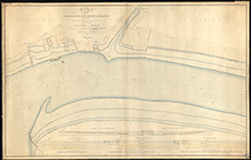 | ||
| Zoom Into Map: | Click on the map to view in greater detail. | |
| Name: | Stevenson, Robert, 1772-1850 | |
| Description: | Edinburgh: Granton. Small Ox Craig: Survey of Morrison's Haven | |
| Year: | 1825 | |
| Place: | Granton | |
| County: | Edinburgh | |
| Subject: | Reference Material | |
| Inventory: | Drawing | |
| Colour: | Colour | |
| Media: | Hand coloured; Ink | |
| Object: | Folded | |
| Physical: | Paper | |
| Size: | 670 mm x 1170 mm | |
| Shelfmark: | MS.5848, 45 | |
| Show location on map ? | ||
| Name: | Stevenson, Robert, 1772-1850 | |
| Description: | Alloa. Harbour showing proposed Docks, Swivel Bridge and Loch Gates | |
| Year: | 1826 | |
| Place: | Alloa | |
| County: | Clackmannan | |
| Subject: | Harbour | |
| Inventory: | Drawing | |
| Colour: | Colour | |
| Media: | Hand coloured; Ink | |
| Object: | Folded | |
| Physical: | Paper/Linen/Cloth | |
| Size: | 730 mm x 1262 mm | |
| Shelfmark: | MS.5844, 61 | |
| Show location on map ? | ||
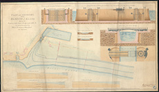 | ||
| Zoom Into Map: | Click on the map to view in greater detail. | |
| Name: | Stevenson, Robert, 1772-1850 | |
| Description: | Denny. Surrounding lands and roads | |
| Year: | 1826 | |
| Place: | Denny | |
| County: | Stirling | |
| Subject: | Road | |
| Inventory: | Drawing | |
| Colour: | Colour | |
| Media: | Graphite; Hand coloured; Ink | |
| Object: | Folded | |
| Physical: | Paper | |
| Size: | 605 mm x 1270 mm | |
| Shelfmark: | MS.5847, 8 | |
| Show location on map ? | ||
| Name: | Stevenson, Robert, 1772-1850 | |
| Description: | Roads and Bridges - Stirling Bridge. Design for Stirling Bridge signed Robert Stevenson, 1826. | |
| Year: | 1826 | |
| Place: | Stirling | |
| County: | Stirling | |
| Subject: | Bridge | |
| Colour: | Colour | |
| Media: | Linen/Cloth | |
| Object: | Folded | |
| Physical: | Paper | |
| Size: | 725 x 1280 mm | |
| Shelfmark: | Acc.10706, 506 | |
| Show location on map ? | ||
 | ||
| Zoom Into Map: | Click on the map to view in greater detail. | |
| Name: | Stevenson, Robert, 1772-1850 | |
| Description: | Stirling. Part of town | |
| Year: | 1826 | |
| Place: | Stirling | |
| County: | Stirling | |
| Subject: | Reference Material | |
| Inventory: | Drawing | |
| Colour: | Colour | |
| Media: | None | |
| Object: | Folded | |
| Physical: | Card | |
| Size: | 735 x 1500 mm | |
| Shelfmark: | MS.5862, 108 | |
| Show location on map ? | ||
| Name: | Stevenson, Robert, 1772-1850 | |
| Description: | Stirling. Proposed alternations on road from Stirling to Crieff | |
| Year: | 1826 | |
| Place: | Stirling | |
| County: | Stirling | |
| Subject: | Road | |
| Inventory: | Series of 2 drawings | |
| Colour: | Colour | |
| Media: | Linen/Cloth | |
| Object: | Folded | |
| Physical: | Paper | |
| Size: | 725 x 1800 mm | |
| Shelfmark: | MS.5862, 109 | |
| Show location on map ? | ||
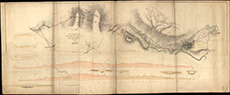 | ||
| Zoom Into Map: | Click on the map to view in greater detail. | |
| Name: | Stevenson, Robert, 1772-1850 | |
| Description: | Stirling. Proposed alternations on road from Stirling to Crieff | |
| Year: | 1826 | |
| Place: | Stirling | |
| County: | Stirling | |
| Subject: | Road | |
| Inventory: | Series of 2 drawings | |
| Colour: | Colour | |
| Media: | None | |
| Object: | Folded | |
| Physical: | Card | |
| Size: | 920 x 1600 mm | |
| Shelfmark: | MS.5862, 110 | |
| Show location on map ? | ||
| Name: | Stevenson, Robert, 1772-1850 | |
| Description: | Peterhead. Harbour and improvements | |
| Year: | 1826 | |
| Place: | Peterhead | |
| County: | Aberdeen | |
| Subject: | Harbour | |
| Inventory: | Series of 2 prints | |
| Colour: | Colour | |
| Media: | None | |
| Object: | Flat | |
| Physical: | Paper | |
| Size: | 340 x 460 mm | |
| Shelfmark: | MS.5859, 51 | |
| Show location on map ? | ||
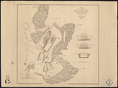 | ||
| Zoom Into Map: | Click on the map to view in greater detail. | |
| Name: | Stevenson, Robert, 1772-1850 | |
| Description: | Peterhead. Harbour and improvements | |
| Year: | 1826 | |
| Place: | Peterhead | |
| County: | Aberdeen | |
| Subject: | Harbour | |
| Inventory: | Series of 2 prints | |
| Colour: | B&W | |
| Media: | None | |
| Object: | Flat | |
| Physical: | Paper | |
| Size: | 340 x 400 mm | |
| Shelfmark: | MS.5859, 52 | |
| Show location on map ? | ||
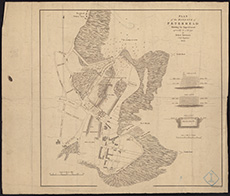 | ||
| Zoom Into Map: | Click on the map to view in greater detail. | |
| Name: | Stevenson, Robert, 1772-1850 | |
| Description: | Peterhead. Improvement of harbour | |
| Year: | 1826 | |
| Place: | Peterhead | |
| County: | Aberdeen | |
| Subject: | Harbour | |
| Inventory: | Drawing | |
| Colour: | Colour | |
| Media: | Linen/Cloth | |
| Object: | Folded | |
| Physical: | Paper | |
| Size: | 1200 x 1000 mm | |
| Shelfmark: | MS.5859, 54 | |
| Show location on map ? | ||
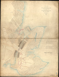 | ||
| Zoom Into Map: | Click on the map to view in greater detail. | |
| Name: | Stevenson, Robert, 1772-1850 | |
| Description: | Peterhead. Nerth harbour and ground which may be acquired eastward from the graving dock | |
| Year: | 1826 | |
| Place: | Peterhead | |
| County: | Aberdeen | |
| Subject: | Harbour | |
| Inventory: | Drawing | |
| Colour: | Colour | |
| Media: | None | |
| Object: | Flat | |
| Physical: | Card | |
| Size: | 650 x 960 mm | |
| Shelfmark: | MS.5859, 55 | |
| Show location on map ? | ||
| Name: | Stevenson, Robert, 1772-1850 | |
| Description: | Perth. Bridge, as proposed to be altered by Cast Iron footpaths | |
| Year: | 1827 | |
| Place: | Perth | |
| County: | Perth | |
| Subject: | Bridge | |
| Inventory: | Drawing | |
| Colour: | Colour | |
| Media: | Graphite; Hand coloured; Ink | |
| Object: | Folded | |
| Physical: | Paper/Linen/Cloth | |
| Size: | 520 mm x 1250 mm | |
| Shelfmark: | MS.5859, 10 | |
| Show location on map ? | ||
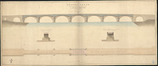 | ||
| Zoom Into Map: | Click on the map to view in greater detail. | |
| Name: | Stevenson, Robert, 1772-1850 | |
| Description: | Edinburgh, Leith. Water of. Course of River in reference to Clermont Cresc. and Clerks Mill Bleachfield | |
| Year: | 1827 | |
| County: | Edinburgh | |
| Subject: | River | |
| Inventory: | Drawing. 2 Copies | |
| Colour: | Colour | |
| Media: | Hand coloured; Ink | |
| Object: | Flat | |
| Physical: | Card | |
| Size: | 500 mm x 670 mm | |
| Shelfmark: | MS.5848, 98 - 99 | |
| Show location on map ? | ||
| Name: | Stevenson, Robert, 1772-1850 ; Lamb, James | |
| Description: | Dunwan. Plan of reservoir | |
| Year: | 1827 | |
| Place: | Dunwan | |
| County: | Renfrew | |
| Subject: | Water Supply Works | |
| Inventory: | Drawing | |
| Colour: | Colour | |
| Media: | Hand coloured; Ink | |
| Object: | Folded | |
| Physical: | Paper/Linen/Cloth | |
| Size: | 768 mm x 1050 mm | |
| Shelfmark: | MS.5847, 109 | |
| Show location on map ? | ||
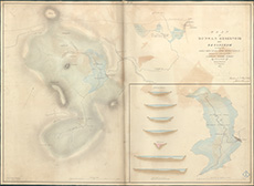 | ||
| Zoom Into Map: | Click on the map to view in greater detail. | |
| Name: | Stevenson, Robert, 1772-1850 | |
| Description: | Edinburgh, Prestonfield. Survey in reference to tunnel works through the lands of Sir R.K.Dick | |
| Year: | 1828 | |
| Place: | Edinburgh, Prestonfield | |
| County: | Edinburgh | |
| Subject: | Reference Material | |
| Inventory: | Drawing | |
| Colour: | Colour | |
| Media: | Hand coloured; Ink | |
| Object: | Flat | |
| Physical: | Paper | |
| Size: | 323 mm x 204 mm | |
| Shelfmark: | MS.5849, 47 | |
| Show location on map ? | ||
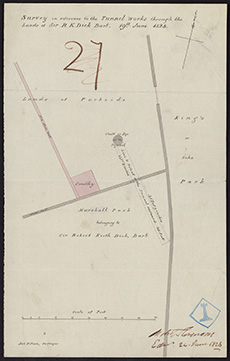 | ||
| Zoom Into Map: | Click on the map to view in greater detail. | |
| Name: | Stevenson, Robert, 1772-1850 | |
| Description: | Glasgow. Plan & section of reservior near Drygate Street | |
| Year: | 1828 | |
| Place: | Glasgow | |
| County: | Lanark | |
| Subject: | Water Supply Works | |
| Inventory: | Drawing | |
| Colour: | Colour | |
| Media: | Hand coloured; Ink | |
| Object: | Folded | |
| Physical: | Paper | |
| Size: | 990 mm x 990 mm | |
| Shelfmark: | MS.5851, 21 | |
| Show location on map ? | ||
| Name: | Stevenson, Robert, 1772-1850 | |
| Description: | Glasgow. Design for bridge between Saltmarket St & Hutcheson | |
| Year: | 1828 | |
| Place: | Glasgow | |
| County: | Lanark | |
| Subject: | Bridge | |
| Inventory: | Tracing | |
| Colour: | Colour | |
| Media: | Hand coloured; Ink | |
| Object: | Folded | |
| Physical: | Transparent paper/Paper | |
| Size: | 675 mm x 1220 mm | |
| Shelfmark: | MS.5851, 22 | |
| Show location on map ? | ||
| Name: | Stevenson, Robert, 1772-1850 | |
| Description: | Glasgow. Plan & section showing situation of Hutchison Bridge | |
| Year: | 1828 | |
| Place: | Glasgow | |
| County: | Lanark | |
| Subject: | Bridge | |
| Inventory: | Drawing | |
| Colour: | Colour | |
| Media: | Hand coloured; Ink | |
| Object: | Folded | |
| Physical: | Paper | |
| Size: | 850 mm x 1143 mm | |
| Shelfmark: | MS.5851, 23 | |
| Show location on map ? | ||
| Name: | Stevenson, Robert, 1772-1850 | |
| Description: | Glasgow. Design for bridge between Saltmarket & Hutcheson | |
| Year: | 1828 | |
| Place: | Glasgow | |
| County: | Lanark | |
| Subject: | Bridge | |
| Inventory: | Drawing | |
| Colour: | Colour | |
| Media: | Hand coloured; Ink | |
| Object: | Folded | |
| Physical: | Paper | |
| Size: | 790 mm x 1160 mm | |
| Shelfmark: | MS.5851, 24 | |
| Show location on map ? | ||
| Name: | Stevenson, Robert, 1772-1850 | |
| Description: | Beacons - Gantocks.. Designs for Beacons proposed to be erected on the rocks of Gantocks & Captain's Bridges, 1828. Robert Stevenson. | |
| Year: | 1828 | |
| Place: | Gantocks. | |
| Subject: | Lighthouse | |
| Colour: | Colour | |
| Media: | Linen/Cloth | |
| Object: | Folded | |
| Physical: | Paper | |
| Size: | 770 x 1050 mm | |
| Shelfmark: | Acc.10706, 612 | |
| Show location on map ? | ||
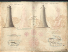 | ||
| Zoom Into Map: | Click on the map to view in greater detail. | |
| Name: | Stevenson, Robert, 1772-1850 | |
| Description: | Beacons - Gantocks.. Design fora Beacon to be erected on the Gantock Rocks, 1829. Robert Stevenson. | |
| Year: | 1829 | |
| Place: | Gantocks. | |
| Subject: | Lighthouse | |
| Colour: | Colour | |
| Media: | None | |
| Object: | Folded | |
| Physical: | Paper | |
| Size: | 660 x 980 mm | |
| Shelfmark: | Acc.10706, 613 | |
| Show location on map ? | ||
| Name: | Stevenson, Robert, 1772-1850 | |
| Description: | Stirling. Copy of design for bridge | |
| Year: | 1829 | |
| Place: | Stirling | |
| County: | Stirling | |
| Subject: | Bridge | |
| Inventory: | Drawing | |
| Colour: | Colour | |
| Media: | Linen/Cloth | |
| Object: | Folded | |
| Physical: | Card | |
| Size: | 775 x 1070 mm | |
| Shelfmark: | MS.5862, 111 | |
| Show location on map ? | ||
| Name: | Stevenson, Robert, 1772-1850 | |
| Description: | Esk, River, North. Survey of part of the river | |
| Year: | 1829 | |
| County: | Edinburgh | |
| Subject: | River | |
| Inventory: | Drawing | |
| Colour: | Colour | |
| Media: | Hand coloured; Ink | |
| Object: | Flat | |
| Physical: | Paper | |
| Size: | 280 mm x 450 mm | |
| Shelfmark: | MS.5849, 120 | |
| Show location on map ? | ||
| Name: | Stevenson, Robert, 1772-1850 | |
| Description: | Cockenzie. Village showing improvement of West Pier | |
| Year: | 1829 | |
| Place: | Cockenzie | |
| County: | East Lothian | |
| Subject: | Harbour | |
| Inventory: | Drawing | |
| Colour: | Colour | |
| Media: | Graphite; Hand coloured; Ink | |
| Object: | Flat | |
| Physical: | Paper | |
| Size: | 683 mm x 1120 mm | |
| Shelfmark: | MS.5846, 83 | |
| Show location on map ? | ||
| Name: | Stevenson, Robert, 1772-1850 | |
| Description: | Anstruther. Harbour Improvements | |
| Year: | 1829 | |
| Place: | Anstruther | |
| County: | Fife | |
| Subject: | Harbour | |
| Inventory: | Drawing | |
| Colour: | Colour | |
| Media: | Graphite; Hand coloured; Ink | |
| Object: | Flat | |
| Physical: | Paper/Linen/Cloth | |
| Size: | 620 mm x 963 mm | |
| Shelfmark: | MS.5844, 95 | |
| Show location on map ? | ||
| Name: | Telford, Thomas, 1757-1834 ; Stevenson, Robert, 1772-1850 | |
| Description: | Aberdeen. North Pier Head of Harbour | |
| Year: | 1830 | |
| Place: | Aberdeen | |
| County: | Aberdeen | |
| Subject: | Harbour | |
| Inventory: | Drawing | |
| Colour: | B&W | |
| Media: | Ink | |
| Object: | Flat | |
| Physical: | Paper | |
| Size: | 450 mm x 840 mm | |
| Shelfmark: | MS.5844, 17 | |
| Show location on map ? | ||
 | ||
| Zoom Into Map: | Click on the map to view in greater detail. | |
| Name: | Telford, Thomas, 1757-1834 ; Stevenson, Robert, 1772-1850 | |
| Description: | Aberdeen. North Pier Head of Harbour | |
| Year: | 1830 | |
| Place: | Aberdeen | |
| County: | Aberdeen | |
| Subject: | Harbour | |
| Inventory: | Drawing | |
| Colour: | B&W | |
| Media: | Ink | |
| Object: | Folded | |
| Physical: | Paper | |
| Size: | 720 mm x 650 mm | |
| Shelfmark: | MS.5844, 18 | |
| Show location on map ? | ||
| Name: | Telford, Thomas, 1757-1834 ; Stevenson, Robert, 1772-1850 | |
| Description: | Aberdeen. North Pier Head of Harbour | |
| Year: | 1830 | |
| Place: | Aberdeen | |
| County: | Aberdeen | |
| Subject: | Harbour | |
| Inventory: | Drawing | |
| Colour: | B&W | |
| Media: | Ink | |
| Object: | Folded | |
| Physical: | Paper | |
| Size: | 720 mm x 640 mm | |
| Shelfmark: | MS.5844, 19 | |
| Show location on map ? | ||
| Name: | Stevenson, Robert, 1772-1850 | |
| Description: | Dornoch. Design of wooden bridge for Podahurich at Dornoch Meikle Ferry | |
| Year: | 1830 | |
| Place: | Dornoch | |
| County: | Sutherland | |
| Subject: | Bridge | |
| Inventory: | Drawing | |
| Colour: | Colour | |
| Media: | Hand coloured; Ink | |
| Object: | Folded | |
| Physical: | Paper | |
| Size: | 670 mm x 2960 mm | |
| Shelfmark: | MS.5847, 22 | |
| Show location on map ? | ||
| Name: | Stevenson, Robert, 1772-1850 | |
| Description: | Dornoch Firth. Survey showing present ferry and others | |
| Year: | 1830 | |
| County: | Sutherland | |
| Subject: | Reference Material | |
| Inventory: | Drawing | |
| Colour: | Colour | |
| Media: | Hand coloured; Ink | |
| Object: | Folded | |
| Physical: | Paper | |
| Size: | 1620 mm x 1300 mm | |
| Shelfmark: | MS.5847, 22a | |
| Show location on map ? | ||
| Name: | Stevenson, Robert, 1772-1850 | |
| Description: | Ayr. Harbour with proposed extension of piers and excavation in interior of harbour | |
| Year: | 1830 | |
| Place: | Ayr | |
| County: | Ayr | |
| Subject: | Harbour | |
| Inventory: | Drawings | |
| Colour: | Colour | |
| Media: | Graphite; Hand coloured; Ink | |
| Physical: | Paper | |
| Size: | 982 mm x 2020 mm | |
| Shelfmark: | MS.5844, 148 | |
| Show location on map ? | ||
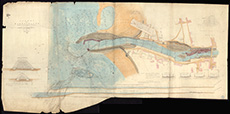 | ||
| Zoom Into Map: | Click on the map to view in greater detail. | |
| Name: | Stevenson, Robert, 1772-1850 | |
| Description: | Dornoch Firth. Map of Firth | |
| Year: | 1831 | |
| County: | Sutherland | |
| Subject: | Reference Material | |
| Inventory: | Drawing and two prints | |
| Colour: | Colour | |
| Media: | Hand coloured; Ink | |
| Object: | Flat | |
| Physical: | Paper | |
| Size: | 353 mm x 615 mm | |
| Shelfmark: | MS.5847, 23 | |
| Show location on map ? | ||
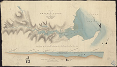 | ||
| Zoom Into Map: | Click on the map to view in greater detail. | |
| Name: | Stevenson, Robert, 1772-1850 | |
| Description: | Dornoch Firth. Map of Firth | |
| Year: | 1831 | |
| County: | Sutherland | |
| Subject: | Reference Material | |
| Inventory: | Drawing and two prints | |
| Colour: | Colour | |
| Media: | Hand coloured; Printed | |
| Object: | Flat | |
| Physical: | Paper | |
| Size: | 440 mm x 552 mm | |
| Shelfmark: | MS.5847, 24 | |
| Show location on map ? | ||
| Name: | Stevenson, Robert, 1772-1850 | |
| Description: | Dornoch Firth. Map of Firth | |
| Year: | 1831 | |
| County: | Sutherland | |
| Subject: | Reference Material | |
| Inventory: | Drawing and two prints | |
| Colour: | Colour | |
| Media: | Hand coloured; Printed | |
| Object: | Flat | |
| Physical: | Paper | |
| Size: | 440 mm x 560 mm | |
| Shelfmark: | MS.5847, 25 | |
| Show location on map ? | ||
| Name: | Stevenson, Robert, 1772-1850 | |
| Description: | Edinburgh, Leith, Water of. Sections at St.Marks Place | |
| Year: | 1831 | |
| County: | Edinburgh | |
| Subject: | River | |
| Inventory: | Drawing | |
| Colour: | Colour | |
| Media: | Graphite; Hand coloured; Ink | |
| Object: | Flat | |
| Physical: | Paper | |
| Size: | 595 mm x 812 mm | |
| Shelfmark: | MS.5848, 100 | |
| Show location on map ? | ||
| Name: | Stevenson, Robert, 1772-1850 | |
| Description: | Edinburgh: Howard Place. New road to Warriston | |
| Year: | 1831 | |
| Place: | Edinburgh, Howard Place | |
| County: | Edinburgh | |
| Subject: | Road | |
| Inventory: | Drawing | |
| Colour: | Colour | |
| Media: | Hand coloured; Ink | |
| Object: | Flat | |
| Physical: | Paper | |
| Size: | 664 mm x 990 mm | |
| Shelfmark: | MS.5848, 62 | |
| Show location on map ? | ||
| Name: | Stevenson, Robert, 1772-1850 | |
| Description: | Glasgow. Survey of part of city and section of Clyde with proposed bridge near Broomielaw | |
| Year: | 1831 | |
| Place: | Glasgow | |
| County: | Lanark | |
| Subject: | Bridge | |
| Inventory: | Drawing | |
| Colour: | Colour | |
| Media: | Hand coloured; Ink | |
| Object: | Folded | |
| Physical: | Paper | |
| Size: | 670 mm x 990 mm | |
| Shelfmark: | MS.5851, 32 | |
| Show location on map ? | ||
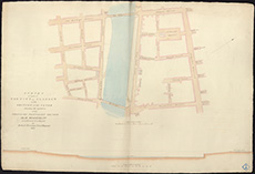 | ||
| Zoom Into Map: | Click on the map to view in greater detail. | |
| Name: | Stevenson, Robert, 1772-1850 | |
| Description: | Glasgow. Survey of two railway lines Paisley Canal Aqueduct to Rutherglen | |
| Year: | 1831 | |
| Place: | Glasgow | |
| County: | Lanark | |
| Subject: | Railway | |
| Inventory: | Drawing | |
| Colour: | Colour | |
| Media: | Hand coloured; Ink | |
| Object: | Folded | |
| Physical: | Paper/Linen/Cloth | |
| Size: | 1035 mm x 1450 mm | |
| Shelfmark: | MS.5851, 33 - Mc | |
| Show location on map ? | ||
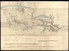 | ||
| Zoom Into Map: | Click on the map to view in greater detail. | |
| Name: | Stevenson, Robert, 1772-1850 | |
| Description: | Glasgow. Survey and sections of above | |
| Year: | 1831 | |
| Place: | Glasgow | |
| County: | Lanark | |
| Subject: | Railway | |
| Inventory: | Drawing | |
| Colour: | Colour | |
| Media: | Hand coloured; Ink | |
| Object: | Folded | |
| Physical: | Paper/Linen/Cloth | |
| Size: | 1140 mm x 1510 mm | |
| Shelfmark: | MS.5851, 34 | |
| Show location on map ? | ||
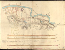 | ||
| Zoom Into Map: | Click on the map to view in greater detail. | |
| Name: | Stevenson, Robert, 1772-1850 | |
| Description: | Montrose. Design for safety chain for Bridge of Montrose | |
| Year: | 1831 | |
| Place: | Montrose | |
| County: | Forfar | |
| Subject: | Machinery | |
| Inventory: | Drawing | |
| Colour: | Colour | |
| Media: | Hand coloured; Ink | |
| Object: | Folded | |
| Physical: | Card | |
| Size: | 650 mm x 2500 mm | |
| Shelfmark: | MS.5856, 39 | |
| Show location on map ? | ||
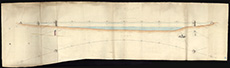 | ||
| Zoom Into Map: | Click on the map to view in greater detail. | |
| Name: | Stevenson, Robert, 1772-1850 | |
| Description: | Montrose. Bridge and harbour showing proposed safety chain | |
| Year: | 1831 | |
| Place: | Montrose | |
| County: | Forfar | |
| Subject: | Bridge | |
| Inventory: | Drawing | |
| Colour: | Colour | |
| Media: | Hand coloured; Ink | |
| Object: | Flat | |
| Physical: | Paper | |
| Size: | 660 mm x 800 mm | |
| Shelfmark: | MS.5856, 40 | |
| Show location on map ? | ||
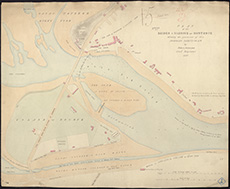 | ||
| Zoom Into Map: | Click on the map to view in greater detail. | |
| Name: | Stevenson, Robert, 1772-1850 | |
| Description: | Railways. Sections from the River Clyde toward the south showing railway lines etc. Report by Robert Stevenson, 1831. | |
| Year: | 1831 | |
| County: | Lanark | |
| Subject: | Railway | |
| Colour: | Colour | |
| Media: | None | |
| Object: | Flat | |
| Physical: | Card | |
| Size: | 600 x 530 mm | |
| Shelfmark: | Acc.10706, 401 | |
| Show location on map ? | ||
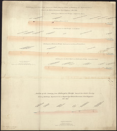 | ||
| Zoom Into Map: | Click on the map to view in greater detail. | |
| Name: | Stevenson, Robert, 1772-1850 | |
| Description: | Hutcheson Bridge, Glasgow. Elevation of Hutcheson Bridge, Glasgow, designed by Robert Stevenson Esq., in 1832 | |
| Year: | 1832 | |
| Place: | Hutcheson Bridge | |
| County: | Lanark | |
| Subject: | Bridge | |
| Colour: | B&W | |
| Media: | None | |
| Object: | Folded | |
| Physical: | Paper | |
| Size: | 240 x 960 mm | |
| Shelfmark: | Acc.10706, 688 | |
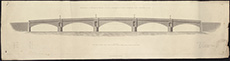 | ||
| Zoom Into Map: | Click on the map to view in greater detail. | |
| Name: | Stevenson, Robert, 1772-1850 | |
| Description: | Roads and Bridges - Glasgow. Hutcheson Bridge, Glasgow: Elevation of Hutcheson Bridge, Glasgow, designed by Robert Stevenson Esq. Completed in 1832. | |
| Year: | 1832 | |
| Place: | Glasgow | |
| County: | Lanark | |
| Subject: | Bridge | |
| Colour: | B&W | |
| Media: | None | |
| Object: | Flat | |
| Physical: | Paper | |
| Size: | 255 x 965 mm | |
| Shelfmark: | Acc.10706, 476 | |
| Show location on map ? | ||
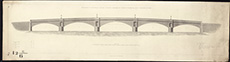 | ||
| Zoom Into Map: | Click on the map to view in greater detail. | |
| Name: | Stevenson, Robert, 1772-1850 | |
| Description: | Roads and Bridges - Glasgow. Hutcheson Bridge, Glasgow: Cross section of south approach to Hutcheson Bridge. Robert Stevenson, 1832. | |
| Year: | 1832 | |
| Place: | Glasgow | |
| County: | Lanark | |
| Subject: | Bridge | |
| Colour: | B&W | |
| Media: | None | |
| Object: | Flat | |
| Physical: | Paper | |
| Size: | 240 x 640 mm | |
| Shelfmark: | Acc.10706, 481 | |
| Show location on map ? | ||
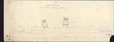 | ||
| Zoom Into Map: | Click on the map to view in greater detail. | |
| Name: | Stevenson, Robert, 1772-1850 | |
| Description: | Almond Water. Sections of river and Boathouse Bridge | |
| Year: | 1832-4 | |
| Place: | Boathouse Bridge | |
| County: | Edinburgh | |
| Subject: | Bridge | |
| Inventory: | Series of six drawings | |
| Colour: | B&W | |
| Media: | Ink | |
| Object: | Flat | |
| Physical: | Paper | |
| Size: | 675 mm x 1010 mm | |
| Shelfmark: | MS.5844, 77 | |
| Show location on map ? | ||
| Name: | Stevenson, Robert, 1772-1850 | |
| Description: | Almond Water. Sections of river and Boathouse Bridge | |
| Year: | 1832-4 | |
| Place: | Boathouse Bridge | |
| County: | Edinburgh | |
| Subject: | Bridge | |
| Inventory: | Series of six drawings | |
| Colour: | Colour | |
| Media: | Graphite; Hand coloured; Printed | |
| Object: | Flat | |
| Physical: | Paper | |
| Size: | 665 mm x 980 mm | |
| Shelfmark: | MS.5844, 78 | |
| Show location on map ? | ||
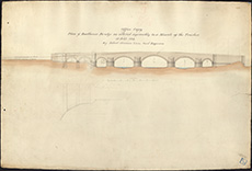 | ||
| Zoom Into Map: | Click on the map to view in greater detail. | |
| Name: | Stevenson, Robert, 1772-1850 | |
| Description: | Almond Water. Sections of river and Boathouse Bridge | |
| Year: | 1832-4 | |
| Place: | Boathouse Bridge | |
| County: | Edinburgh | |
| Subject: | Bridge | |
| Inventory: | Series of six drawings | |
| Colour: | Colour | |
| Media: | Graphite; Hand coloured; Ink | |
| Object: | Flat | |
| Physical: | Paper | |
| Size: | 820 mm x 990 mm | |
| Shelfmark: | MS.5844, 79 | |
| Show location on map ? | ||
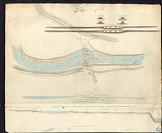 | ||
| Zoom Into Map: | Click on the map to view in greater detail. | |
| Name: | Stevenson, Robert, 1772-1850 | |
| Description: | Almond Water. Sections of river and Boathouse Bridge | |
| Year: | 1832-4 | |
| Place: | Boathouse Bridge | |
| County: | Edinburgh | |
| Subject: | Bridge | |
| Inventory: | Series of six drawings | |
| Colour: | Colour | |
| Media: | Hand coloured; Ink | |
| Object: | Flat | |
| Physical: | Paper | |
| Size: | 228 mm x 945 mm | |
| Shelfmark: | MS.5844, 80 | |
| Show location on map ? | ||
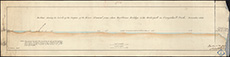 | ||
| Zoom Into Map: | Click on the map to view in greater detail. | |
| Name: | Stevenson, Robert, 1772-1850 | |
| Description: | Almond Water. Sections of river and Boathouse Bridge | |
| Year: | 1832-4 | |
| Place: | Boathouse Bridge | |
| County: | Edinburgh | |
| Subject: | Bridge | |
| Inventory: | Series of six drawings | |
| Colour: | Colour | |
| Media: | Hand coloured; Ink | |
| Object: | Flat | |
| Physical: | Paper/Linen/Cloth | |
| Size: | 640 mm x 970 mm | |
| Shelfmark: | MS.5844, 81 | |
| Show location on map ? | ||
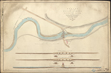 | ||
| Zoom Into Map: | Click on the map to view in greater detail. | |
| Name: | Stevenson, Robert, 1772-1850 | |
| Description: | Almond Water. Sections of river and Boathouse Bridge | |
| Year: | 1832-4 | |
| Place: | Boathouse Bridge | |
| County: | Edinburgh | |
| Subject: | Bridge | |
| Inventory: | Series of six drawings | |
| Colour: | Colour | |
| Media: | Graphite; Hand coloured; Ink | |
| Object: | Flat | |
| Physical: | Paper | |
| Size: | 441 mm x 678 mm | |
| Shelfmark: | MS.5844, 82 | |
| Show location on map ? | ||
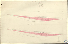 | ||
| Zoom Into Map: | Click on the map to view in greater detail. | |
| Name: | Stevenson, Robert, 1772-1850 | |
| Description: | Duncow. Plan of burn from Glencarrick distillery to Duncow Mills | |
| Year: | 1833 | |
| Place: | Duncow | |
| County: | Dumfries | |
| Subject: | River | |
| Inventory: | Drawing | |
| Colour: | Colour | |
| Media: | Graphite; Hand coloured; Ink | |
| Object: | Flat | |
| Physical: | Paper | |
| Size: | 795 mm x 560 mm | |
| Shelfmark: | MS.5847, 64 | |
| Show location on map ? | ||
| Name: | Stevenson, Robert, 1772-1850 | |
| Description: | Cockenzie. Harbour, East Pier and excavation of area | |
| Year: | 1833 and 1841 | |
| Place: | Cockenzie | |
| County: | East Lothian | |
| Subject: | Harbour | |
| Inventory: | Series of five drawings | |
| Colour: | B&W | |
| Media: | Printed | |
| Object: | Flat | |
| Size: | 250 mm x 406 mm | |
| Shelfmark: | MS.5846, 78 | |
| Show location on map ? | ||
| Name: | Stevenson, Robert, 1772-1850 | |
| Description: | Glasgow. Plan, sections & specifications for wooden bridge over Clyde | |
| Year: | 1833-4 | |
| Place: | Glasgow | |
| County: | Lanark | |
| Subject: | Bridge | |
| Inventory: | Series of 12 drawings | |
| Colour: | B&W | |
| Media: | Hand coloured; Ink | |
| Object: | Flat | |
| Physical: | Paper | |
| Size: | 257 mm x 600 mm | |
| Shelfmark: | MS.5851, 40 | |
| Show location on map ? | ||
| Name: | Stevenson, Robert, 1772-1850 | |
| Description: | Glasgow. Plan, sections & specifications for wooden bridge over Clyde | |
| Year: | 1833-4 | |
| Place: | Glasgow | |
| County: | Lanark | |
| Subject: | Bridge | |
| Inventory: | Series of 12 drawings | |
| Colour: | B&W | |
| Media: | Ink | |
| Object: | Flat | |
| Physical: | Paper | |
| Size: | 187 mm x 229 mm | |
| Shelfmark: | MS.5851, 41 | |
| Show location on map ? | ||
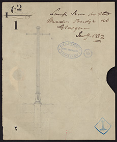 | ||
| Zoom Into Map: | Click on the map to view in greater detail. | |
| Name: | Stevenson, Robert, 1772-1850 | |
| Description: | Glasgow. Plan, sections & specifications for wooden bridge over Clyde | |
| Year: | 1833-4 | |
| Place: | Glasgow | |
| County: | Lanark | |
| Subject: | Bridge | |
| Inventory: | Series of 12 drawings | |
| Colour: | B&W | |
| Media: | Printed | |
| Object: | Flat | |
| Physical: | Paper | |
| Size: | 408 mm x 325 mm | |
| Shelfmark: | MS.5851, 42 | |
| Show location on map ? | ||
 | ||
| Zoom Into Map: | Click on the map to view in greater detail. | |
| Name: | Stevenson, Robert, 1772-1850 | |
| Description: | Glasgow. Plan, sections & specifications for wooden bridge over Clyde | |
| Year: | 1833-4 | |
| Place: | Glasgow | |
| County: | Lanark | |
| Subject: | Bridge | |
| Inventory: | Series of 12 drawings | |
| Colour: | B&W | |
| Media: | Ink | |
| Object: | Flat | |
| Physical: | Paper | |
| Size: | 404 mm x 325 mm | |
| Shelfmark: | MS.5851, 43 | |
| Show location on map ? | ||
 | ||
| Zoom Into Map: | Click on the map to view in greater detail. | |
| Name: | Stevenson, Robert, 1772-1850 | |
| Description: | Glasgow. Plan, sections & specifications for wooden bridge over Clyde | |
| Year: | 1833-4 | |
| Place: | Glasgow | |
| County: | Lanark | |
| Subject: | Bridge | |
| Inventory: | Series of 12 drawings | |
| Colour: | B&W | |
| Media: | Graphite; Hand coloured; Ink | |
| Object: | Flat | |
| Physical: | Paper | |
| Size: | 257 mm x 595 mm | |
| Shelfmark: | MS.5851, 44 | |
| Show location on map ? | ||
| Name: | Stevenson, Robert, 1772-1850 | |
| Description: | Glasgow. Plan, sections & specifications for wooden bridge over Clyde | |
| Year: | 1833-4 | |
| Place: | Glasgow | |
| County: | Lanark | |
| Subject: | Bridge | |
| Inventory: | Series of 12 drawings | |
| Colour: | Colour | |
| Media: | Hand coloured; Ink | |
| Object: | Flat | |
| Physical: | Paper | |
| Size: | 520 mm x 266 mm | |
| Shelfmark: | MS.5851, 45 | |
| Show location on map ? | ||
 | ||
| Zoom Into Map: | Click on the map to view in greater detail. | |
| Name: | Stevenson, Robert, 1772-1850 | |
| Description: | Glasgow. Plan, sections & specifications for wooden bridge over Clyde | |
| Year: | 1833-4 | |
| Place: | Glasgow | |
| County: | Lanark | |
| Subject: | Bridge | |
| Inventory: | Series of 12 drawings | |
| Colour: | Colour | |
| Media: | Hand coloured; Ink | |
| Object: | Flat | |
| Physical: | Paper | |
| Size: | 475 mm x 282 mm | |
| Shelfmark: | MS.5851, 46 | |
| Show location on map ? | ||
| Name: | Stevenson, Robert, 1772-1850 | |
| Description: | Glasgow. Plan, sections & specifications for wooden bridge over Clyde | |
| Year: | 1833-4 | |
| Place: | Glasgow | |
| County: | Lanark | |
| Subject: | Bridge | |
| Inventory: | Series of 12 drawings | |
| Colour: | Colour | |
| Media: | Hand coloured; Ink | |
| Object: | Flat | |
| Physical: | Paper | |
| Size: | 500 mm x 670 mm | |
| Shelfmark: | MS.5851, 47 | |
| Show location on map ? | ||
| Name: | Stevenson, Robert, 1772-1850 | |
| Description: | Glasgow. Plan, sections & specifications for wooden bridge over Clyde | |
| Year: | 1833-4 | |
| Place: | Glasgow | |
| County: | Lanark | |
| Subject: | Bridge | |
| Inventory: | Series of 12 drawings | |
| Colour: | Colour | |
| Media: | Hand coloured; Ink | |
| Object: | Flat | |
| Physical: | Paper | |
| Size: | 505 mm x 665 mm | |
| Shelfmark: | MS.5851, 48 | |
| Show location on map ? | ||
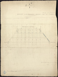 | ||
| Zoom Into Map: | Click on the map to view in greater detail. | |
| Name: | Stevenson, Robert, 1772-1850 | |
| Description: | Glasgow. Plan, sections & specifications for wooden bridge over Clyde | |
| Year: | 1833-4 | |
| Place: | Glasgow | |
| County: | Lanark | |
| Subject: | Bridge | |
| Inventory: | Series of 12 drawings | |
| Colour: | Colour | |
| Media: | Hand coloured; Ink | |
| Object: | Flat | |
| Physical: | Paper | |
| Size: | 663 mm x 707 mm | |
| Shelfmark: | MS.5851, 49 | |
| Show location on map ? | ||
| Name: | Stevenson, Robert, 1772-1850 | |
| Description: | Glasgow. Plan, sections & specifications for wooden bridge over Clyde | |
| Year: | 1833-4 | |
| Place: | Glasgow | |
| County: | Lanark | |
| Subject: | Bridge | |
| Inventory: | Series of 12 drawings | |
| Colour: | Colour | |
| Media: | Hand coloured; Ink | |
| Object: | Flat | |
| Physical: | Paper | |
| Size: | 850 mm x 603 mm | |
| Shelfmark: | MS.5851, 50 | |
| Show location on map ? | ||
| Name: | Stevenson, Robert, 1772-1850 | |
| Description: | Glasgow. Plan, sections & specifications for wooden bridge over Clyde | |
| Year: | 1833-4 | |
| Place: | Glasgow | |
| County: | Lanark | |
| Subject: | Bridge | |
| Inventory: | Series of 12 drawings | |
| Colour: | Colour | |
| Media: | Ink | |
| Object: | Flat | |
| Physical: | Paper | |
| Size: | 670 mm x 813 mm | |
| Shelfmark: | MS.5851, 51 | |
| Show location on map ? | ||
| Name: | Stevenson, Robert, 1772-1850 | |
| Description: | Edinburgh: Hillside. Lands showing City Boundary and Parish of South Leith | |
| Year: | 1833 | |
| Place: | Edinburgh, Hillside | |
| County: | Edinburgh | |
| Subject: | Reference Material | |
| Inventory: | Drawing | |
| Colour: | Colour | |
| Media: | Hand coloured; Ink | |
| Object: | Flat | |
| Physical: | Paper | |
| Size: | 548 mm x 752 mm | |
| Shelfmark: | MS.5848, 60 | |
| Show location on map ? | ||
| Name: | Stevenson, Robert, 1772-1850 | |
| Description: | Edinburgh: Hillside. James Grant's feu, showing boundary of South Leith | |
| Year: | 1833 | |
| Place: | Edinburgh, Hillside | |
| County: | Edinburgh | |
| Subject: | Reference Material | |
| Inventory: | Drawing | |
| Colour: | Colour | |
| Media: | Graphite; Hand coloured; Ink | |
| Object: | Flat | |
| Physical: | Paper | |
| Size: | 496 mm x 728 mm | |
| Shelfmark: | MS.5848, 61 | |
| Show location on map ? | ||
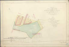 | ||
| Zoom Into Map: | Click on the map to view in greater detail. | |
| Name: | Stevenson, Robert, 1772-1850 | |
| Description: | Harbours - Minch. Sketch of The Minch relative to the conveyance of the Stornoway Mail referred to in a report by Robert Stevenson, Civil Engineer, 1833 | |
| Year: | 1833 | |
| Place: | Minch | |
| Subject: | Harbour | |
| Colour: | Colour | |
| Media: | None | |
| Object: | Flat | |
| Physical: | Card | |
| Shelfmark: | Acc.10706, 297 | |
| Show location on map ? | ||
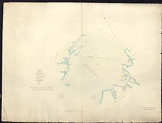 | ||
| Zoom Into Map: | Click on the map to view in greater detail. | |
| Name: | Stevenson, Robert, 1772-1850 ; Stevenson, Alan, 1807-1865 | |
| Description: | Tay, River. Survey from Perth to Invergowie | |
| Year: | 1833 | |
| County: | Fife ; Forfar ; Perth | |
| Subject: | River | |
| Inventory: | 6 prints by WH Lizars | |
| Colour: | Colour | |
| Media: | None | |
| Object: | Flat | |
| Physical: | Paper | |
| Size: | 550 x 900 mm | |
| Shelfmark: | MS.5863, 24 | |
| Show location on map ? | ||
| Name: | Stevenson, Robert, 1772-1850 ; Stevenson, Alan, 1807-1865 | |
| Description: | Tay, River. Survey from Perth to Invergowie | |
| Year: | 1833 | |
| County: | Fife ; Forfar ; Perth | |
| Subject: | River | |
| Inventory: | 6 prints by WH Lizars | |
| Colour: | Colour | |
| Media: | None | |
| Object: | Flat | |
| Physical: | Paper | |
| Size: | 460 x 860 mm | |
| Shelfmark: | MS.5863, 25 | |
| Show location on map ? | ||
| Name: | Stevenson, Robert, 1772-1850 ; Stevenson, Alan, 1807-1865 | |
| Description: | Tay, River. Survey from Perth to Invergowie | |
| Year: | 1833 | |
| County: | Fife ; Forfar ; Perth | |
| Subject: | River | |
| Inventory: | 6 prints by WH Lizars | |
| Colour: | Colour | |
| Media: | None | |
| Object: | Flat | |
| Physical: | Card | |
| Size: | 510 x 890 mm | |
| Shelfmark: | MS.5863, 26 | |
| Show location on map ? | ||
| Name: | Stevenson, Robert, 1772-1850 ; Stevenson, Alan, 1807-1865 | |
| Description: | Tay, River. Survey from Perth to Invergowie | |
| Year: | 1833 | |
| County: | Fife ; Forfar ; Perth | |
| Subject: | River | |
| Inventory: | 6 prints by WH Lizars | |
| Colour: | B&W | |
| Media: | None | |
| Object: | Flat | |
| Physical: | Card | |
| Size: | 500 x 880 mm | |
| Shelfmark: | MS.5863, 27 | |
| Show location on map ? | ||
| Name: | Stevenson, Robert, 1772-1850 ; Stevenson, Alan, 1807-1865 | |
| Description: | Tay, River. Survey from Perth to Invergowie | |
| Year: | 1833 | |
| County: | Fife ; Forfar ; Perth | |
| Subject: | River | |
| Inventory: | 6 prints by WH Lizars | |
| Colour: | Colour | |
| Media: | None | |
| Object: | Flat | |
| Physical: | Paper | |
| Size: | 545 x 900 mm | |
| Shelfmark: | MS.5863, 28 | |
| Show location on map ? | ||
| Name: | Stevenson, Robert, 1772-1850 ; Stevenson, Alan, 1807-1865 | |
| Description: | Tay, River. Survey from Perth to Invergowie | |
| Year: | 1833 | |
| County: | Fife ; Forfar ; Perth | |
| Subject: | River | |
| Inventory: | 6 prints by WH Lizars | |
| Colour: | Colour | |
| Media: | None | |
| Object: | Flat | |
| Physical: | Card | |
| Size: | 465 x 870 mm | |
| Shelfmark: | MS.5863, 29 | |
| Show location on map ? | ||
| Name: | Stevenson, Robert, 1772-1850 ; Ritson, James ; Stevenson, Alan, 1807-1865 | |
| Description: | Lossiemouth. Harbour and improvements | |
| Year: | 1833 | |
| Place: | Lossiemouth | |
| County: | Elgin | |
| Subject: | Harbour | |
| Inventory: | Drawing | |
| Colour: | Colour | |
| Media: | Graphite; Hand coloured; Ink | |
| Object: | Flat | |
| Physical: | Paper | |
| Size: | 670 mm x 1000 mm | |
| Shelfmark: | MS.5855, 63 | |
| Show location on map ? | ||
| Name: | Stevenson, Robert, 1772-1850 ; Stevenson, Alan, 1807-1865 | |
| Description: | Perth. Proposed Wet Dock | |
| Year: | 1833 | |
| Place: | Perth | |
| County: | Perth | |
| Subject: | Harbour | |
| Inventory: | Drawing. Series of two | |
| Colour: | Colour | |
| Media: | Hand coloured; Ink | |
| Object: | Folded | |
| Physical: | Paper/Linen/Cloth | |
| Size: | 770 mm x 1800 mm | |
| Shelfmark: | MS.5859, 13 | |
| Show location on map ? | ||
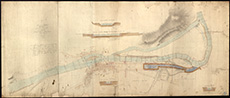 | ||
| Zoom Into Map: | Click on the map to view in greater detail. | |
| Name: | Stevenson, Robert, 1772-1850 ; Stevenson, Alan, 1807-1865 | |
| Description: | Perth. Proposed Wet Dock | |
| Year: | 1833 | |
| Place: | Perth | |
| County: | Perth | |
| Subject: | Harbour | |
| Inventory: | Drawing. Series of two | |
| Colour: | Colour | |
| Media: | Hand coloured; Ink | |
| Object: | Folded | |
| Physical: | Paper/Linen/Cloth | |
| Size: | 750 mm x 1300 mm | |
| Shelfmark: | MS.5859, 14 | |
| Show location on map ? | ||
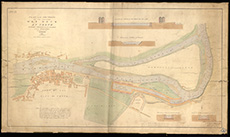 | ||
| Zoom Into Map: | Click on the map to view in greater detail. | |
| Name: | Stevenson, Robert, 1772-1850 ; Stevenson, Alan, 1807-1865 | |
| Description: | Perth. Plan and section of Tide Harbour | |
| Year: | 1834 | |
| Place: | Perth | |
| County: | Perth | |
| Subject: | Harbour | |
| Inventory: | Drawing | |
| Colour: | Colour | |
| Media: | Hand coloured; Ink | |
| Object: | Folded | |
| Physical: | Paper/Linen/Cloth | |
| Size: | 530 mm x 920 mm | |
| Shelfmark: | MS.5859, 17 | |
| Show location on map ? | ||
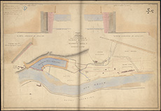 | ||
| Zoom Into Map: | Click on the map to view in greater detail. | |
| Name: | Stevenson, Robert, 1772-1850 ; Stevenson, Alan, 1807-1865 | |
| Description: | Perth. Plan and section of the Puddle-clam…. Preparatory to the operation of the Tide Harbour at Perth | |
| Year: | 1834 | |
| Place: | Perth | |
| County: | Perth | |
| Subject: | Harbour | |
| Inventory: | Drawing. Donation received 27/11/87. Originally held by Northern Lighthouse Board | |
| Colour: | Colour | |
| Media: | Hand coloured; Ink | |
| Object: | Flat | |
| Physical: | Paper | |
| Size: | 550 mm x 760 mm | |
| Shelfmark: | MS.5859, 17a | |
| Show location on map ? | ||
| Name: | Stevenson, Robert, 1772-1850 ; Stevenson, Alan, 1807-1865 | |
| Description: | Perth. Tide-Dock Canal and Basin with scouring conduit from river | |
| Year: | 1834 | |
| Place: | Perth | |
| County: | Perth | |
| Subject: | Canal | |
| Inventory: | Drawing | |
| Colour: | B&W | |
| Media: | Ink | |
| Object: | Flat | |
| Physical: | Transparent paper/Paper | |
| Size: | 540 mm x 800 mm | |
| Shelfmark: | MS.5859, 18 | |
| Show location on map ? | ||
| Name: | Stevenson, Robert, 1772-1850 ; Stevenson, Alan, 1807-1865 | |
| Description: | Perth. Wet Dock, Ship Canal, and Tide Harbour | |
| Year: | 1834 | |
| Place: | Perth | |
| County: | Perth | |
| Subject: | Canal | |
| Inventory: | Series of 2 prints by Lizars | |
| Colour: | B&W | |
| Media: | Printed | |
| Object: | Flat | |
| Physical: | Paper | |
| Size: | 430 mm x 650 mm | |
| Shelfmark: | MS.5859, 19 | |
| Show location on map ? | ||
| Name: | Stevenson, Robert, 1772-1850 ; Stevenson, Alan, 1807-1865 | |
| Description: | Perth. Wet Dock, Ship Canal, and Tide Harbour | |
| Year: | 1834 | |
| Place: | Perth | |
| County: | Perth | |
| Subject: | Canal | |
| Inventory: | Series of 2 prints by Lizars | |
| Colour: | Colour | |
| Media: | Hand coloured; Printed | |
| Object: | Flat | |
| Physical: | Paper | |
| Size: | 500 mm x 630 mm | |
| Shelfmark: | MS.5859, 20 | |
| Show location on map ? | ||
| Name: | Stevenson, Robert, 1772-1850 | |
| Description: | Orkney. Chart for Post Offices Packet Stations | |
| Year: | 1834 | |
| Place: | Orkney | |
| County: | Orkney | |
| Subject: | Reference Material | |
| Inventory: | Drawing. See also Pomona and individual islands | |
| Colour: | Colour | |
| Media: | Printed | |
| Object: | Folded | |
| Physical: | Paper | |
| Size: | 980 mm x 640 mm | |
| Shelfmark: | MS.5858, 3 | |
| Show location on map ? | ||
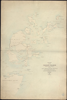 | ||
| Zoom Into Map: | Click on the map to view in greater detail. | |
| Name: | Stevenson, Robert, 1772-1850 | |
| Description: | Zetland. Chart referred to in report on Post Office Packet Station | |
| Year: | 1834 | |
| Place: | Shetland | |
| County: | Zetland | |
| Subject: | Reference Material | |
| Inventory: | Drawing | |
| Colour: | Colour | |
| Media: | None | |
| Object: | Flat | |
| Physical: | Card | |
| Size: | 975 x 640 mm | |
| Shelfmark: | MS.5864, 12 | |
| Show location on map ? | ||
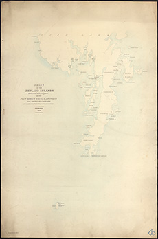 | ||
| Zoom Into Map: | Click on the map to view in greater detail. | |
| Name: | Stevenson, Robert, 1772-1850 ; Stevenson, Alan, 1807-1865 | |
| Description: | Forth, Firth of. Survey from Queensferry to Inchkeith shwoing proposed harbour at Granton | |
| Year: | 1834 | |
| Subject: | River | |
| Inventory: | ||
| Colour: | B&W | |
| Media: | Ink; Printed | |
| Object: | Flat | |
| Physical: | Paper | |
| Size: | 715 mm x 962 mm | |
| Shelfmark: | MS.5850, 35 | |
| Show location on map ? | ||
| Name: | Stevenson, Robert, 1772-1850 | |
| Description: | Cockenzie. Harbour, East Pier and excavation of area | |
| Year: | 1834 and 1841 | |
| Place: | Cockenzie | |
| County: | East Lothian | |
| Subject: | Harbour | |
| Inventory: | Series of five drawings | |
| Colour: | Colour | |
| Media: | Hand coloured; Ink | |
| Object: | Flat | |
| Physical: | Paper | |
| Size: | 582 mm x 866 mm | |
| Shelfmark: | MS.5846, 79 | |
| Show location on map ? | ||
| Name: | Stevenson, Robert, 1772-1850 | |
| Description: | Edinburgh: Canongate. Survey of Tan Work of Messrs. Wm. & Oliver Gilmore | |
| Year: | 1834 | |
| Place: | Edinburgh, Canongate | |
| County: | Edinburgh | |
| Subject: | Building/Monument | |
| Inventory: | Drawing | |
| Colour: | Colour | |
| Media: | Graphite; Hand coloured; Ink | |
| Object: | Flat | |
| Physical: | Paper | |
| Size: | 547 mm x 753 mm | |
| Shelfmark: | MS.5848, 16 | |
| Show location on map ? | ||
| Name: | Stevenson, Robert, 1772-1850 ; Stevenson, Alan, 1807-1865 | |
| Description: | Edinburgh: Granton. Proposed harbour | |
| Year: | 1834 | |
| Place: | Granton | |
| County: | Edinburgh | |
| Subject: | Harbour | |
| Inventory: | Print by W.H. Lizars | |
| Colour: | Colour | |
| Media: | Hand coloured; Printed | |
| Object: | Folded | |
| Physical: | Paper | |
| Size: | 675 mm x 975 mm | |
| Shelfmark: | MS.5848, 46 | |
| Show location on map ? | ||
| Name: | Stevenson, Robert, 1772-1850 ; Stevenson, Alan, 1807-1865 | |
| Description: | Edinburgh: Granton. Proposed harbour | |
| Year: | 1834 | |
| Place: | Granton | |
| County: | Edinburgh | |
| Subject: | Harbour | |
| Inventory: | Drawing | |
| Shelfmark: | MC.5848, 46A - Map.Rol.d.9 | |
| Show location on map ? | ||
| Name: | Stevenson, Robert, 1772-1850 ; Stevenson, Alan, 1807-1865 | |
| Description: | Edinburgh: Granton. Proposed harbour | |
| Year: | 1834 | |
| Place: | Granton | |
| County: | Edinburgh | |
| Subject: | Harbour | |
| Inventory: | ||
| Colour: | Colour | |
| Media: | Hand coloured; Ink; Printed | |
| Object: | Flat | |
| Physical: | Paper | |
| Size: | 340 mm x 380 mm | |
| Shelfmark: | MS.5848, 47 | |
| Show location on map ? | ||
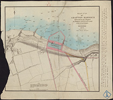 | ||
| Zoom Into Map: | Click on the map to view in greater detail. | |
| Name: | Stevenson, Robert, 1772-1850 | |
| Description: | Edinburgh: Granton. Plan of road from Granton Pier to Leith and Queensferry Road | |
| Year: | 1835 | |
| Place: | Granton | |
| County: | Edinburgh | |
| Subject: | Road | |
| Inventory: | Series of 4 drawings | |
| Colour: | Colour | |
| Media: | Hand coloured; Printed | |
| Object: | Flat | |
| Physical: | Paper/Linen/Cloth | |
| Size: | 465 mm x 385 mm | |
| Shelfmark: | MS.5848, 48 | |
| Show location on map ? | ||
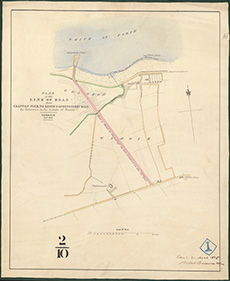 | ||
| Zoom Into Map: | Click on the map to view in greater detail. | |
| Name: | Stevenson, Robert, 1772-1850 | |
| Description: | Edinburgh: Granton. Plan of road from Granton Pier to Leith and Queensferry Road | |
| Year: | 1835 | |
| Place: | Granton | |
| County: | Edinburgh | |
| Subject: | Road | |
| Inventory: | Series of 4 drawings | |
| Colour: | Colour | |
| Media: | Hand coloured; Printed | |
| Object: | Flat | |
| Physical: | Paper | |
| Size: | 410 mm x 345 mm | |
| Shelfmark: | MS.5848, 49 | |
| Show location on map ? | ||
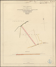 | ||
| Zoom Into Map: | Click on the map to view in greater detail. | |
| Name: | Stevenson, Robert, 1772-1850 | |
| Description: | Edinburgh: Granton. Plan of road from Granton Pier to Leith and Queensferry Road | |
| Year: | 1835 | |
| Place: | Granton | |
| County: | Edinburgh | |
| Subject: | Road | |
| Inventory: | Series of 4 drawings | |
| Colour: | Colour | |
| Media: | Hand coloured; Printed | |
| Object: | Flat | |
| Physical: | Paper | |
| Size: | 375 mm x 313 mm | |
| Shelfmark: | MS.5848, 50 | |
| Show location on map ? | ||
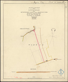 | ||
| Zoom Into Map: | Click on the map to view in greater detail. | |
| Name: | Stevenson, Robert, 1772-1850 | |
| Description: | Edinburgh: Granton. Plan of road from Granton Pier to Leith and Queensferry Road | |
| Year: | 1835 | |
| Place: | Granton | |
| County: | Edinburgh | |
| Subject: | Road | |
| Inventory: | Series of 4 drawings | |
| Colour: | Colour | |
| Media: | Hand coloured; Ink | |
| Object: | Flat | |
| Physical: | Paper | |
| Size: | 525 mm x 380 mm | |
| Shelfmark: | MS.5848, 51 | |
| Show location on map ? | ||
 | ||
| Zoom Into Map: | Click on the map to view in greater detail. | |
| Name: | Stevenson, Robert, 1772-1850 ; Stevenson, Alan, 1807-1865 | |
| Description: | Edinburgh: Granton. Plan and section of a wharf on the Ox Craig | |
| Year: | 1835 | |
| Place: | Granton | |
| County: | Edinburgh | |
| Subject: | Harbour | |
| Inventory: | Drawing. 2 copies | |
| Colour: | Colour | |
| Media: | Hand coloured; Ink | |
| Object: | Flat | |
| Physical: | Paper/Linen/Cloth | |
| Size: | 685 mm x 960 mm | |
| Shelfmark: | MS.5848, 53 | |
| Show location on map ? | ||
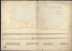 | ||
| Zoom Into Map: | Click on the map to view in greater detail. | |
| Name: | Stevenson, Robert, 1772-1850 ; Stevenson, Alan, 1807-1865 | |
| Description: | Edinburgh: Granton. Plan and section of a wharf on the Ox Craig | |
| Year: | 1835 | |
| Place: | Granton | |
| County: | Edinburgh | |
| Subject: | Harbour | |
| Inventory: | Drawing. 2 copies | |
| Colour: | Colour | |
| Media: | Hand coloured; Ink | |
| Object: | Flat | |
| Physical: | Paper | |
| Size: | 680 mm x 1004 mm | |
| Shelfmark: | MS.5848, 54 | |
| Show location on map ? | ||
| Name: | Stevenson, Robert, 1772-1850 | |
| Description: | Cockenzie. Harbour, East Pier and excavation of area | |
| Year: | 1835 and 1841 | |
| Place: | Cockenzie | |
| County: | East Lothian | |
| Subject: | Harbour | |
| Inventory: | Series of five drawings | |
| Colour: | Colour | |
| Media: | Hand coloured; Ink | |
| Object: | Flat | |
| Physical: | Paper | |
| Size: | 510 mm x 560 mm | |
| Shelfmark: | MS.5846, 80 | |
| Show location on map ? | ||
| Name: | Stevenson, Robert, 1772-1850 | |
| Description: | Cairns, Easter. Plan for proposed reservoir | |
| Year: | 1835 | |
| County: | Edinburgh ; Peebles | |
| Subject: | Water Supply Works | |
| Inventory: | Drawing | |
| Colour: | Colour | |
| Media: | Graphite; Hand coloured; Ink | |
| Object: | Flat | |
| Physical: | Paper | |
| Size: | 775 mm x 750 mm | |
| Shelfmark: | MS.5846, 2 | |
| Show location on map ? | ||
| Name: | Stevenson, Robert, 1772-1850 ; Ritson, James | |
| Description: | Esk, River, South. Survey of mouth at Musselburgh | |
| Year: | 1835 | |
| Place: | Musselburgh | |
| County: | Edinburgh | |
| Subject: | River | |
| Inventory: | Drawing | |
| Colour: | Colour | |
| Media: | Hand coloured; Ink | |
| Object: | Folded | |
| Physical: | Paper/Linen/Cloth | |
| Size: | 730 mm x 1280 mm | |
| Shelfmark: | MS.5849, 134 | |
| Show location on map ? | ||
| Name: | Stevenson, Robert, 1772-1850 | |
| Description: | Edinburgh, Railways. Edin & Glasgow - Section | |
| Year: | 1835 | |
| County: | Dunbarton ; Edinburgh ; Lanark ; Stirling ; West Lothian | |
| Subject: | Railway | |
| Inventory: | Drawing | |
| Colour: | Colour | |
| Media: | Hand coloured; Ink | |
| Object: | Flat | |
| Physical: | Paper/Linen/Cloth | |
| Size: | 245 mm x 1290 mm | |
| Shelfmark: | MS.5849, 86 | |
| Show location on map ? | ||
 | ||
| Zoom Into Map: | Click on the map to view in greater detail. | |
| Name: | Stevenson, Robert, 1772-1850 ; Ritson, James | |
| Description: | Elgin. Harbour and sections | |
| Year: | 1835 | |
| Place: | Elgin | |
| County: | Elgin | |
| Subject: | Harbour | |
| Inventory: | Drawing | |
| Colour: | Colour | |
| Media: | Hand coloured; Ink | |
| Object: | Folded | |
| Physical: | Paper/Linen/Cloth | |
| Size: | 735 mm x 1270 mm | |
| Shelfmark: | MS.5849, 105 | |
| Show location on map ? | ||
| Name: | Stevenson, Robert, 1772-1850 | |
| Description: | Fisherrow. Harbours, survey and sections of proposed improvements | |
| Year: | 1835 | |
| Place: | Fisherrow | |
| County: | Edinburgh | |
| Subject: | Harbour | |
| Inventory: | Drawing | |
| Colour: | Colour | |
| Media: | Graphite; Hand coloured; Ink | |
| Object: | Folded | |
| Physical: | Paper/Linen/Cloth | |
| Size: | 740 mm x 1270 mm | |
| Shelfmark: | MS.5850, 16 | |
| Show location on map ? | ||
| Name: | Stevenson, Robert, 1772-1850 | |
| Description: | Fisherrow. Harbours, survey and sections of proposed improvements | |
| Year: | 1835 | |
| Place: | Fisherrow | |
| County: | Edinburgh | |
| Subject: | Harbour | |
| Inventory: | Drawing | |
| Colour: | Colour | |
| Media: | Hand coloured; Ink | |
| Object: | Flat | |
| Physical: | Paper/Linen/Cloth | |
| Size: | 642 mm x 967 mm | |
| Shelfmark: | MS.5850, 17 | |
| Show location on map ? | ||
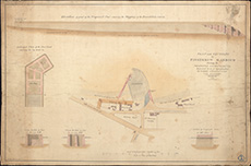 | ||
| Zoom Into Map: | Click on the map to view in greater detail. | |
| Name: | Stevenson, Robert, 1772-1850 | |
| Description: | Edinburgh, Leith and Glasgow Railway. Plans and Section of the Edinburgh, Leith and Glasgow Railway. Robert Stevenson, 1835. | |
| Year: | 1835 | |
| County: | Dunbarton ; Edinburgh ; Fife ; Lanark ; Renfrew ; Stirling ; West Lothian | |
| Subject: | Railway | |
| Colour: | Colour | |
| Media: | Linen/Cloth | |
| Object: | Folded | |
| Physical: | Paper | |
| Size: | 655 x 2000 mm | |
| Shelfmark: | Acc.10706, 424 | |
| Show location on map ? | ||
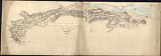 | ||
| Zoom Into Map: | Click on the map to view in greater detail. | |
| Name: | Stevenson, Robert, 1772-1850 | |
| Description: | Perth to Crieff Railway. Scroll plan and sections of proposed railway line from Perth to Crieff. Robert Stevenson, 1835. | |
| Year: | 1835 | |
| County: | Perth | |
| Subject: | Railway | |
| Colour: | Colour | |
| Media: | Linen/Cloth | |
| Object: | Folded | |
| Physical: | Paper | |
| Size: | 585 x 2700 mm | |
| Shelfmark: | Acc.10706, 450 | |
| Show location on map ? | ||
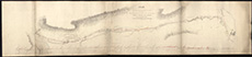 | ||
| Zoom Into Map: | Click on the map to view in greater detail. | |
| Name: | Stevenson, Robert, 1772-1850 | |
| Description: | Orkney. Plan of South Isles in reference to proposed improvements on the Post Packet Stations | |
| Year: | 1835 | |
| Place: | Orkney | |
| County: | Orkney | |
| Subject: | Reference Material | |
| Inventory: | Drawing | |
| Colour: | Colour | |
| Media: | Hand coloured; Ink | |
| Object: | Folded | |
| Physical: | Paper | |
| Size: | 1300 mm x 1000 mm | |
| Shelfmark: | MS.5858, 4 | |
| Show location on map ? | ||
| Name: | Stevenson, Robert, 1772-1850 ; Ritson, James | |
| Description: | Lossiemouth. Harbour: plans and sections | |
| Year: | 1835 | |
| Place: | Lossiemouth | |
| County: | Elgin | |
| Subject: | Harbour | |
| Inventory: | Drawing | |
| Colour: | Colour | |
| Media: | Graphite; Hand coloured; Ink | |
| Object: | Flat | |
| Physical: | Paper | |
| Size: | 773 mm x 1320 mm | |
| Shelfmark: | MS.5855, 64 | |
| Show location on map ? | ||
| Name: | Stevenson, Robert, 1772-1850 ; Stevenson, Alan, 1807-1865 | |
| Description: | Perth. Plan, section and elevation of side walls of dock, to be constructed in Brick | |
| Year: | 1835 | |
| Place: | Perth | |
| County: | Perth | |
| Subject: | Harbour | |
| Inventory: | Drawing | |
| Colour: | Colour | |
| Media: | Hand coloured; Ink | |
| Object: | Flat | |
| Physical: | Paper | |
| Size: | 680 mm x 1000 mm | |
| Shelfmark: | MS.5859, 21 | |
| Show location on map ? | ||
| Name: | Stevenson, Robert, 1772-1850 ; Stevenson, Alan, 1807-1865 | |
| Description: | Perth. Plan and sections of proposed harbour works | |
| Year: | 1835 | |
| Place: | Perth | |
| County: | Perth | |
| Subject: | Harbour | |
| Inventory: | Drawing | |
| Colour: | Colour | |
| Media: | Hand coloured; Ink | |
| Object: | Folded | |
| Physical: | Paper/Linen/Cloth | |
| Size: | 660 mm x 970 mm | |
| Shelfmark: | MS.5859, 22 | |
| Show location on map ? | ||
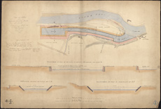 | ||
| Zoom Into Map: | Click on the map to view in greater detail. | |
| Name: | Stevenson, Robert, 1772-1850 ; Stevenson, Alan, 1807-1865 | |
| Description: | Perth. Harbour - survey of grounds between South Inch and Friarton Quay needed for site of proposed harbour | |
| Year: | 1835 | |
| Place: | Perth | |
| County: | Perth | |
| Subject: | Harbour | |
| Inventory: | Drawing | |
| Colour: | Colour | |
| Media: | Hand coloured; Ink | |
| Object: | Flat | |
| Physical: | Paper | |
| Size: | 600 mm x 830 mm | |
| Shelfmark: | MS.5859, 23 | |
| Show location on map ? | ||
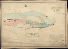 | ||
| Zoom Into Map: | Click on the map to view in greater detail. | |
| Name: | Stevenson, Robert, 1772-1850 | |
| Description: | Lamington. Part of estate, and sections of embankment | |
| Year: | 1835 | |
| Place: | Lamington | |
| County: | Lanark | |
| Subject: | River | |
| Inventory: | Drawing | |
| Colour: | Colour | |
| Media: | Hand coloured; Ink | |
| Object: | Flat | |
| Physical: | Paper | |
| Size: | 670 mm x 1005 mm | |
| Shelfmark: | MS.5855, 1 | |
| Show location on map ? | ||
| Name: | Stevenson, Robert, 1772-1850 ; Stevenson, Alan, 1807-1865 | |
| Description: | Perth. Elevation and section of wooden jetties for tide basin | |
| Year: | 1836 | |
| Place: | Perth | |
| County: | Perth | |
| Subject: | Harbour | |
| Inventory: | Series of 4 drawings | |
| Colour: | Colour | |
| Media: | Ink | |
| Object: | Flat | |
| Physical: | Transparent paper/Paper | |
| Size: | 550 mm x 380 mm | |
| Shelfmark: | MS.5859, 24 | |
| Show location on map ? | ||
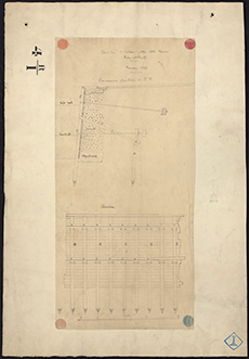 | ||
| Zoom Into Map: | Click on the map to view in greater detail. | |
| Name: | Stevenson, Robert, 1772-1850 ; Stevenson, Alan, 1807-1865 | |
| Description: | Perth. Elevation and section of wooden jetties for tide basin | |
| Year: | 1836 | |
| Place: | Perth | |
| County: | Perth | |
| Subject: | Harbour | |
| Inventory: | Series of 4 drawings | |
| Colour: | Colour | |
| Media: | Hand coloured; Ink | |
| Object: | Flat | |
| Physical: | Transparent paper | |
| Size: | 380 mm x 480 mm | |
| Shelfmark: | MS.5859, 25 | |
| Show location on map ? | ||
| Name: | Stevenson, Robert, 1772-1850 ; Stevenson, Alan, 1807-1865 | |
| Description: | Perth. Elevation and section of wooden jetties for tide basin | |
| Year: | 1836 | |
| Place: | Perth | |
| County: | Perth | |
| Subject: | Harbour | |
| Inventory: | Series of 4 drawings | |
| Colour: | Colour | |
| Media: | Ink | |
| Object: | Flat | |
| Physical: | Transparent paper/Paper | |
| Size: | 550 mm x 670 mm | |
| Shelfmark: | MS.5859, 26 | |
| Show location on map ? | ||
| Name: | Stevenson, Robert, 1772-1850 ; Stevenson, Alan, 1807-1865 | |
| Description: | Perth. Elevation and section of wooden jetties for tide basin | |
| Year: | 1836 | |
| Place: | Perth | |
| County: | Perth | |
| Subject: | Harbour | |
| Inventory: | Series of 4 drawings | |
| Colour: | Colour | |
| Media: | Hand coloured; Ink | |
| Object: | Flat | |
| Physical: | Paper | |
| Size: | 670 mm x 1000 mm | |
| Shelfmark: | MS.5859, 27 | |
| Show location on map ? | ||
| Name: | Stevenson, Robert, 1772-1850 ; Stevenson, Alan, 1807-1865 | |
| Description: | Perth. Plan & section of apparatus for removing sand Banks by Freshes & receding tides | |
| Year: | 1836 | |
| Place: | Perth | |
| County: | Perth | |
| Subject: | Harbour | |
| Inventory: | Tracing | |
| Colour: | Colour | |
| Media: | Ink | |
| Object: | Flat | |
| Physical: | Transparent paper/Paper | |
| Size: | 550 mm x 660 mm | |
| Shelfmark: | MS.5859, 28 | |
| Show location on map ? | ||
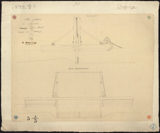 | ||
| Zoom Into Map: | Click on the map to view in greater detail. | |
| Name: | Stevenson, Robert, 1772-1850 ; Stevenson, Alan, 1807-1865 | |
| Description: | Edinburgh and Dundee Railway. Plan of the Edinburgh and Dundee Railway from a survey by Robert Stevenson & Son, 1836. | |
| Year: | 1836 | |
| County: | Edinburgh ; Fife ; Forfar ; Kinross ; Perth ; West Lothian | |
| Subject: | Railway | |
| Colour: | B&W | |
| Media: | None | |
| Object: | Flat | |
| Physical: | Paper | |
| Size: | 350 x 690 mm | |
| Shelfmark: | Acc.10706, 418 | |
| Show location on map ? | ||
| Name: | Stevenson, Robert, 1772-1850 | |
| Description: | Springfield. Plan of road and sections | |
| Year: | 1836 | |
| Place: | Edinburgh, Springfield | |
| County: | Edinburgh | |
| Subject: | Road | |
| Inventory: | Drawing | |
| Colour: | Colour | |
| Media: | None | |
| Object: | Flat | |
| Physical: | Card | |
| Size: | 775 x 1900 mm | |
| Shelfmark: | MS.5862, 102 | |
| Show location on map ? | ||
| Name: | Stevenson, Robert, 1772-1850 | |
| Description: | Elie. Harbour- sections for proposed wharfs | |
| Year: | 1836 | |
| Place: | Elie | |
| County: | Fife | |
| Subject: | Harbour | |
| Inventory: | Drawing | |
| Colour: | Colour | |
| Media: | Hand coloured; Ink | |
| Object: | Folded | |
| Physical: | Paper | |
| Size: | 655 mm x 1415 mm | |
| Shelfmark: | MS.5849, 107 | |
| Show location on map ? | ||
| Name: | Stevenson, Robert, 1772-1850 | |
| Description: | Edinburgh, Railways. Edinburgh & Dundee | |
| Year: | 1836 | |
| County: | Edinburgh ; Fife ; Forfar ; Kinross ; Perth ; West Lothian | |
| Subject: | Railway | |
| Inventory: | ||
| Colour: | B&W | |
| Media: | Printed | |
| Object: | Flat | |
| Physical: | Paper | |
| Size: | 390 mm x 760 mm | |
| Shelfmark: | MS.5849, 85 - Mc | |
| Show location on map ? | ||
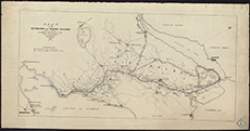 | ||
| Zoom Into Map: | Click on the map to view in greater detail. | |
| Name: | Stevenson, Robert, 1772-1850 | |
| Description: | Cairns, Easter. Reservoir and sections of embankment | |
| Year: | 1836 | |
| County: | Edinburgh ; Peebles | |
| Subject: | Water Supply Works | |
| Inventory: | Drawing | |
| Colour: | Colour | |
| Media: | Graphite; Hand coloured; Ink | |
| Object: | Folded | |
| Physical: | Paper/Linen/Cloth | |
| Size: | 745 mm x 1290 mm | |
| Shelfmark: | MS.5846, 4 | |
| Show location on map ? | ||
| Name: | Stevenson, Robert, 1772-1850 | |
| Description: | Cockenzie. Harbour, East Pier and excavation of area | |
| Year: | 1836 and 1841 | |
| Place: | Cockenzie | |
| County: | East Lothian | |
| Subject: | Harbour | |
| Inventory: | Series of five drawings | |
| Colour: | Colour | |
| Media: | Hand coloured; Ink | |
| Object: | Flat | |
| Physical: | Paper | |
| Size: | 627 mm x 876 mm | |
| Shelfmark: | MS.5846, 81 | |
| Show location on map ? | ||
| Name: | Stevenson, Robert, 1772-1850 ; Stevenson, Alan, 1807-1865 | |
| Description: | Edinburgh: Granton. Plan and section of road | |
| Year: | 1836 | |
| Place: | Granton | |
| County: | Edinburgh | |
| Subject: | Road | |
| Inventory: | Drawing | |
| Colour: | Colour | |
| Media: | Hand coloured; Ink | |
| Object: | Flat | |
| Physical: | Paper | |
| Size: | 564 mm x 721 mm | |
| Shelfmark: | MS.5848, 56 | |
| Show location on map ? | ||
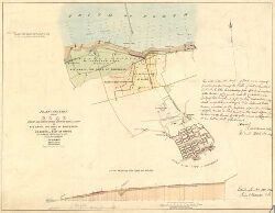 | ||
| Zoom Into Map: | Click on the map to view in greater detail. | |
| Name: | Stevenson, Robert, 1772-1850 | |
| Description: | Earn River. Bridge: plan and section of roadway | |
| Year: | 1836 | |
| Place: | Bridge of Earn | |
| County: | Perth | |
| Subject: | Bridge | |
| Inventory: | Drawing | |
| Colour: | Colour | |
| Media: | Hand coloured; Ink | |
| Object: | Folded | |
| Physical: | Paper | |
| Size: | 740 mm x 1333 mm | |
| Shelfmark: | MS.5848, 2 | |
| Show location on map ? | ||
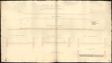 | ||
| Zoom Into Map: | Click on the map to view in greater detail. | |
| Name: | Stevenson, Robert, 1772-1850 ; Stevenson, Alan, 1807-1865 | |
| Description: | Cromarty, Firth. Firth and part of River Conon | |
| Year: | 1837-8 | |
| County: | Ross And Cromarty | |
| Subject: | River | |
| Inventory: | Drawing | |
| Colour: | Colour | |
| Media: | Hand coloured; Ink | |
| Object: | Folded | |
| Physical: | Paper/Linen/Cloth | |
| Size: | 654 mm x 2090 mm | |
| Shelfmark: | MS.5846, 128 | |
| Show location on map ? | ||
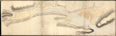 | ||
| Zoom Into Map: | Click on the map to view in greater detail. | |
| Name: | Stevenson, Robert, 1772-1850 ; Stevenson, Alan, 1807-1865 | |
| Description: | Edinburgh: Granton. Sections of Granton Road | |
| Year: | 1837 | |
| Place: | Granton | |
| County: | Edinburgh | |
| Subject: | Road | |
| Inventory: | Drawing | |
| Colour: | Colour | |
| Media: | Hand coloured; Ink | |
| Object: | Flat | |
| Physical: | Paper | |
| Size: | 374 mm x 532 mm | |
| Shelfmark: | MS.5848, 57 | |
| Show location on map ? | ||
| Name: | Stevenson, Robert, 1772-1850 | |
| Description: | Cockenzie. Harbour, East Pier and excavation of area | |
| Year: | 1837 and 1841 | |
| Place: | Cockenzie | |
| County: | East Lothian | |
| Subject: | Harbour | |
| Inventory: | Series of five drawings | |
| Colour: | Colour | |
| Media: | Graphite; Hand coloured; Ink | |
| Object: | Flat | |
| Physical: | Paper | |
| Size: | 652 mm x 955 mm | |
| Shelfmark: | MS.5846, 82 | |
| Show location on map ? | ||
| Name: | Stevenson, Robert, 1772-1850 | |
| Description: | Edinburgh, Leith. Plan and section of part of building yard | |
| Year: | 1837 | |
| Place: | Leith | |
| County: | Edinburgh | |
| Subject: | Building/Monument | |
| Inventory: | Drawing | |
| Colour: | Colour | |
| Media: | Hand coloured; Ink | |
| Object: | Flat | |
| Physical: | Paper | |
| Size: | 545 mm x 660 mm | |
| Shelfmark: | MS.5848, 74 | |
| Show location on map ? | ||
| Name: | Stevenson, Robert, 1772-1850 | |
| Description: | Edinburgh, Leith. Sections of proposed walls | |
| Year: | 1837 | |
| Place: | Leith | |
| County: | Edinburgh | |
| Subject: | Building/Monument | |
| Inventory: | Drawing | |
| Colour: | Colour | |
| Media: | Hand coloured; Ink | |
| Object: | Flat | |
| Physical: | Paper | |
| Size: | 760 mm x 551 mm | |
| Shelfmark: | MS.5848, 75 | |
| Show location on map ? | ||
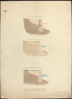 | ||
| Zoom Into Map: | Click on the map to view in greater detail. | |
| Name: | Stevenson, Robert, 1772-1850 | |
| Description: | Tweed, River. Plans relating to proposed bridge | |
| Year: | 1837 | |
| County: | Berwick | |
| Subject: | Bridge | |
| Inventory: | Drawing | |
| Colour: | Colour | |
| Media: | None | |
| Object: | Flat | |
| Physical: | Card | |
| Size: | 740 x 990 mm | |
| Shelfmark: | MS.5863, 108 | |
| Show location on map ? | ||
| Name: | Stevenson, Robert, 1772-1850 | |
| Description: | Roads and Bridges - Norham Bridge no.3. Plan, elevation and cross-section of a bridge over the Tweed. Robert Stevenson, 1838. | |
| Year: | 1838 | |
| Place: | Ladykirk & Norham Bridge | |
| County: | Berwick | |
| Subject: | Bridge | |
| Colour: | Colour | |
| Object: | Flat | |
| Size: | 620 x 970 mm | |
| Shelfmark: | Acc.10706, 492 | |
| Show location on map ? | ||
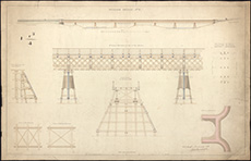 | ||
| Zoom Into Map: | Click on the map to view in greater detail. | |
| Name: | Stevenson, Robert, 1772-1850 | |
| Description: | Edinburgh, London Road. Cross Sections | |
| Year: | 1838 | |
| Place: | Edinburgh, London Road | |
| County: | Edinburgh | |
| Subject: | Road | |
| Inventory: | Drawing | |
| Colour: | Colour | |
| Media: | Hand coloured; Ink | |
| Object: | Folded | |
| Physical: | Paper | |
| Size: | 320 mm x 1680 mm | |
| Shelfmark: | MS.5849, 8 | |
| Show location on map ? | ||
 | ||
| Zoom Into Map: | Click on the map to view in greater detail. | |
| Name: | Stevenson, Robert, 1772-1850 | |
| Description: | Edinburgh, Leith, Water of. Position of weir proposes to be constructed near St. Bernards Well | |
| Year: | 1839 | |
| Place: | Edinburgh, Leith, Water of | |
| County: | Edinburgh | |
| Subject: | River | |
| Inventory: | Series of 3 drawings | |
| Colour: | Colour | |
| Media: | Graphite; Hand coloured; Ink | |
| Object: | Folded | |
| Physical: | Paper | |
| Size: | 680 mm x 920 mm | |
| Shelfmark: | MS.5848, 101-103 | |
| Show location on map ? | ||
| Name: | Stevenson, Robert, 1772-1850 | |
| Description: | Fisherrow. Harbour with proposed new works | |
| Year: | 1839 | |
| Place: | Fisherrow | |
| County: | Edinburgh | |
| Subject: | Harbour | |
| Inventory: | Series of 7 prints by Lizars | |
| Colour: | Colour | |
| Media: | Hand coloured; Printed | |
| Object: | Flat | |
| Physical: | Paper | |
| Size: | 360 mm x 694 mm | |
| Shelfmark: | MS.5850, 18 | |
| Show location on map ? | ||
| Name: | Stevenson, Robert, 1772-1850 | |
| Description: | Fisherrow. Harbour with proposed new works | |
| Year: | 1839 | |
| Place: | Fisherrow | |
| County: | Edinburgh | |
| Subject: | Harbour | |
| Inventory: | Series of 7 prints by Lizars | |
| Colour: | Colour | |
| Media: | Hand coloured; Printed | |
| Object: | Flat | |
| Physical: | Paper | |
| Size: | 355 mm x 705 mm | |
| Shelfmark: | MS.5850, 19 | |
| Show location on map ? | ||
| Name: | Stevenson, Robert, 1772-1850 | |
| Description: | Fisherrow. Harbour with proposed new works | |
| Year: | 1839 | |
| Place: | Fisherrow | |
| County: | Edinburgh | |
| Subject: | Harbour | |
| Inventory: | Series of 7 prints by Lizars | |
| Colour: | Colour | |
| Media: | Hand coloured; Printed | |
| Object: | Flat | |
| Physical: | Paper/Linen/Cloth | |
| Size: | 400 mm x 700 mm | |
| Shelfmark: | MS.5850, 20 | |
| Show location on map ? | ||
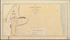 | ||
| Zoom Into Map: | Click on the map to view in greater detail. | |
| Name: | Stevenson, Robert, 1772-1850 | |
| Description: | Fisherrow. Harbour with proposed new works | |
| Year: | 1839 | |
| Place: | Fisherrow | |
| County: | Edinburgh | |
| Subject: | Harbour | |
| Inventory: | Series of 7 prints by Lizars | |
| Colour: | B&W | |
| Media: | Printed | |
| Object: | Flat | |
| Physical: | Paper | |
| Size: | 400 mm x 710 mm | |
| Shelfmark: | MS.5850, 21 | |
| Show location on map ? | ||
| Name: | Stevenson, Robert, 1772-1850 | |
| Description: | Fisherrow. Harbour with proposed new works | |
| Year: | 1839 | |
| Place: | Fisherrow | |
| County: | Edinburgh | |
| Subject: | Harbour | |
| Inventory: | Series of 7 prints by Lizars | |
| Colour: | Colour | |
| Media: | Hand coloured; Ink | |
| Object: | Folded | |
| Physical: | Paper/Linen/Cloth | |
| Size: | 650 mm x 970 mm | |
| Shelfmark: | MS.5850, 22 | |
| Show location on map ? | ||
| Name: | Stevenson, Robert, 1772-1850 | |
| Description: | Fisherrow. Harbour with proposed new works | |
| Year: | 1839 | |
| Place: | Fisherrow | |
| County: | Edinburgh | |
| Subject: | Harbour | |
| Inventory: | Series of 7 prints by Lizars | |
| Colour: | Colour | |
| Media: | Graphite; Hand coloured; Ink | |
| Object: | Flat | |
| Physical: | Paper/Linen/Cloth | |
| Size: | 400 mm x 700 mm | |
| Shelfmark: | MS.5851, 22A | |
| Show location on map ? | ||
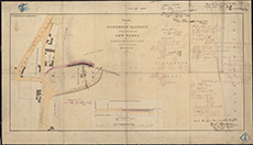 | ||
| Zoom Into Map: | Click on the map to view in greater detail. | |
| Name: | Stevenson, Robert, 1772-1850 | |
| Description: | Fisherrow. Harbour with proposed new works | |
| Year: | 1839 | |
| Place: | Fisherrow | |
| County: | Edinburgh | |
| Subject: | Harbour | |
| Inventory: | Series of 7 prints by Lizars | |
| Colour: | B&W | |
| Media: | Ink; Printed | |
| Object: | Flat | |
| Physical: | Paper | |
| Size: | 408 mm x 708 mm | |
| Shelfmark: | MS.5850, 23 | |
| Show location on map ? | ||
| Name: | Stevenson, Robert, 1772-1850 | |
| Description: | Fisherrow. Harbour with proposed new works | |
| Year: | 1839 | |
| Place: | Fisherrow | |
| County: | Edinburgh | |
| Subject: | Harbour | |
| Inventory: | Series of 7 prints by Lizars | |
| Colour: | Colour | |
| Media: | Graphite; Hand coloured; Ink | |
| Object: | Flat | |
| Physical: | Paper | |
| Size: | 362 mm x 687 mm | |
| Shelfmark: | MS.5850, 24 | |
| Show location on map ? | ||
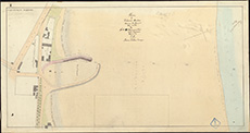 | ||
| Zoom Into Map: | Click on the map to view in greater detail. | |
| Name: | Stevenson, Robert, 1772-1850 | |
| Description: | Greenock. Part of West Burn with ship building yard of J. Scott | |
| Year: | 1839 | |
| Place: | Greenock | |
| County: | Renfrew | |
| Subject: | River | |
| Inventory: | ||
| Colour: | Colour | |
| Media: | Hand coloured; Printed | |
| Object: | Flat | |
| Physical: | Paper | |
| Size: | 450 mm x 565 mm | |
| Shelfmark: | MS.5851, 116 | |
| Show location on map ? | ||
| Name: | Stevenson, Robert, 1772-1850 | |
| Description: | Tay, River. Tay near Dorry Island | |
| Year: | 1839 | |
| County: | Perth | |
| Subject: | River | |
| Inventory: | Drawing | |
| Colour: | Colour | |
| Media: | Paper | |
| Object: | Flat | |
| Physical: | Transparent paper | |
| Size: | 760 x 500 mm | |
| Shelfmark: | MS.5863, 40 | |
| Show location on map ? | ||
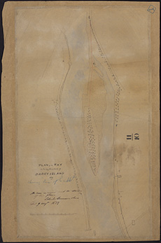 | ||
| Zoom Into Map: | Click on the map to view in greater detail. | |
| Name: | Stevenson, Robert, 1772-1850 | |
| Description: | Tay, River. Cutting at Sand Island | |
| Year: | 1840 | |
| County: | Perth | |
| Subject: | River | |
| Inventory: | Drawing | |
| Colour: | Colour | |
| Media: | None | |
| Object: | Flat | |
| Physical: | Card | |
| Size: | 670 x 1000 mm | |
| Shelfmark: | MS.5863, 41 | |
| Show location on map ? | ||
| Name: | Stevenson, Robert, 1772-1850 ; Stevenson, Alan, 1807-1865 ; Stevenson, David, 1815-1886 | |
| Description: | Allanton. Bridge | |
| Year: | 1840 | |
| Place: | Allanton | |
| County: | Berwick | |
| Subject: | Bridge | |
| Inventory: | Series of six drawings | |
| Colour: | Colour | |
| Media: | Graphite; Hand coloured; Ink | |
| Object: | Flat | |
| Physical: | Paper | |
| Size: | 67 mm x 50 mm | |
| Shelfmark: | MS.5844, 38 | |
| Show location on map ? | ||
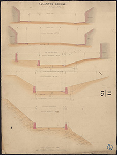 | ||
| Zoom Into Map: | Click on the map to view in greater detail. | |
| Name: | Stevenson, Robert, 1772-1850 ; Stevenson, Alan, 1807-1865 ; Stevenson, David, 1815-1886 | |
| Description: | Allanton. Bridge | |
| Year: | 1840 | |
| Place: | Allanton | |
| County: | Berwick | |
| Subject: | Bridge | |
| Inventory: | Series of six drawings | |
| Colour: | Colour | |
| Media: | Graphite; Hand coloured; Ink | |
| Object: | Flat | |
| Physical: | Paper/Linen/Cloth | |
| Size: | 690 mm x 525 mm | |
| Shelfmark: | MS.5844, 39 | |
| Show location on map ? | ||
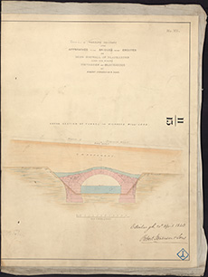 | ||
| Zoom Into Map: | Click on the map to view in greater detail. | |
| Name: | Stevenson, Robert, 1772-1850 ; Stevenson, Alan, 1807-1865 ; Stevenson, David, 1815-1886 | |
| Description: | Allanton. Bridge | |
| Year: | 1840 | |
| Place: | Allanton | |
| County: | Berwick | |
| Subject: | Bridge | |
| Inventory: | Series of six drawings | |
| Colour: | Colour | |
| Media: | Graphite; Hand coloured; Ink | |
| Object: | Folded | |
| Physical: | Paper | |
| Size: | 270 mm x 825 mm | |
| Shelfmark: | MS.5844, 40 | |
| Show location on map ? | ||
 | ||
| Zoom Into Map: | Click on the map to view in greater detail. | |
| Name: | Stevenson, Robert, 1772-1850 ; Stevenson, Alan, 1807-1865 ; Stevenson, David, 1815-1886 | |
| Description: | Allanton. Bridge | |
| Year: | 1840 | |
| Place: | Allanton | |
| County: | Berwick | |
| Subject: | Bridge | |
| Inventory: | Series of six drawings | |
| Colour: | Colour | |
| Media: | Hand coloured; Ink | |
| Object: | Folded | |
| Physical: | Paper | |
| Size: | 260 mm x 845 mm | |
| Shelfmark: | MS.5844, 41 | |
| Show location on map ? | ||
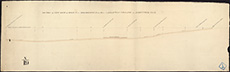 | ||
| Zoom Into Map: | Click on the map to view in greater detail. | |
| Name: | Stevenson, Robert, 1772-1850 ; Stevenson, Alan, 1807-1865 ; Stevenson, David, 1815-1886 | |
| Description: | Allanton. Bridge | |
| Year: | 1840 | |
| Place: | Allanton | |
| County: | Berwick | |
| Subject: | Bridge | |
| Inventory: | Series of six drawings | |
| Colour: | Colour | |
| Media: | Graphite; Hand coloured; Ink | |
| Object: | Flat | |
| Physical: | Paper | |
| Size: | 675 mm x 1005 mm | |
| Shelfmark: | MS.5844, 42 | |
| Show location on map ? | ||
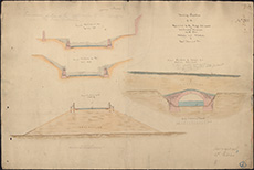 | ||
| Zoom Into Map: | Click on the map to view in greater detail. | |
| Name: | Stevenson, Robert, 1772-1850 ; Stevenson, Alan, 1807-1865 ; Stevenson, David, 1815-1886 | |
| Description: | Allanton. Bridge | |
| Year: | 1840 | |
| Place: | Allanton | |
| County: | Berwick | |
| Subject: | Bridge | |
| Inventory: | Series of six drawings | |
| Colour: | B&W | |
| Media: | Graphite; Ink | |
| Object: | Flat | |
| Physical: | Paper | |
| Size: | 672 mm x 1005 mm | |
| Shelfmark: | MS.5844, 43 | |
| Show location on map ? | ||
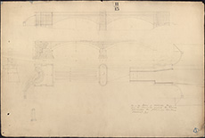 | ||
| Zoom Into Map: | Click on the map to view in greater detail. | |
| Name: | Stevenson, Robert, 1772-1850 ; Stevenson, Alan, 1807-1865 ; Stevenson, David, 1815-1886 | |
| Description: | Allanton. Sections of Bridge | |
| Year: | 1840 | |
| Place: | Allanton | |
| County: | Berwick | |
| Subject: | Bridge | |
| Inventory: | Drawing | |
| Colour: | Colour | |
| Media: | Hand coloured; Ink | |
| Object: | Flat | |
| Physical: | Paper | |
| Size: | 673 mm x 1003 mm | |
| Shelfmark: | MS.5844, 44 | |
| Show location on map ? | ||
| Name: | Stevenson, Robert, 1772-1850 ; Stevenson, Alan, 1807-1865 ; Stevenson, David, 1815-1886 | |
| Description: | Allanton. Longitudinal section of Bridge | |
| Year: | 1840 | |
| Place: | Allanton | |
| County: | Berwick | |
| Subject: | Bridge | |
| Inventory: | Drawing | |
| Colour: | Colour | |
| Media: | Graphite; Hand coloured; Ink | |
| Object: | Flat | |
| Physical: | Paper | |
| Size: | 675 mm x 1003 mm | |
| Shelfmark: | MS.5844, 45 | |
| Show location on map ? | ||
| Name: | Stevenson, Robert, 1772-1850 ; Stevenson, Alan, 1807-1865 ; Stevenson, David, 1815-1887 | |
| Description: | Allanton. Sketch of centre frame of Bridge | |
| Year: | 1840 | |
| Place: | Allanton | |
| County: | Berwick | |
| Subject: | Bridge | |
| Inventory: | Drawing | |
| Colour: | Colour | |
| Media: | Graphite; Hand coloured; Ink | |
| Object: | Flat | |
| Physical: | Paper | |
| Size: | 356 mm x 669 mm | |
| Shelfmark: | MS.5844, 46 | |
| Show location on map ? | ||
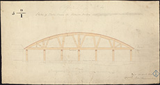 | ||
| Zoom Into Map: | Click on the map to view in greater detail. | |
| Name: | Stevenson, Robert, 1772-1850 ; Stevenson, Alan, 1807-1865 ; Stevenson, David, 1815-1886 | |
| Description: | Allanton. Sketches and Sections | |
| Year: | 1840 | |
| Place: | Allanton | |
| County: | Berwick | |
| Subject: | Bridge | |
| Inventory: | Series of nine drawings | |
| Colour: | Colour | |
| Media: | Graphite; Hand coloured; Printed | |
| Object: | Flat | |
| Physical: | Paper | |
| Size: | 335 mm x 998 mm | |
| Shelfmark: | MS.5844, 47 | |
| Show location on map ? | ||
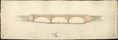 | ||
| Zoom Into Map: | Click on the map to view in greater detail. | |
| Name: | Stevenson, Robert, 1772-1850 ; Stevenson, Alan, 1807-1865 ; Stevenson, David, 1815-1886 | |
| Description: | Allanton. Sketches and Sections | |
| Year: | 1840 | |
| Place: | Allanton | |
| County: | Berwick | |
| Subject: | Bridge | |
| Inventory: | Series of nine drawings | |
| Colour: | Colour | |
| Media: | Graphite; Hand coloured; Printed | |
| Object: | Flat | |
| Physical: | Paper | |
| Size: | 290 mm x 1001 mm | |
| Shelfmark: | MS.5844, 48 | |
| Show location on map ? | ||
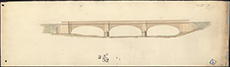 | ||
| Zoom Into Map: | Click on the map to view in greater detail. | |
| Name: | Stevenson, Robert, 1772-1850 ; Stevenson, Alan, 1807-1865 ; Stevenson, David, 1815-1886 | |
| Description: | Allanton. Sketches and Sections | |
| Year: | 1840 | |
| Place: | Allanton | |
| County: | Berwick | |
| Subject: | Bridge | |
| Inventory: | Series of nine drawings | |
| Colour: | Colour | |
| Media: | Graphite; Hand coloured; Ink | |
| Object: | Flat | |
| Physical: | Paper | |
| Size: | 340 mm x 995 mm | |
| Shelfmark: | MS.5844, 49 | |
| Show location on map ? | ||
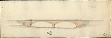 | ||
| Zoom Into Map: | Click on the map to view in greater detail. | |
| Name: | Stevenson, Robert, 1772-1850 ; Stevenson, Alan, 1807-1865 ; Stevenson, David, 1815-1886 | |
| Description: | Allanton. Sketches and Sections | |
| Year: | 1840 | |
| Place: | Allanton | |
| County: | Berwick | |
| Subject: | Bridge | |
| Inventory: | Series of nine drawings | |
| Colour: | Colour | |
| Media: | Graphite; Hand coloured; Ink | |
| Object: | Flat | |
| Physical: | Paper | |
| Size: | 335 mm x 835 mm | |
| Shelfmark: | MS.5844, 50 | |
| Show location on map ? | ||
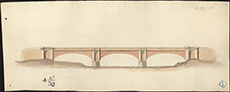 | ||
| Zoom Into Map: | Click on the map to view in greater detail. | |
| Name: | Stevenson, Robert, 1772-1850 ; Stevenson, Alan, 1807-1865 ; Stevenson, David, 1815-1886 | |
| Description: | Allanton. Sketches and Sections | |
| Year: | 1840 | |
| Place: | Allanton | |
| County: | Berwick | |
| Subject: | Bridge | |
| Inventory: | Series of nine drawings | |
| Colour: | Colour | |
| Media: | Hand coloured; Ink | |
| Object: | Flat | |
| Physical: | Paper | |
| Size: | 445 mm x 503 mm | |
| Shelfmark: | MS.5844, 51 | |
| Show location on map ? | ||
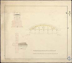 | ||
| Zoom Into Map: | Click on the map to view in greater detail. | |
| Name: | Stevenson, Robert, 1772-1850 ; Stevenson, Alan, 1807-1865 ; Stevenson, David, 1815-1886 | |
| Description: | Allanton. Sketches and Sections | |
| Year: | 1840 | |
| Place: | Allanton | |
| County: | Berwick | |
| Subject: | Bridge | |
| Inventory: | Series of nine drawings | |
| Colour: | Colour | |
| Media: | Hand coloured; Ink | |
| Object: | Flat | |
| Physical: | Paper | |
| Size: | 480 mm x 635 mm | |
| Shelfmark: | MS.5844, 52 | |
| Show location on map ? | ||
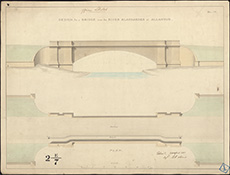 | ||
| Zoom Into Map: | Click on the map to view in greater detail. | |
| Name: | Stevenson, Robert, 1772-1850 ; Stevenson, Alan, 1807-1865 ; Stevenson, David, 1815-1886 | |
| Description: | Allanton. Sketches and Sections | |
| Year: | 1840 | |
| Place: | Allanton | |
| County: | Berwick | |
| Subject: | Bridge | |
| Inventory: | Series of nine drawings | |
| Colour: | Colour | |
| Media: | Graphite; Hand coloured; Ink | |
| Object: | Flat | |
| Physical: | Paper | |
| Size: | 555 mm x 680 mm | |
| Shelfmark: | MS.5844, 53 | |
| Show location on map ? | ||
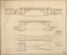 | ||
| Zoom Into Map: | Click on the map to view in greater detail. | |
| Name: | Stevenson, Robert, 1772-1850 ; Stevenson, Alan, 1807-1865 ; Stevenson, David, 1815-1886 | |
| Description: | Allanton. Sketches and Sections | |
| Year: | 1840 | |
| Place: | Allanton | |
| County: | Berwick | |
| Subject: | Bridge | |
| Inventory: | Series of nine drawings | |
| Colour: | Colour | |
| Media: | Graphite; Hand coloured; Ink | |
| Object: | Flat | |
| Physical: | Paper | |
| Size: | 640 mm x 895 mm | |
| Shelfmark: | MS.5844, 54 | |
| Show location on map ? | ||
| Name: | Stevenson, Robert, 1772-1850 ; Stevenson, Alan, 1807-1865 ; Stevenson, David, 1815-1886 | |
| Description: | Allanton. Sketches and Sections | |
| Year: | 1840 | |
| Place: | Allanton | |
| County: | Berwick | |
| Subject: | Bridge | |
| Inventory: | Series of nine drawings | |
| Colour: | Colour | |
| Media: | Hand coloured; Ink | |
| Object: | Flat | |
| Physical: | Paper/Linen/Cloth | |
| Size: | 644 mm x 950 mm | |
| Shelfmark: | MS.5844, 55 | |
| Show location on map ? | ||
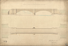 | ||
| Zoom Into Map: | Click on the map to view in greater detail. | |
| Name: | Stevenson, Robert, 1772-1850 ; Stevenson, Alan, 1807-1865 ; Stevenson, David, 1815-1886 | |
| Description: | Allanton. Grounds in vicinity of village with sites of Bridges and connecting roads | |
| Year: | 1840 | |
| Place: | Allanton | |
| County: | Berwick | |
| Subject: | Bridge | |
| Inventory: | Drawing | |
| Colour: | Colour | |
| Media: | Hand coloured; Ink | |
| Object: | Folded | |
| Physical: | Paper/Linen/Cloth | |
| Size: | 750 mm x 1292 mm | |
| Shelfmark: | MS.5844, 56 | |
| Show location on map ? | ||
 | ||
| Zoom Into Map: | Click on the map to view in greater detail. | |
| Name: | Stevenson, Robert, 1772-1850 | |
| Description: | Tay, River. Shore at Carpon showing line of proposed embankment | |
| Year: | 1842 | |
| Place: | Carpow | |
| County: | Perth | |
| Subject: | River | |
| Inventory: | Drawing | |
| Colour: | Colour | |
| Media: | None | |
| Object: | Flat | |
| Physical: | Card | |
| Size: | 620 x 970 mm | |
| Shelfmark: | MS.5863, 43 | |
| Show location on map ? | ||
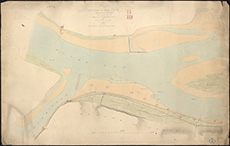 | ||
| Zoom Into Map: | Click on the map to view in greater detail. | |
| Name: | Stevenson, Robert, 1772-1850 | |
| Description: | Harbours - Alloa. Plan and sections showing proposed dock, swivel bridge, lock gates etc, Robert Stevenson. Printed. (paper watermarked 1842) | |
| Year: | 1842 | |
| Place: | Alloa | |
| County: | Clackmannan | |
| Subject: | Harbour | |
| Colour: | Colour | |
| Media: | None | |
| Object: | Flat | |
| Physical: | Card | |
| Size: | 745 x 1245 mm | |
| Shelfmark: | Acc.10706, 290 | |
| Show location on map ? | ||
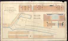 | ||
| Zoom Into Map: | Click on the map to view in greater detail. | |
| Name: | Stevenson, Robert, 1772-1850 | |
| Description: | Tay, River. Newburgh to Flisk Point with jetties | |
| Year: | 1843 | |
| County: | Fife | |
| Subject: | River | |
| Inventory: | Series of 3 prints | |
| Colour: | Colour | |
| Media: | None | |
| Object: | Flat | |
| Physical: | Card | |
| Size: | 480 x 960 mm | |
| Shelfmark: | MS.5863, 44 | |
| Show location on map ? | ||
| Name: | Stevenson, Robert, 1772-1850 | |
| Description: | Tay, River. Newburgh to Flisk Point with jetties | |
| Year: | 1843 | |
| County: | Fife | |
| Subject: | River | |
| Inventory: | Series of 3 prints | |
| Colour: | Colour | |
| Media: | None | |
| Object: | Flat | |
| Physical: | Card | |
| Size: | 470 x 980 mm | |
| Shelfmark: | MS.5863, 45 | |
| Show location on map ? | ||
| Name: | Stevenson, Robert, 1772-1850 | |
| Description: | Tay, River. Newburgh to Flisk Point with jetties | |
| Year: | 1843 | |
| County: | Fife | |
| Subject: | River | |
| Inventory: | Series of 3 prints | |
| Colour: | Colour | |
| Media: | None | |
| Object: | Flat | |
| Physical: | Card | |
| Size: | 470 x 990 mm | |
| Shelfmark: | MS.5863, 46 | |
| Show location on map ? | ||
| Name: | Leslie, James, 1801-1889 ; Stevenson, Robert, 1772-1850 | |
| Description: | Kirkcaldy. Harbour: alternations to east Pier | |
| Year: | 1843 & 1844 | |
| Place: | Kirkcaldy | |
| County: | Fife | |
| Subject: | Harbour | |
| Inventory: | Series of 4 drawings. 1843- Leslie; 1844- Stevenson | |
| Colour: | B&W | |
| Media: | Graphite; Ink | |
| Object: | Flat | |
| Physical: | Transparent paper/Linen/Cloth | |
| Size: | 431 mm x 280 mm | |
| Shelfmark: | MS.5854, 21 | |
| Show location on map ? | ||
| Name: | Leslie, James, 1801-1889 ; Stevenson, Robert, 1772-1850 | |
| Description: | Kirkcaldy. Harbour: alternations to east Pier | |
| Year: | 1843 & 1844 | |
| Place: | Kirkcaldy | |
| County: | Fife | |
| Subject: | Harbour | |
| Inventory: | Series of 4 drawings. 1843- Leslie ; 1844- Stevenson | |
| Colour: | Colour | |
| Media: | Graphite; Hand coloured; Ink | |
| Object: | Flat | |
| Physical: | Paper | |
| Size: | 546 mm x 750 mm | |
| Shelfmark: | MS.5854, 22 | |
| Show location on map ? | ||
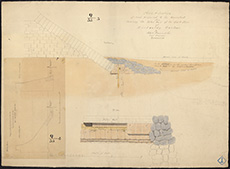 | ||
| Zoom Into Map: | Click on the map to view in greater detail. | |
| Name: | Leslie, James, 1801-1889 ; Stevenson, Robert, 1772-1850 | |
| Description: | Kirkcaldy. Harbour: alternations to east Pier | |
| Year: | 1843 & 1844 | |
| Place: | Kirkcaldy | |
| County: | Fife | |
| Subject: | Harbour | |
| Inventory: | Series of 4 drawings. 1843- Leslie ; 1844- Stevenson | |
| Colour: | B&W | |
| Media: | Ink | |
| Object: | Flat | |
| Physical: | Transparent paper/Linen/Cloth | |
| Size: | 567 mm x 860 mm | |
| Shelfmark: | MS.5854, 23 | |
| Show location on map ? | ||
| Name: | Leslie, James, 1801-1889 ; Stevenson, Robert, 1772-1850 | |
| Description: | Kirkcaldy. Harbour: alternations to east Pier | |
| Year: | 1843 & 1844 | |
| Place: | Kirkcaldy | |
| County: | Fife | |
| Subject: | Harbour | |
| Inventory: | Series of 4 drawings. 1843- Leslie ; 1844- Stevenson | |
| Colour: | B&W | |
| Media: | Ink | |
| Object: | Flat | |
| Physical: | Transparent paper/Linen/Cloth | |
| Size: | 567 mm x 860 mm | |
| Shelfmark: | MS.5854, 24 | |
| Show location on map ? | ||
| Name: | Stevenson, Robert, 1772-1850 | |
| Description: | Fisherrow. Harbour, with proposed Western pier | |
| Year: | 1843 | |
| Place: | Fisherrow | |
| County: | Edinburgh | |
| Subject: | Harbour | |
| Inventory: | Series of 3 drawings | |
| Colour: | Colour | |
| Media: | Graphite; Hand coloured; Ink | |
| Object: | Flat | |
| Physical: | Paper | |
| Size: | 552 mm x 760 mm | |
| Shelfmark: | MS.5850, 25 | |
| Show location on map ? | ||
| Name: | Stevenson, Robert, 1772-1850 | |
| Description: | Fisherrow. Harbour, with proposed Western pier | |
| Year: | 1843 | |
| Place: | Fisherrow | |
| County: | Edinburgh | |
| Subject: | Harbour | |
| Inventory: | Series of 3 drawings | |
| Colour: | Colour | |
| Media: | Hand coloured; Ink | |
| Object: | Flat | |
| Physical: | Paper | |
| Size: | 552 mm x 757 mm | |
| Shelfmark: | MS.5850, 26 | |
| Show location on map ? | ||
| Name: | Stevenson, Robert, 1772-1850 | |
| Description: | Fisherrow. Harbour, with proposed Western pier | |
| Year: | 1843 | |
| Place: | Fisherrow | |
| County: | Edinburgh | |
| Subject: | Harbour | |
| Inventory: | Series of 3 drawings | |
| Colour: | Colour | |
| Media: | Graphite; Hand coloured; Ink | |
| Object: | Flat | |
| Physical: | Paper | |
| Size: | 550 mm x 755 mm | |
| Shelfmark: | MS.5850, 27 | |
| Show location on map ? | ||
| Name: | Stevenson, Robert, 1772-1850 | |
| Description: | Edinburgh, North Bridge. Improvements: sketches and sections | |
| Year: | 1845 | |
| Place: | Edinburgh, North Bridge | |
| County: | Edinburgh | |
| Subject: | Bridge | |
| Inventory: | Series of 6 drawings | |
| Colour: | Colour | |
| Media: | Graphite; Hand coloured; Ink | |
| Object: | Flat | |
| Physical: | Paper | |
| Size: | 680 mm x 1000 mm | |
| Shelfmark: | MS.5849, 34-39 | |
| Show location on map ? | ||
| Name: | Stevenson, Robert, 1772-1850 ; Stevenson, Alan, 1807-1865 | |
| Description: | Perth. Part of City and proposed wet Dock | |
| Year: | 1845 | |
| Place: | Perth | |
| County: | Perth | |
| Subject: | Harbour | |
| Inventory: | Drawing | |
| Colour: | Colour | |
| Media: | Hand coloured; Ink | |
| Object: | Folded | |
| Physical: | Paper/Linen/Cloth | |
| Size: | 750 mm x 1230 mm | |
| Shelfmark: | MS.5859, 29 | |
| Show location on map ? | ||
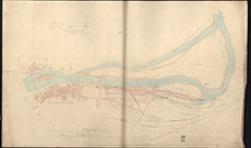 | ||
| Zoom Into Map: | Click on the map to view in greater detail. | |
| Name: | Stevenson, Robert, 1772-1850 ; Stevenson, Alan, 1807-1865 | |
| Description: | North Berwick. North Berwick & Elie Ferry | |
| Year: | 1845 | |
| Place: | North Berwick | |
| County: | East Lothian | |
| Subject: | Reference Material | |
| Inventory: | Series of 3 prints | |
| Colour: | Colour | |
| Media: | Printed | |
| Object: | Flat | |
| Physical: | Paper | |
| Size: | 390 mm x 690 mm | |
| Shelfmark: | MS.5857, 33 | |
| Show location on map ? | ||
| Name: | Stevenson, Robert, 1772-1850 ; Stevenson, Alan, 1807-1865 | |
| Description: | North Berwick. North Berwick & Elie Ferry | |
| Year: | 1845 | |
| Place: | North Berwick | |
| County: | East Lothian | |
| Subject: | Reference Material | |
| Inventory: | Series of 3 prints | |
| Colour: | B&W | |
| Media: | Ink | |
| Object: | Flat | |
| Physical: | Paper | |
| Size: | 500 mm x 680 mm | |
| Shelfmark: | MS.5857, 34 | |
| Show location on map ? | ||
| Name: | Stevenson, Robert, 1772-1850 ; Stevenson, Alan, 1807-1865 | |
| Description: | North Berwick. North Berwick & Elie Ferry | |
| Year: | 1845 | |
| Place: | North Berwick | |
| County: | East Lothian | |
| Subject: | Reference Material | |
| Inventory: | Series of 3 prints | |
| Colour: | B&W | |
| Media: | Ink | |
| Object: | Flat | |
| Physical: | Paper | |
| Size: | 500 mm x 680 mm | |
| Shelfmark: | MS.5857, 35 | |
| Show location on map ? | ||
| Name: | Stevenson, Robert, 1772-1850 | |
| Description: | Tay, River. Junction of Tay and Earn and effect of railway on Tay navigation | |
| Year: | 1845 | |
| County: | Perth | |
| Subject: | Railway | |
| Inventory: | 6 prints by Geo. Aikman | |
| Colour: | Colour | |
| Media: | None | |
| Object: | Flat | |
| Physical: | Card | |
| Size: | 615 x 1240 mm | |
| Shelfmark: | MS.5863, 48 | |
| Show location on map ? | ||
| Name: | Stevenson, Robert, 1772-1850 | |
| Description: | Tay, River. Junction of Tay and Earn and effect of railway on Tay navigation | |
| Year: | 1845 | |
| County: | Perth | |
| Subject: | Railway | |
| Inventory: | 6 prints by Geo. Aikman | |
| Colour: | Colour | |
| Media: | None | |
| Object: | Flat | |
| Physical: | Card | |
| Size: | 675 x 960 mm | |
| Shelfmark: | MS.5863, 49 | |
| Show location on map ? | ||
| Name: | Stevenson, Robert, 1772-1850 | |
| Description: | Tay, River. Junction of Tay and Earn and effect of railway on Tay navigation | |
| Year: | 1845 | |
| County: | Perth | |
| Subject: | Railway | |
| Inventory: | 6 prints by Geo. Aikman | |
| Colour: | Colour | |
| Media: | None | |
| Object: | Flat | |
| Physical: | Card | |
| Size: | 610 x 900 mm | |
| Shelfmark: | MS.5863, 50 | |
| Show location on map ? | ||
| Name: | Stevenson, Robert, 1772-1850 | |
| Description: | Tay, River. Junction of Tay and Earn and effect of railway on Tay navigation | |
| Year: | 1845 | |
| County: | Perth | |
| Subject: | Railway | |
| Inventory: | 6 prints by Geo. Aikman | |
| Colour: | Colour | |
| Media: | None | |
| Object: | Flat | |
| Physical: | Card | |
| Size: | 610 x 950 mm | |
| Shelfmark: | MS.5863, 51 | |
| Show location on map ? | ||
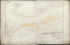 | ||
| Zoom Into Map: | Click on the map to view in greater detail. | |
| Name: | Stevenson, Robert, 1772-1850 | |
| Description: | Tay, River. Junction of Tay and Earn and effect of railway on Tay navigation | |
| Year: | 1845 | |
| County: | Perth | |
| Subject: | Railway | |
| Inventory: | 6 prints by Geo. Aikman | |
| Colour: | Colour | |
| Media: | None | |
| Object: | Flat | |
| Physical: | Card | |
| Size: | 610 x 960 mm | |
| Shelfmark: | MS.5863, 52 | |
| Show location on map ? | ||
| Name: | Stevenson, Robert, 1772-1850 | |
| Description: | Tay, River. Junction of Tay and Earn and effect of railway on Tay navigation | |
| Year: | 1845 | |
| County: | Perth | |
| Subject: | Railway | |
| Inventory: | 6 prints by Geo. Aikman | |
| Colour: | Colour | |
| Media: | None | |
| Object: | Flat | |
| Physical: | Card | |
| Size: | 770 x 1120 mm | |
| Shelfmark: | MS.5863, 53 | |
| Show location on map ? | ||
| Name: | Stevenson, Robert, 1772-1850 ; Stevenson, Thomas, 1818-1887 | |
| Description: | Scrabster. Plan and sections of low water pier | |
| Year: | 1846 & 1848 | |
| Place: | Scrabster | |
| County: | Caithness | |
| Subject: | Harbour | |
| Inventory: | Series of 5 drawings. 1846- Robert Stevenson ; 1848 - Thomas Stevenson | |
| Colour: | Colour | |
| Media: | None | |
| Object: | Flat | |
| Physical: | Oil cloth | |
| Size: | 300 x 325 mm | |
| Shelfmark: | MS.5862, 60 | |
| Show location on map ? | ||
 | ||
| Zoom Into Map: | Click on the map to view in greater detail. | |
| Name: | Stevenson, Robert, 1772-1850 ; Stevenson, Thomas, 1818-1887 | |
| Description: | Scrabster. Plan and sections of low water pier | |
| Year: | 1846 & 1848 | |
| Place: | Scrabster | |
| County: | Caithness | |
| Subject: | Harbour | |
| Inventory: | Series of 5 drawings. 1846- Robert Stevenson ; 1848 - Thomas Stevenson | |
| Colour: | Colour | |
| Media: | Linen/Cloth | |
| Object: | Flat | |
| Physical: | Transparent paper | |
| Size: | 300 x 450 mm | |
| Shelfmark: | MS.5862, 61 | |
| Show location on map ? | ||
| Name: | Stevenson, Robert, 1772-1850 ; Stevenson, Thomas, 1818-1887 | |
| Description: | Scrabster. Plan and sections of low water pier | |
| Year: | 1846 & 1848 | |
| Place: | Scrabster | |
| County: | Caithness | |
| Subject: | Harbour | |
| Inventory: | Series of 5 drawings. 1846- Robert Stevenson ; 1848 - Thomas Stevenson | |
| Colour: | B&W | |
| Media: | None | |
| Object: | Flat | |
| Physical: | Card | |
| Size: | 520 x 740 mm | |
| Shelfmark: | MS.5862, 62 | |
| Show location on map ? | ||
| Name: | Stevenson, Robert, 1772-1850 ; Stevenson, Thomas, 1818-1887 | |
| Description: | Scrabster. Plan and sections of low water pier | |
| Year: | 1846 & 1848 | |
| Place: | Scrabster | |
| County: | Caithness | |
| Subject: | Harbour | |
| Inventory: | Series of 5 drawings. 1846- Robert Stevenson ; 1848 - Thomas Stevenson | |
| Colour: | Colour | |
| Media: | Linen/Cloth | |
| Object: | Flat | |
| Physical: | Transparent paper | |
| Size: | 685 x 990 mm | |
| Shelfmark: | MS.5862, 63 | |
| Show location on map ? | ||
| Name: | Stevenson, Robert, 1772-1850 ; Stevenson, Thomas, 1818-1887 | |
| Description: | Scrabster. Plan and sections of low water pier | |
| Year: | 1846 & 1848 | |
| Place: | Scrabster | |
| County: | Caithness | |
| Subject: | Harbour | |
| Inventory: | Series of 5 drawings. 1846- Robert Stevenson ; 1848 - Thomas Stevenson | |
| Colour: | Colour | |
| Media: | None | |
| Object: | Flat | |
| Physical: | Card | |
| Size: | 630 x 950 mm | |
| Shelfmark: | MS.5862, 64 | |
| Show location on map ? | ||
| Name: | Stevenson, Robert, 1772-1850 ; Stevenson, Alan, 1807-1865 | |
| Description: | Perth. Harbour and proposed railways | |
| Year: | 1846 | |
| Place: | Perth | |
| County: | Perth | |
| Subject: | Harbour | |
| Inventory: | Series of six prints | |
| Colour: | Colour | |
| Media: | Hand coloured; Ink | |
| Object: | Flat | |
| Physical: | Paper | |
| Size: | 580 mm x 700 mm | |
| Shelfmark: | MS.5859, 30 | |
| Show location on map ? | ||
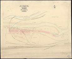 | ||
| Zoom Into Map: | Click on the map to view in greater detail. | |
| Name: | Stevenson, Robert, 1772-1850 ; Stevenson, Alan, 1807-1865 | |
| Description: | Perth. Harbour and proposed railways | |
| Year: | 1846 | |
| Place: | Perth | |
| County: | Perth | |
| Subject: | Harbour | |
| Inventory: | Series of six prints | |
| Colour: | Colour | |
| Media: | Hand coloured; Printed | |
| Object: | Flat | |
| Physical: | Paper | |
| Size: | 540 mm x 720 mm | |
| Shelfmark: | MS.5859, 31 | |
| Show location on map ? | ||
| Name: | Stevenson, Robert, 1772-1850 ; Stevenson, Alan, 1807-1865 | |
| Description: | Perth. Harbour and proposed railways | |
| Year: | 1846 | |
| Place: | Perth | |
| County: | Perth | |
| Subject: | Harbour | |
| Inventory: | Series of six prints | |
| Colour: | Colour | |
| Media: | Hand coloured; Printed | |
| Object: | Flat | |
| Physical: | Paper | |
| Size: | 500 mm x 720 mm | |
| Shelfmark: | MS.5859, 32 | |
| Show location on map ? | ||
| Name: | Stevenson, Robert, 1772-1850 ; Stevenson, Alan, 1807-1865 | |
| Description: | Perth. Harbour and proposed railways | |
| Year: | 1846 | |
| Place: | Perth | |
| County: | Perth | |
| Subject: | Harbour | |
| Inventory: | Series of six prints | |
| Colour: | Colour | |
| Media: | Hand coloured; Printed | |
| Object: | Flat | |
| Physical: | Paper | |
| Size: | 550 mm x 720 mm | |
| Shelfmark: | MS.5859, 33 | |
| Show location on map ? | ||
| Name: | Stevenson, Robert, 1772-1850 ; Stevenson, Alan, 1807-1865 | |
| Description: | Perth. Harbour and proposed railways | |
| Year: | 1846 | |
| Place: | Perth | |
| County: | Perth | |
| Subject: | Harbour | |
| Inventory: | Series of six prints | |
| Colour: | Colour | |
| Media: | Hand coloured; Printed | |
| Object: | Flat | |
| Physical: | Paper | |
| Size: | 540 mm x 720 mm | |
| Shelfmark: | MS.5859, 34 | |
| Show location on map ? | ||
| Name: | Stevenson, Robert, 1772-1850 ; Stevenson, Alan, 1807-1865 | |
| Description: | Perth. Harbour and proposed railways | |
| Year: | 1846 | |
| Place: | Perth | |
| County: | Perth | |
| Subject: | Harbour | |
| Inventory: | Series of six prints | |
| Colour: | Colour | |
| Media: | Hand coloured; Printed | |
| Object: | Flat | |
| Physical: | Paper | |
| Size: | 540 mm x 720 mm | |
| Shelfmark: | MS.5859, 35 | |
| Show location on map ? | ||
| Name: | Stevenson, Robert, 1772-1850 | |
| Description: | Glasgow. Outline of Hutcheson Bridge showing effect on foundations by deepending bed of river | |
| Year: | 1846 | |
| Place: | Glasgow | |
| County: | Lanark | |
| Subject: | Bridge | |
| Inventory: | Tracings. 2 copies | |
| Colour: | Colour | |
| Media: | Hand coloured; Ink | |
| Object: | Folded | |
| Physical: | Photographic process | |
| Size: | 705 mm x 1010 mm | |
| Shelfmark: | MS.5851, 54 | |
| Show location on map ? | ||
| Name: | Stevenson, Robert, 1772-1850 | |
| Description: | Glasgow. Outline of Hutcheson Bridge showing effect on foundations by deepending bed of river | |
| Year: | 1846 | |
| Place: | Glasgow | |
| County: | Lanark | |
| Subject: | Bridge | |
| Inventory: | Tracings. 2 copies | |
| Colour: | Colour | |
| Media: | Hand coloured; Ink | |
| Object: | Folded | |
| Physical: | Paper | |
| Size: | 710 mm x 565 mm | |
| Shelfmark: | MS.5851, 55 | |
| Show location on map ? | ||
| Name: | Stevenson, Robert, 1772-1850 | |
| Description: | Edinburgh: Leith. Survey of part of river and harbour | |
| Year: | 1882-3 | |
| Place: | Leith | |
| County: | Edinburgh | |
| Subject: | Harbour | |
| Inventory: | Drawing | |
| Colour: | Colour | |
| Media: | Hand coloured; Ink | |
| Object: | Folded | |
| Physical: | Paper | |
| Size: | 800 mm x 1625 mm | |
| Shelfmark: | MS.5848, 67 | |
| Show location on map ? | ||
| Name: | Stevenson, Robert, 1772-1850 | |
| Description: | Aberdeen. Harbour and Basin | |
| Year: | 1919 | |
| Place: | Aberdeen | |
| County: | Aberdeen | |
| Subject: | Harbour | |
| Inventory: | Drawing | |
| Colour: | Colour | |
| Media: | Graphite; Hand coloured; Ink | |
| Object: | Folded | |
| Physical: | Paper | |
| Size: | 570 mm x 1370 mm | |
| Shelfmark: | MS.5844, 11 | |
| Show location on map ? | ||