Maps of the World
| Field | Content |
|---|---|
| Name: | Higden, Ranulf, ca. 1280 – 1364 |
| Title: | [Map of the World] |
| Imprint: | 15th century |
| Pagination: | 1 map: col., 22 x 30 cm |
| Shelfmark: | Adv.MS.33.4.12 |
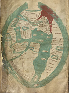
| Notes: | This map of the World is taken from the work of the Benedictine monk, Ranulph Higden, and it is the earliest manuscript map held by the National Library of Scotland. Higden spent 60 years of his life at St Werburgh’s Abbey in Chester, and he is chiefly remembered today as the author of the Polychronicon, a seven-volume history of the world. Versions of the Polychronicon written after 1340 often include a mappa mundi (Latin, meaning 'map of the world') to help readers locate some of the main places described in the text. Orientated with east to the top, the three continents of the known world 一 Europe to the lower left, Asia to the top, and Africa to the right 一 are surrounded by a green band of ocean, with the Red Sea and Persian Gulf coloured in red. By this time on mappae mundi, the iconic, circular T-O map form showing the world as a perfect sphere, had morphed into an ovoid shape to take account of more recent discoveries. The map names over 100 places, some clearly recognisable, such as Babylon, the Euphrates river, Jerusalem, Sinai, Arabia and Syria to the upper centre. The names of 'Scocia' and 'Anglia' (for 'Scotland' and 'England', shown on the same island), can just be read, squeezed onto the lower-left hand edge. View the complete manuscript copy of Ranulph Higden's Polychronicon in which this map can be found, on the Library's Early Manuscripts website. |
| Zoom Into Map: | Click on the map to view in greater detail. |