Town Plans / Views, 1580s-1940s
| Field | Content |
|---|---|
| Name: | W.M |
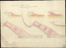
| Title: | Buckie - Harbour; proposed method of protecting south end of West Pier |
| Imprint: | 1856 |
| Pagination: | 1 map : col.; 510 x 700 mm. |
| Shelfmark: | MS.5845, No.73 |
| Zoom Into Map: | Click on the map to view in greater detail. |
| Notes: | This map is from our Stevenson civil engineering plans collection. |