Roy Military Survey of Scotland, 1747-1755
Scope of the Survey and Field survey methods
The Roy Military Survey was significantly limited by the availability of men, equipment and time, especially when compared with the Ordnance Survey a century later. The Board of Ordnance were rarely able to properly finance their work in Scotland, and Colonel David Watson paid for much of the execution of the Survey.

© National Library of Wales
In 1748, there were only four engineers available for work in Scotland, all of whom were involved in road construction. Although at this time the King approved an increase in engineers, and some practitioner engineers were appointed, only Lieutenant Hugh Debbeig was named as working on the Survey, and some of these additional engineers were in fact draughtsmen.
The original intention had been only to survey the Highlands, but when it was largely complete by 1752, the Survey was extended to southern Scotland, south of the Forth-Clyde rivers. The reasons were administrative, rather than military. The outbreak of war in 1755 curtailed operations as Watson and other engineers were ordered elsewhere. Nevertheless, this was the first time the whole of the Scottish mainland - the islands were excluded - had been mapped at once to the same specification, and it had taken just eight years.
Field survey methods

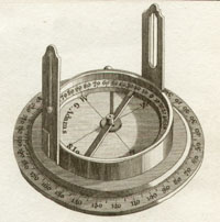
The Roy Military Survey was not based on triangulation, but on a set of measured traverses along important features using circumferentors (or surveying compasses for measuring angles) and chains for measuring distances. Some of these traverses can be seen as straight lines between observations points. Each surveying party consisted of an engineer with an NCO and six soldiers: one carried the circumferentor, two measured with the chain; two for the fore and back stations, and one acted as batman.
The circumferentors were fairly simple, of seven inches in diameter and with common sights without telescopes, while the chains for measuring distance were 45-50 feet long. Only selected landscape features, such as roads, rivers and lochs, were instrumentally surveyed this way. The remaining landscape features - towns and settlements, enclosures and woodland, as well as relief - were sketched in by eye or copied from existing maps.
The composite map
Considerable adjustment was required to bring the separate traverses together, following mutual discussion among separate surveying parties. Following active surveying in the summer months, the surveyors returned in the autumn and winter to the Board of Ordnance drawing office in Edinburgh, where the composite map known as the 'original protraction' was prepared. Notably, the map was never graduated for latitude nor longitude, nor presented with a standard scale, and its orientation was always towards magnetic north, the declination at this date taken to be 19 degrees west.
View the Roy map:
- Map with gazetteers
- Full screen map - Highlands or Lowlands
Further Information
- Introduction
- Background to the Survey and William Roy
- Scope of the Survey and Field survey methods
- Cartographic style and content
- Map originals, images and bibliography
- Roy Gazetteer
