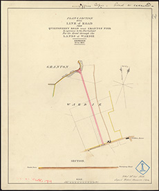
Town Plans / Views, 1580s-1940s
| Field | Content |
|---|---|
| Name: | Stevenson, Robert, 1772-1850 |
| Title: | Granton - Plan of road from Granton Pier to Leith and Queensferry Road |
| Imprint: | 1835 |
| Pagination: | 1 map : col.; 375 x 313 mm. |
| Shelfmark: | MS.5848, No.50 |
| Zoom Into Map: | Click on the map to view in greater detail. |
| Notes: | This map is from our Stevenson civil engineering plans collection. |