Town Plans / Views, 1580s-1940s
| Field | Content |
|---|---|
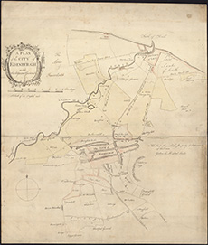
| Name: | Cooper, Richard, c. 1705-1764 |
| Title: | A plan of the city of Edinburgh with the adjacent grounds / [engraved by Richard Cooper] |
| Imprint: | [Edinburgh, 1759] |
| Pagination: | 1 map ; 453 x 388 mm |
| Shelfmark: | Signet.s.080 |
| Zoom Into Map: | Click on the map to view in greater detail. |
| Notes: | We are very grateful to the WS Society for their permission to display this map online. View Signet Library collection maps of Scotland held at NLS. |