Estate Maps, 1750s-1900s

| Name: | Gordon, David, 1820-1893 |
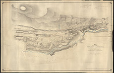
| Title: | Plan of the Lands of Boblainy and Femenig 1858. and the Arable Lands of Clunevackie and Inshtaing together with Part of the Glen of Boblainy Plantation 1865. |
| Imprint: | 1865 |
| Pagination: | 1 manuscript map: col.; 97 x 150 cm. |
| Shelfmark: | Lovat131 |
| Notes: | Map used in disposition 1859. Handwritten top right: Beauly 26th March 1859, etc (details of the signatories to the agreement) Scale 1:2376. (30 chains = 10" ). Courtesy of Lovat Highland Estates and the North of Scotland Archaeological Society. View Lovat Highland Estates mapping |
| Zoom Into Map: | Click on the map to view in greater detail. |