Estate Maps, 1750s-1900s

| Name: | Gordon, David, 1820-1893 |
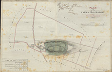
| Title: | Plan of the Farm of Balcraggan with Proposed Additions, 1867. |
| Imprint: | 1867 |
| Pagination: | 1 manuscript map: col.; 44 x 68 cm. |
| Shelfmark: | Lovat098 |
| Notes: | Map used in an 1868 disposition. Handwritten on top right, with details of the agreement Scale 1:2376. (15 chains = 5" ). Courtesy of Lovat Highland Estates and the North of Scotland Archaeological Society. View Lovat Highland Estates mapping |
| Zoom Into Map: | Click on the map to view in greater detail. |