Estate Maps, 1750s-1900s

| Name: | Lane, John |
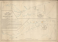
| Title: | Plans of the Estuaries and Friths of the Rivers or Waters of the Ness, Beauly and Tay from the Admiralty Charts of the Coasts. |
| Imprint: | 1830, 1845 |
| Pagination: | 1 map: col.; 47 x 66 cm. |
| Shelfmark: | Lovat085 |
| Notes: | A map produced by John Lane, Lithographer, Holbourn and Westmnister, showing the "Friths" (sic) of the Moray and Beauly Firths 1845 and the Firth of Tay 1830 Scale 1:73820. (7 miles = 6" ). Courtesy of Lovat Highland Estates and the North of Scotland Archaeological Society. View Lovat Highland Estates mapping |
| Zoom Into Map: | Click on the map to view in greater detail. |