Maps of Scotland
| Field | Content |
|---|---|
| Name: | Richardson, Ralph (1845-1933) John Bartholomew & Co. Ltd. |
| Title: | Earthquake Map of Scotland |
| Imprint: | Edinburgh: Edinburgh Geological Society, 1892 |
| Pagination: | 1 map: col., 33 x 23 cm |
| Shelfmark: | Y.214 |
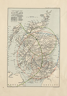
| Notes: | This is Scotland’s first earthquake map, showing the main areas affected by each of the six largest earthquakes that had occurred in the last century. As its author, Ralph Richardson, makes clear ‘Scotland has by no means an immunity from earthquakes. On the contrary…several earthquakes of considerable energy and affecting a wide area have periodically occurred.’ In an age before any comprehensive seismological recording, Richardson’s data was effectively compiled from written accounts in journals, along with various environmental details to identify patterns and causes - these included recent pressure and temperature changes, phase of the moon, time of day, and season in the year. The Richter scale was developed from the 1930s, and so descriptions of intensity were therefore more evocative - in Relugas (1816), the “seismic sound resembled a great many pieces of heavy artillery driven furiously over a vaulted pavement”. The map shows how geography would play a key role in understanding earthquakes; although Comrie on the Highland Boundary Fault (with its dashed line in red) was recognised as being the possible epicentre of the earthquakes of 1801 and 1839, Inverness, Edinburgh and Phladda were considered the likely epicentres of the other earthquakes, but all with quite different geographic extents.
Ralph Richardson (1845-1933) worked as a lawyer in Edinburgh, but he was also a keen amateur geologist, co-founding the Edinburgh Geological Society in 1882, and serving as its first Vice-President. He was also very closely involved in RSGS, being present at the public meeting in October 1884 which launched the Society, and serving as its Honorary Secretary (1884-1923). He published widely on diverse subjects including banking and art, as well as on meteorology and geology, including the books The County of Edinburgh or Midlothian: Its Geology, Agriculture and Geology (1878) and The Influence of the Natural Features and Geology of Scotland on the Scottish People (1908). This map was published in the Transactions of the Edinburgh Geological Society, vol. 6 (1892), to accompany Ralph Richardson's paper 'On the more notable Scottish Earthquakes which have occurred during the present century'. |
| Zoom Into Map: | Click on the map to view in greater detail. |