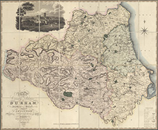
County maps, 1580s-1950s
| Field | Content |
|---|---|
| Name: | Greenwood, C. (Christopher), 1786-1855 |
| Title: | Map of the county palatine of Durham from actual survey made in the years 1818 & 1819 |
| Imprint: | London : Greenwood, Pringle & Co., 1820 |
| Pagination: | 1 map ; 1008 x 1226 mm. |
| Shelfmark: | EME.b.5.15 |
| Notes: | Scale: 1 inch to a mile. View georeferenced map. |
| Zoom Into Map: | Click on the map to view in greater detail. |