Ordnance Survey Characteristic Sheets

decorative graphic illustrating this particular set of maps

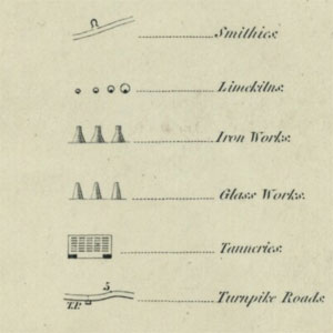
The Ordnance Survey Characteristics Sheet collection (held at Map.X3.234) is a set of 40 items, dating between ca. 1840-1930, containing specimens of type, symbols and characteristics for various Ordnance Survey map series. Characteristics sheets or legends are crucial for interpreting the symbols and features used on early Ordnance Survey maps. However, Ordnance Survey did not regularly publish this information in a standard form for many map series in the 19th century, so this collection has a particular value and some items may be unique.

Further information about this collection.

We are very grateful to the Aurelius Trust for funding the conservation and digitisation of this collection.

The set below is ordered roughly by scale, with a set of "miscellaneous" items at the end which cover various scales:

Large-scale Town Plans

View sheets:
FolioTitleDate of publication
27Ordnance Surveys. Character of Writing to be used on the 5-Feet and 1/500 Plans

25 Inch to the mile

View sheets:
FolioTitleDate of publication
36Conventional Signs and Writing Used on the 1/2500 Plans of the Ordnance Survey. Plate I.ca. 1923

Six-Inch to the Mile

View sheets:
FolioTitleDate of publication
1Ordnance Survey of Ireland. Characteristic Sheet for maps on a scale of Six Inches to a Mile
2Ordnance Survey Characteristic Sheet for the Engraved Six Inch Maps of Great Britain1897
3Ordnance Survey Characteristic Sheet for the Engraved Six Inch Maps of Great Britain1897
4Examples for the Characters of the Writing on the Engraved Six Inch Ordnance Maps of Great Britain1897
5Examples for the Characters of the Writing to the Ordnance Map of Great Britain on a Scale of 6 Inches to a Mile1847
6Examples for the Characters of the Writing on the Engraved Six Inch Ordnance Maps of Great Britain1897
7Scale of Shade for Hills on the Six Inch Map of the Ordnance Survey
8Untitled [Ordnance Survey Characteristic Sheet for the Engraved Six Inch Maps of Great Britain?]
9Untitled [Ordnance Survey Characteristic Sheet for the Engraved Six Inch Maps of Great Britain?]
37Conventional Signs and Writing Used on the Six Inch Maps of the Ordnance Survey. Plate IV.ca. 1923

One-Inch to the Mile

View sheets:
FolioTitleDate of publication
10Examples for the Size and Characters of the Names in the Ordnance Map.
11Characteristic Sheet for the One Inch Engraving of Scotland and Ireland
12Characteristic Sheet for the One Inch Map of England & Wales
13Ordnance Survey Characteristic Sheet for the Revised One-Inch Map of Great Britain.1897
14Ordnance Survey Characteristic Sheet for the Revised One-Inch Map of Great Britain.1897
15Ordnance Survey Characteristic Sheet for the Revised One-Inch Map of Great Britain and Ireland1898
16Ordnance Survey Conventional Signs and Writing for the Revised One-Inch Map of Great Britain. (Popular Edition)1924
Ordnance Survey Conventional Signs and Writing for the Revised One-Inch map of Great Britain (5th edition).1932
Ordnance Survey Conventional Signs and Writing for the Revised One-Inch map of Great Britain (5th edition).1933

Half-Inch to the Mile

View sheets:
FolioTitleDate of publication
20Ordnance Survey Conventional Signs and Writing for the Revised 1/2 Inch Map of Great Britain1923

Quarter-Inch to the Mile

View sheets:
FolioTitleDate of publication
17Ordnance Survey Characteristic Sheet for the Revised Four-Mile Map of Great Britain.1900
18Ordnance Survey Characteristic Sheet for the Revised Four-Mile Map of Great Britain and Ireland.1900
19Conventional Signs and Writing for the New Series 1/4 Inch Map of Great Britain

Ten-Mile to the Inch

View sheets:
FolioTitleDate of publication
21Ordnance Survey Characteristic Sheet for the Revised Ten-Mile Map of Great Britain.1900
22Ordnance Survey Characteristic Sheet for the Revised Ten-Mile Map of Great Britain.1900

Symbols, specimen alphabets, conventional signs at different scales

View sheets:
FolioTitleDate of publication
23Examples of the Characters of Writing and the Characteristics of the Photozincographed Maps of the Ordnance Survey with instructions as to their use.1897
24Symbols to be used on Plans of the Ordnance Survey1883
25Parish Indexes. Specimen to guide draftsmen in preparing 6 Inch Plans for reduction to 1 Inch scale.
26rA Specimen of the Print Hands, for the Instruction of the Cadets, in the Corps of Royal Military Surveyors and Draftsmen, Engraved by desire of Lieutenant General Mann, Inspector General of Fortifications.
26vTable Showing different kinds of Type with their ordinary names as used on the Ordnance Survey1885
28Specimen Alphabets
29Specimen Sheet of Type used in the Production of Ordnance Survey Plans
30Specimen Sheet of Type used in the Production of Ordnance Survey Plans
31Specimen of Stamps Used For the Revision Survey1923
32Untitled [Contours Specimen Sheet?]
33Ordnance Survey of Great Britain. These sketches show the method adopted for indicating public boundaries on Ordnance Survey Maps… All these cases numbered hereon are specially referred to in the 1914 Edition of "Notes on Boundaries."
34Specimen of the Stamps Used for Plans on the 1/500 1/2500 and 6 Inch Scales1886
35Specimen Sheet of Type used in the Production of Ordnance Survey Plans.
Character of Writing for Ordnance Survey Plans (PDF)1881
Character of Writing used on Ordnance Survey Plans (OS 404) (PDF)1914
Notes on Archaeology for Guidance in the Field (PDF)1921