Military Maps of Scotland (18th century)
Your search returned 3 records.
Ordered chronologically (undated items first).
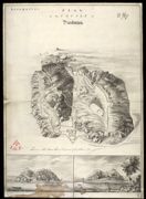
| Title: | Plan of the Castle of Dunbarton. | |
| Name: | [Sandby, Paul (Draughtsman)] | |
| Shelfmark: | MS.1649 Z.03/57 | |

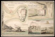
| Title: | Plan of Castle Tyrim in Muydart; Plan of Castle Duirt in the Island of Mull 1748 [copy] | |
| Name: | Watson, David (Engineer) Sandby, Paul (Draughtsman) | |
| Survey: | 1748 | |
| Shelfmark: | MS.1648 Z.03/28d | |
| Title: | Plan of Castle Tyrim in Muydart; Plan of Castle Duirt in the Island of Mull 1748 | |
| Name: | Watson, David (Engineer) Sandby, Paul (Draughtsman) | |
| Survey: | 1748 | |
| Shelfmark: | MS.1648 Z.03/28e | |