Military Maps of Scotland (18th century)
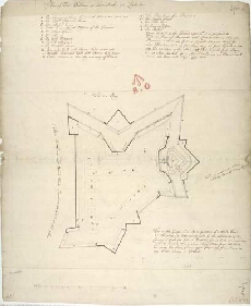
| Title: | Plan of Fort William at Inverlochie in Lochaber |
| Name: | [Dury, Theodore (Engineer)] |
| Description: | 1 manuscript map ; 545 x 675 mm. |
| Original Survey: | [ca.1710] |
| Date on Map: | [ca.1710] |
| Placename: | Fort William |
| Parish: | Kilmallie |
| County: | Inverness-shire |
| Shelfmark: | MS.1646 Z.02/24b |
| Zoom Into Map: | Click on the map to view in greater detail. |
All images © Crown Copyright and © National Library of Scotland