Military Maps of Scotland (18th century)
| Field | Content |
|---|---|
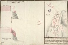
| Title: | A Plan of Sterling Castle, as here Color'd in Red lines, and the Black is a Design for better Fortifying the Entrance of the same; A profile of Elphinstons Tower and French Spur at Sterling Castle [1708] [copy] |
| Name: | Dury, Theodore (Engineer) Edwards, Talbot (Engineer) |
| Description: | 1 manuscript map ; 394 x 611 mm., on sheet, 435 x 644 mm. |
| Original Survey: | [1708?] |
| Date on Map: | 1708 |
| Placename: | Stirling |
| Parish: | Stirling |
| County: | Stirlingshire |
| Shelfmark: | MS.1646 Z.02/23c |
| Zoom Into Map: | Click on the map to view in greater detail. |
All images © Crown Copyright and © National Library of Scotland