Military Maps of Scotland (18th century)
| Field | Content |
|---|---|
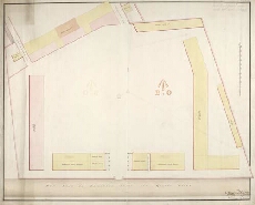
| Title: | [Leith Battery; Plan of] New Ground with stables, additional storehouses, guard house, new barracks and gun shed |
| Name: | Evatt, Henry (Engineer) |
| Description: | 1 manuscript map ; 477 x 593 mm., on sheet, 504 x 624 mm. |
| Original Survey: | [pre-1804] |
| Date on Map: | [pre-1804] |
| Placename: | Leith |
| Parish: | Leith |
| County: | Edinburghshire/Midlothian |
| Shelfmark: | MS.1650 Z.46/17d |
| Zoom Into Map: | Click on the map to view in greater detail. |
All images © Crown Copyright and © National Library of Scotland