Military Maps of Scotland (18th century)
| Field | Content |
|---|---|
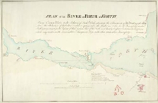
| Title: | Plan of the River or Firth of Forth [1782] [copy] |
| Name: | Colebrooke, Pawlett William (Engineer) |
| Description: | 1 manuscript map ; 388 x 602 mm., on sheet, 443 x 655 mm. |
| Original Survey: | 1782 |
| Date on Map: | 1782 |
| Placename: | Leith |
| Parish: | Leith |
| County: | Edinburghshire, Midlothian |
| Shelfmark: | MS.1649 Z.03/47b |
| Zoom Into Map: | Click on the map to view in greater detail. |
All images © Crown Copyright and © National Library of Scotland