Military Maps of Scotland (18th century)
| Field | Content |
|---|---|
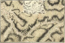
| Title: | A Survey of the Road made by the Detatchments Colln. Rich's & Genl. Guise's Regts. between Fort William & the head of King-loch Leven 1750 |
| Name: | Archer, John (Engineer) |
| Description: | 1 manuscript map ; 395 x 316 mm. |
| Original Survey: | 1750 |
| Date on Map: | 1750 |
| County: | Inverness-shire |
| Shelfmark: | MS.1649 Z.03/40a |
| Zoom Into Map: | Click on the map to view in greater detail. |
All images © Crown Copyright and © National Library of Scotland