Military Maps of Scotland (18th century)
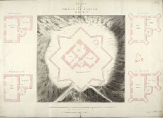
| Title: | Plans of Brae-Marr Castle in the Year 1750 [copy] |
| Name: | Skinner, William (Engineer) Tarrant, Charles (Draughtsman) Burr, G.D. (Copyist) |
| Description: | 1 manuscript map ; 519 x 725 mm., on sheet, 527 x 730 mm. |
| Original Survey: | 1750 |
| Date on Map: | 1750 |
| Placename: | Braemar Castle |
| Parish: | Crathie and Braemar |
| County: | Aberdeenshire |
| Shelfmark: | MS.1649 Z.03/31c |
| Zoom Into Map: | Click on the map to view in greater detail. |
All images © Crown Copyright and © National Library of Scotland