Military Maps of Scotland (18th century)
| Field | Content |
|---|---|
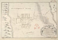
| Title: | A Plan of ye Battle of Colloden between his Majs. Forces Under the Command of his Royall Highness the Duke of Cumberland and the Sctt. Rebels April ye 16 1746 |
| Name: | Jones, Jasper Leigh (Draughtsman) |
| Description: | 1 manuscript map ; 237 x 366 mm., on sheet, 297 x 431 mm. |
| Original Survey: | 1746 |
| Date on Map: | 1746 |
| Placename: | Culloden |
| Parish: | Inverness, Croy, Daviot and Dunlichity |
| County: | Inverness-shire |
| Shelfmark: | MS.1648 Z.03/30b |
| Zoom Into Map: | Click on the map to view in greater detail. |
All images © Crown Copyright and © National Library of Scotland