Military Maps of Scotland (18th century)
| Field | Content |
|---|---|
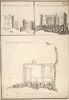
| Title: | Plan of Castle Douart in the Isle of Mull [copied between 1755 and 1759]; Prospect of the Front of Castle Douart; Prospect of Castle Douart from the Sea |
| Name: | Petit, Lewis (Engineer) Mulcaster, Frederick (Engineer) |
| Description: | 1 manuscript map ; 500 x 355 mm., on sheet, 525 x 366 mm. |
| Original Survey: | [1714] |
| Date on Map: | [1714] |
| Placename: | Castle Duart |
| Parish: | Torosay |
| County: | Argyllshire |
| Shelfmark: | MS.1648 Z.03/28c |
| Zoom Into Map: | Click on the map to view in greater detail. |
All images © Crown Copyright and © National Library of Scotland