Military Maps of Scotland (18th century)
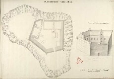
| Title: | Plan of Castle Tyrholme; View of Castle Tyrholme on the Sides C,A,B [copy] 1741 |
| Name: | Petit, Lewis (Engineer) |
| Description: | 1 manuscript map ; 503 x 736 mm., on sheet, 512 x 746 mm. |
| Original Survey: | 1741 |
| Date on Map: | 1741 |
| Placename: | Tioram |
| Parish: | Ardnamurchan |
| County: | Inverness-shire |
| Shelfmark: | MS.1648 Z.03/25b |
| Zoom Into Map: | Click on the map to view in greater detail. |
All images © Crown Copyright and © National Library of Scotland