Military Maps of Scotland (18th century)
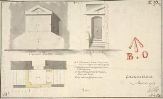
| Title: | Church Portch; No.I; Edinburgh Castle; April 25 1719 |
| Name: | Jelfe, Andrews (Architect) |
| Description: | 1 manuscript map ; 172 x 284 mm., on sheet, 180 x 293 mm. |
| Original Survey: | 1719 |
| Date on Map: | April 25, 1719 |
| Placename: | Edinburgh Castle |
| Parish: | Edinburgh |
| County: | Edinburghshire/Midlothian |
| Shelfmark: | MS.1645 Z.02/02a |
| Zoom Into Map: | Click on the map to view in greater detail. |
All images © Crown Copyright and © National Library of Scotland