Military Maps of Scotland (18th century)
| Field | Content |
|---|---|
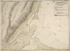
| Title: | A Plan of Fort William in the Shire of Inverness, with the District as is described by the Occult lines markt with yel=low & bounded by the River Navis. |
| Name: | [Wade, George (Engineer)] |
| Description: | 1 manuscript map : col. ; 304 x 417 mm. |
| Original Survey: | 1736 |
| Date on Map: | 1736 |
| Placename: | Fort William |
| Parish: | Kilmallie |
| County: | Inverness-shire |
| Shelfmark: | Acc.10497 Wade.58p |
| Zoom Into Map: | Click on the map to view in greater detail. |
All images © National Library of Scotland