Military Maps of Scotland (18th century)
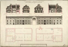
| Title: | Plan Elevation and Sections of the Store-House for Provisions, and Barrack-Masters Stores 1762 |
| Name: | Skinner, William (Engineer) |
| Description: | 1 manuscript map ; 506 x 732 mm., on sheet, 538 x 744 mm. |
| Original Survey: | 1762 |
| Date on Map: | 1762 |
| Placename: | Fort George (Ardersier) |
| Parish: | Ardersier |
| County: | Inverness-shire |
| Shelfmark: | MS.1647 Z.02/55a |
| Zoom Into Map: | Click on the map to view in greater detail. |
All images © Crown Copyright and © National Library of Scotland