Military Maps of Scotland (18th century)
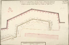
| Title: | Plan of the Foundations of Prince Henry Fredericks Bastion with the proposed Sheds for Carpenters, Smiths and Wheelwrights Shops with Room for Shott Pounds for Shott and Shells 1762 [copy] |
| Name: | Skinner, William (Engineer) |
| Description: | 1 manuscript map ; 340 x 511 mm., on sheet, 355 x 537 mm. |
| Original Survey: | 1762 |
| Date on Map: | 1762 |
| Placename: | Fort George (Ardersier) |
| Parish: | Ardersier |
| County: | Inverness-shire |
| Shelfmark: | MS.1647 Z.02/54b |
| Zoom Into Map: | Click on the map to view in greater detail. |
All images © Crown Copyright and © National Library of Scotland