Military Maps of Scotland (18th century)
| Field | Content |
|---|---|
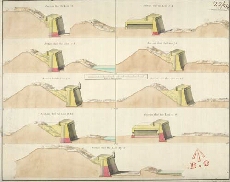
| Title: | [Plan of Fort George 1754] Section thro' the Line 1.2; Section thro' the Line 3.4; Section thro' the Line 5.6; Section thro' the Line 7.8; Section thro' the Line 9.10; Section thro' the Line 11.12; Section thro' the Line 13.14; Section thro' the Line 15.1 |
| Name: | Skinner, William (Engineer) Tarrant, Charles (Draughtsman) |
| Description: | 1 manuscript map ; 362 x 457 mm., on sheet, 376 x 472 mm. |
| Original Survey: | 1754 |
| Date on Map: | 1754 |
| Placename: | Fort George (Ardersier) |
| Parish: | Ardersier |
| County: | Inverness-shire |
| Shelfmark: | MS.1646 Z.02/49b |
| Zoom Into Map: | Click on the map to view in greater detail. |
All images © Crown Copyright and © National Library of Scotland