Military Maps of Scotland (18th century)
| Field | Content |
|---|---|
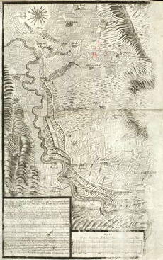
| Title: | [Plan of the Battle of Sheriffmuir, fought 13 November 1715] [copy] |
| Name: | [Lascelles, Thomas (Engineer)] |
| Description: | 1 map ; 528 x 370 mm., on sheet, 616 x 389 mm. |
| Original Survey: | [1719?] |
| Date on Map: | [1719?] |
| Placename: | Sheriffmuir |
| Parish: | Dublane |
| County: | Perthshire |
| Shelfmark: | MS.1649 Z.03/45c |
| Zoom Into Map: | Click on the map to view in greater detail. |
All images © Crown Copyright and © National Library of Scotland