Military Maps of Scotland (18th century)
| Field | Content |
|---|---|
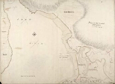
| Title: | Plan of the Fort Barrack Bernera in Glen Elg [1719] [copy] |
| Name: | Bastide, John Henri (Engineer) |
| Description: | 1 manuscript map ; 509 x 690 mm., on sheet, 525 x 731 mm. |
| Original Survey: | 1719 |
| Date on Map: | 1719 |
| Placename: | Glen Elg (Bernera) |
| Parish: | Glenelg |
| County: | Inverness-shire |
| Shelfmark: | MS.1647 Z.03/06d |
| Zoom Into Map: | Click on the map to view in greater detail. |
All images © Crown Copyright and © National Library of Scotland