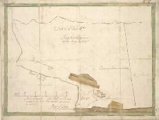
Military Maps of Scotland (18th century)
| Field | Content |
|---|---|
| Title: | [Plan of] District of Fort Wm. |
| Name: | [Wade, George (Engineer)] |
| Description: | 1 manuscript map : col. (green border) ; 258 x 351 mm., on sheet, 293 x 385 mm. |
| Original Survey: | 1728 |
| Date on Map: | 1728 |
| Placename: | Fort William |
| Parish: | Kilmallie |
| County: | Inverness-shire |
| Shelfmark: | Acc.10497 Wade.58i |
| Zoom Into Map: | Click on the map to view in greater detail. |
All images © National Library of Scotland