Military Maps of Scotland (18th century)
| Name: | Marcell, Lewis |
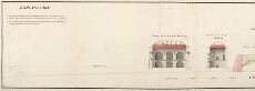
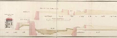
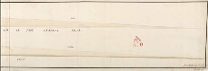
| Title: | [Profiles to accompany Z.2/83a - Plan of New Fort done on lines of Oliver's Fort] |
| Original Survey: | 1746 |
| Date on Map: | 1746 |
| Description: | 1 manuscript map ; 280 x 982 mm |
| Placename: | Fort George (Inverness) |
| Parish: | Inverness and Bona |
| County: | Inverness-shire |
| Shelfmark: | MS.1647 Z.02/83b |
| Zoom Into Map: | Click on the maps below to order image or view in greater detail. |
All images © Crown Copyright and © National Library of Scotland
Copyright Enquiries & Copies Help