Town Plans / Views, 1580s-1940s
| Name: | Church of Scotland. Presbytery of Edinburgh. |
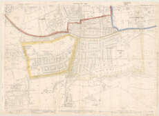
| Title: | [Hand drawn and coloured map showing boundary of Braid parish, Morningside, Edinburgh] |
| Pagination: | 1 map : colour ; 17 x 54 cm + 1 letter |
| Shelfmark: | Map.l.94.16 and Map.l.94.17 |
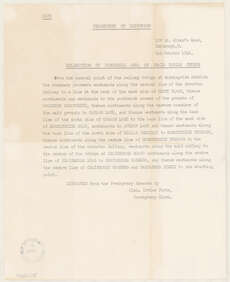
| Note: | Includes accompanying letter titled Delineation of parochial area of Braid parish church, dated 6th October 1948. Extracted from Presbytery records by Alex Irvine Pirie. |
| Zoom Into Map: | Click on the maps below to order image or view in greater detail. |
 |
 |