Estate Maps, 1750s-1900s

| Name: | Buchanan, George, 1790-1852 |
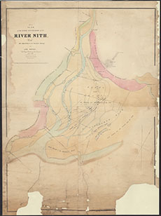
| Title: | No. 1 Plan of the Lower Boundaries of the River Nith, with the Channels and Banks thereof at Low Water |
| Imprint: | 1836 |
| Pagination: | 1 manuscript map: col.; 109 x 80 cm. |
| Shelfmark: | GGD749/5/6 |
| Notes: | Courtesy of the Ewart Library through the Dumfries Archival Mapping Project. |
| Zoom Into Map: | Click on the map to view in greater detail. |